Overview
Introduction: "Inside Our Earth" explains the internal structure of Earth and the dynamic processes that shape the surface. The chapter describes the layers of the Earth (crust, mantle and core), types of rocks and the rock cycle, and basic processes such as folding, faulting, volcanic activity and earthquakes. It introduces minerals and their uses and shows how internal Earth processes affect landforms and human life. Importance: Understanding the Earth's interior and the processes originating from within helps students explain mountain formation, the origin of rocks and minerals, the occurrence of earthquakes and volcanoes, and the distribution of natural resources. It builds scientific thinking and helps students appreciate the need for safe and sustainable use of Earth’s resources. Key themes: structure of the Earth (composition and properties of layers); types of rocks (igneous, sedimentary, metamorphic) and how they form; the rock cycle; geological processes (folding, faulting, volcanism) and their results (mountains, volcanoes, earthquakes); minerals and their economic uses; basic concepts of seismic activity and safety. What the student will learn: Students will be able…
Learning Objectives
- Define the internal structure of the Earth by naming and locating the crust, mantle, outer core and inner core.
- Describe the physical and chemical characteristics of each Earth layer (composition, temperature, and physical state).
- Explain how seismic waves (P‑waves and S‑waves) are used to infer the properties and boundaries of Earth's interior.
- Differentiate between continental and oceanic crust in terms of composition, thickness and age.
- Classify rocks into igneous, sedimentary and metamorphic groups and give one common example of each for examination answers.
- Explain the rock cycle and relate the processes (melting, cooling, erosion, compaction, metamorphism) to specific rock transformations.
- Identify the causes of earthquakes and define key terms: focus, epicentre, seismic waves, magnitude and intensity.
- Explain the causes, types (shield, composite, cinder cone) and typical features of volcanoes and volcanic eruptions.
Topics in this chapter
14 topics · tap a topic title to jump straight to it.
Introduction
What this topic is about
The Earth is not the same all the way through. From the outside to the centre it is made of different layers that differ in composition, state (solid or liquid), temperature and pressure. We cannot go deep inside the Earth, so scientists study the interior using indirect evidence such as seismic waves from earthquakes, rocks ejected by volcanoes, drilling, laboratory experiments and meteorites.
Main layers (chemical view)
- Crust: The thin outermost layer made mostly of silicate rocks. Thickness: about 5 km under oceans (oceanic crust) and up to 30–70 km under continents (continental crust).
- Mantle: Extends to about 2900 km depth. Made of denser silicate minerals (rich in magnesium and iron). It behaves solid but can flow very slowly over long times.
- Core: Iron–nickel rich. Outer core is liquid; inner core is solid. Core extends from ~2900 km to the centre (~6371 km).
Main layers (mechanical/rheological view)
- Lithosphere: Rigid outer shell made of crust and uppermost mantle. Broken into tectonic plates.
- Asthenosphere: Softer, partially plastic layer below the lithosphere on which plates move.
- Mesosphere (lower mantle): Stronger region of the mantle below the asthenosphere.
- Outer core: Liquid; its movement generates Earth’s magnetic field.
- Inner core: Solid due to immense pressure.
Important boundaries
- Moho (Mohorovičić discontinuity) — boundary between crust and mantle.
- Core–mantle boundary (Gutenberg discontinuity) at about 2900 km — marks the start of the liquid outer core.
How we know this
- Seismic waves: Earthquakes send P (primary) and S (secondary) waves through the Earth. P waves travel faster and through solids and liquids; S waves travel only through solids. The fact that S waves do not travel through the outer core and P waves are slowed/deflected tells us the outer core is liquid.
- Volcanoes and rocks: Mantle-derived rocks and volcanic materials give samples of deep-earth material.
- Meteorites: Some meteorites have compositions similar to Earth’s deep layers and help infer core composition.
Why it matters
Movement of the lithospheric plates (driven by mantle convection and the internal heat of Earth) causes earthquakes, volcanoes, mountain building and ocean formation. Understanding the Earth’s interior explains these surface processes and is essential for natural disaster awareness and resource studies.
Typical numbers (approximate)
- Earth radius: ~6371 km
- Crust thickness: 5–70 km
- Mantle thickness: ~2900 km
- Outer core: ~2270 km thick; inner core radius ~1220 km
- Temperature: increases with depth (geothermal gradient). Near surface ~15°C average; at core up to ~5000–6000°C (estimates).
Summary
The Introduction explains that Earth is layered, that each layer has characteristic material and physical properties, and that scientists use indirect evidence (especially seismic waves) to learn about the inaccessible interior. Plate motions driven by internal heat explain many geological phenomena we see at the surface.
- Himalaya formation: Collision of the Indian plate with the Eurasian plate (consequence of lithosphere movement) raised the Himalaya mountains.
- Barren Island volcano (Andaman Sea): A real Indian example of volcano formed by tectonic and mantle processes.
- 2001 Bhuj earthquake: A reminder that plate movements and stresses in the lithosphere produce earthquakes felt on the surface.
- Mid-Atlantic Ridge and sea-floor spreading: New oceanic crust is made as mantle material rises and solidifies along a divergent plate boundary.
- Seismic shadow zone: After a large earthquake, instruments on the opposite side of Earth often do not record S waves through the core, indicating the outer core is liquid.
- Density: density = mass / volume (ρ = m / V). Example: if a rock has mass 3000 kg and volume 1 m3, ρ = 3000 kg/m3.
- Hydrostatic (approximate) pressure with depth: P = ρ g h. Example: at 10 km depth in rock of average density 3000 kg/m3, P = 3000 × 9.8 × 10000 ≈ 2.94 × 10^8 Pa (≈ 294 MPa).
- Mass of a sphere (useful for whole-Earth estimates): M = ρ × (4/3) π R^3 if density ρ were uniform (Earth is not uniform, but formula gives order of magnitude).
- Simple wave-speed estimate (qualitative): v ≈ sqrt(E / ρ) where E is an elastic modulus and ρ is density. Faster waves imply stiffer materials; P and S wave speeds depend on elastic properties and density.
Layers of the Earth (General)
Overview
The Earth is made up of several concentric layers stacked like an onion. These layers differ in composition, state (solid or liquid), temperature, density and thickness. Scientists study seismic waves, meteorites and laboratory experiments to learn about these layers because we cannot directly access most of them.
Main layers (from outside to centre)
- Crust: The outermost, thin, rocky shell that we live on. There are two types: continental crust (thicker, ~30–70 km, less dense, mainly granite) and oceanic crust (thinner, ~5–10 km, denser, mainly basalt). Temperature ranges from near surface temperatures to a few hundred °C near the base. Density ≈ 2.7–3.0 g/cm³.
- Mantle: Extends from the base of the crust to about 2,900 km depth. It is made of silicate rocks rich in magnesium and iron. The uppermost mantle plus the crust make the rigid lithosphere (tectonic plates). Beneath is the partially molten, slowly flowing asthenosphere (helps plates move). Temperature in the mantle increases with depth (roughly 500–4,000 °C). Density increases with depth (≈ 3.3–5.7 g/cm³).
- Core: The central part of the Earth divided into the outer core (liquid) and inner core (solid). The outer core (about 2,200 km thick) is molten iron-nickel and convects to produce Earth’s magnetic field. The inner core (radius ≈ 1,220 km) is solid iron-nickel due to extremely high pressure despite very high temperature (est. 5,000–7,000 °C). Core densities ≈ 9.9–13 g/cm³.
How we know these layers exist
Seismic waves from earthquakes travel through Earth and change speed or disappear depending on the material they pass through. S-waves (shear waves) cannot pass through liquids, so their disappearance at certain depths shows a liquid outer core. Refraction and reflection of P-waves (compressional waves) give information about depths and densities. Laboratory studies of meteorites (which formed with Earth) and high-pressure experiments also inform composition estimates.
Why the layers matter
Layers explain phenomena such as earthquakes and volcanoes (movement of plates and mantle melts), mountain building (plate collision), the magnetic field (liquid outer core dynamo), distribution of minerals (located mostly in crust), and geothermal energy (heat from deep layers).
- Volcanoes: Magma originates from the mantle and rises through the crust during eruptions (e.g., Mount Vesuvius, Mount Fuji).
- Earthquakes: Stress release in the crust or upper mantle along faults causes seismic waves (e.g., Himalayan earthquakes from plate collision).
- Magnetic field: Movement of liquid iron in the outer core generates Earth’s magnetic field, which protects us from solar wind.
- Mineral extraction: Most ores (coal, metals, gemstones) are mined from the crust where they are concentrated.
- Geothermal springs and geysers: Heat from deep layers warms groundwater, producing hot springs (e.g., geothermal features in Iceland).
- Ocean trenches and mid-ocean ridges: Formed by subduction and seafloor spreading related to crust and upper mantle interactions.
- Density: ρ = mass / volume (ρ = m / V). Useful to compare how dense different layers are (units: kg/m³ or g/cm³).
- Pressure increase with depth (approximate for a fluid or layered medium): P = P0 + ρ g h, where P0 is surface pressure, ρ is density of overlying material, g is gravitational acceleration (~9.8 m/s² near surface), and h is depth.
- Newton’s gravitational acceleration (useful conceptually): g = G M / R², where G is gravitational constant, M is mass of Earth and R radius — shows why g changes little near surface but would vary inside a different body.
The Crust
What is the crust?
The crust is the Earth’s outermost solid layer. It is a thin, rocky shell that forms the land we live on and the floor of the oceans. The crust sits above the mantle and is separated from it by a boundary called the Mohorovičić discontinuity (Moho), which was discovered using seismic waves.
Types and thickness
- Continental crust: thick (about 30–70 km), made mainly of lighter, granitic rocks (lower density ~2700 kg/m³).
- Oceanic crust: thin (about 5–10 km), made mainly of denser basaltic rocks (density ~3000 kg/m³).
Composition
The crust is made of many minerals. The most abundant elements are oxygen and silicon (silicates). Other important elements are aluminium, iron, calcium, sodium, potassium and magnesium. Common rock types that make up the crust are igneous (granite, basalt), sedimentary (sandstone, limestone) and metamorphic (schist, gneiss).
Physical conditions
Temperature and pressure increase with depth in the crust. The rate at which temperature increases is called the geothermal gradient (about 20–30 °C per km near the surface, varying by location). Density differences explain why continental crust stands higher (forms continents) while oceanic crust forms basins.
Processes involving the crust
- Plate tectonics: the crust is broken into plates that move. New oceanic crust forms at mid-ocean ridges, and old oceanic crust is pushed down (subducted) at trenches.
- Earthquakes and volcanoes: most occur at plate boundaries in the crust or upper mantle.
- Isostasy: the crust 'floats' on the denser, more plastic mantle; thicker crust sits higher, explaining mountain roots.
- Rock cycle: rocks at the crust surface are weathered to form soils and sediments; buried rocks may melt or transform into other rock types.
Importance for humans
The crust provides soil for farming, and contains natural resources such as coal, petroleum (in sedimentary basins), metallic ores (iron, copper, bauxite), building stones and groundwater. Understanding the crust helps predict earthquakes, find minerals, and manage land.
How we study the crust
Geologists use seismic waves, rock samples from drilling, field mapping, and geophysical surveys (gravity, magnetic) to learn about crust thickness, composition and structure.
- Himalayan mountains: very thick continental crust due to collision between the Indian and Eurasian plates — this thick crust forms high elevations and deep roots under the mountains.
- Mid-Atlantic Ridge: an underwater mountain chain where new oceanic crust forms as magma rises and solidifies, pushing plates apart.
- Mariana Trench: a deep ocean trench where dense oceanic crust is subducted under another plate and returned into the mantle.
- Mining: bauxite (aluminium ore) and iron ore are extracted from crustal rocks for making metals and products.
- Soils: weathering of crustal rocks (granite, basalt) produces soils used for agriculture and plant growth.
- Density: ρ = mass / volume. (Example: continental crust ~2700 kg/m³, oceanic crust ~3000 kg/m³.)
- Pressure with depth (approximate lithostatic pressure): P = ρ · g · h, where ρ is rock density (kg/m³), g ≈ 9.8 m/s², h is depth (m). Example: at 1 km depth in 2700 kg/m³ rock, P ≈ 27 MPa.
- Temperature increase (geothermal gradient): ΔT = G · h, where G is the geothermal gradient (°C per km) and h is depth in km. Typical G near surface ≈ 20–30 °C/km (so at 10 km depth ΔT ≈ 200–300 °C).
The Mantle
What is the mantle?
The mantle is the thick, rocky layer of the Earth between the crust (above) and the core (below). It extends from the Mohorovičić discontinuity (Moho) down to the core–mantle boundary, a distance of about 2,900 km. The mantle makes up about 84% of Earth's volume.
Composition and layers
The mantle is made mostly of silicate minerals rich in magnesium and iron (rock types such as peridotite). It is usually divided into:
- Upper mantle — includes the rigid uppermost part (together with the crust forms the lithosphere) and the weaker, partly molten asthenosphere beneath it.
- Transition zone — between about 410 km and 660 km depth where minerals change structure.
- Lower mantle — denser, hotter, and more viscous rock down to the core–mantle boundary.
Physical state and behavior
Although solid, mantle rocks behave plastically over long times and can flow slowly. Heat from the core and radioactive decay causes convection currents in the mantle. These slow movements drive plate tectonics, causing continents to drift, form mountains, and generate volcanic activity.
Evidence and important boundaries
Seismic waves from earthquakes change speed at the Moho and at other depths; this is how scientists mapped mantle layers. The main boundaries to remember are the Moho (crust–mantle) and the core–mantle boundary (sometimes called the Gutenberg discontinuity).
Typical values (approx.)
- Thickness: ~2,900 km (from Moho to core–mantle boundary)
- Density: ~3.3 g/cm³ (upper mantle) to ~5.6 g/cm³ (near core)
- Temperature: from a few hundred °C near the top to ~3,000–4,000 °C at the base
Role in Earth processes
Convection in the mantle causes seafloor spreading at mid-ocean ridges, subduction at trenches, volcanic hotspots (mantle plumes), mountain building, and earthquake activity.
- Mid-ocean ridges: Mantle material rises, melts partly and forms new oceanic crust (basalt) — example: Mid-Atlantic Ridge.
- Hotspot island chains: A mantle plume produces volcanic islands as a plate moves over it — example: Hawaiian Islands.
- Mantle-derived rocks and diamonds: Kimberlite eruptions bring rocks and diamonds from deep mantle to the surface (e.g., diamond mines in South Africa and Siberia).
- Deccan Traps and flood basalts: Large volcanic provinces formed by massive mantle plume activity (example: Deccan Traps in India).
- Pressure with depth (approximate): P = ρ · g · h (P in Pascals, ρ = density in kg/m³, g ≈ 9.81 m/s², h = depth in meters).
- Mass of a layer: M = ρ · V (where V is volume).
- Volume of a spherical shell (useful to estimate mantle volume): V = (4/3)·π·(R_outer³ − R_inner³) (R in same units).
- Geothermal gradient (approx. near surface crust): G ≈ ΔT / Δz ≈ 25–30 °C per km (this value changes in the mantle and is only an average near the crust).
- Basic wave speed (useful concept for seismic studies): v = distance / time (used to measure seismic wave travel times to infer structure).
The Core
What is the Core?
The core is the innermost major layer of the Earth below the mantle. It is divided into two parts: the outer core (liquid) and the inner core (solid). The top of the core (core–mantle boundary) lies at about 2,890 km depth.
Boundaries and sizes
• Core–mantle boundary (Gutenberg discontinuity): ≈ 2,890 km depth.
• Inner-core boundary (Lehmann discontinuity): ≈ 5,150 km depth.
• Radius of whole core: ≈ 3,480 km. Inner core radius: ≈ 1,220 km. Outer core thickness: ≈ 2,260 km.
Composition and physical state
• Made mainly of iron (Fe) and nickel (Ni) with some lighter elements (e.g., sulfur, oxygen).
• Outer core: molten (liquid) metal. Inner core: very hot but solid due to immense pressure.
Temperature, density and pressure
• Temperature increases with depth: outer core ≈ 4,000–5,000 °C, inner core ≈ 5,000–7,000 °C (estimates).
• Density increases toward the centre: average core densities are much higher than mantle (inner core ≈ 12–13 g/cm³; outer core ≈ 9–12 g/cm³).
• Pressure at the centre is enormous (order of 3.6 × 10^8 kPa ≈ 360 GPa ≈ 3.6 million atmospheres).
How do we know about the core?
Direct access is impossible (deepest drillings reach only a few tens of kilometres). Most knowledge comes from seismic waves from earthquakes. Key seismic facts used to infer core properties:
- P-waves (primary/compressional) travel through solids and liquids but change speed and direction at boundaries.
- S-waves (secondary/shear) cannot travel through liquids — they are blocked by the outer core. This creates an S-wave shadow zone on Earth’s surface opposite strong earthquakes, proving the outer core is liquid.
Role of the core
• The movement (convection) of liquid iron in the outer core combined with Earth's rotation produces the geomagnetic field (geodynamo). The magnetic field protects the Earth from charged particles from the Sun and helps navigation (compasses).
• Heat from the core drives mantle convection that indirectly supports plate tectonics.
Key historical notes
• Gutenberg identified the core–mantle boundary. Inge Lehmann discovered the solid inner core (by observing seismic wave patterns).
- Compass and navigation: A compass needle aligns with Earth's magnetic field, which is generated by movements in the liquid outer core.
- Auroras and magnetosphere: The geomagnetic field produced by the core directs charged solar particles toward the poles, creating auroras and helping shield the surface.
- S-wave shadow zone in seismology: After an earthquake, S-waves are not detected by seismographs placed at certain distances on the opposite side of Earth—evidence that the outer core is liquid.
- Iron meteorites: Many meteorites are rich in iron and nickel and are studied as analogues to the Earth's core composition.
- Limits of drilling: The Kola Superdeep Borehole reached ~12 km—far short of the core—showing why we rely on indirect observations (seismology, lab experiments, meteorites).
- Density (mean): ρ = mass / volume (useful to compare core density with average Earth density)
- Hydrostatic (approx.) pressure increase: ΔP ≈ ρ g h (useful for rough estimates of how pressure rises with depth; for deep Earth one must integrate because ρ and g vary)
- Gravitational acceleration (point mass): g(r) = G M(r) / r^2 (M(r) is mass enclosed within radius r; helps explain how g changes with depth if needed)
- Pressure at depth (integral form): P(z) = ∫(ρ(z) g(z) dz) (more accurate form; used in models of Earth’s interior)
Lithosphere and Asthenosphere
What are they?
The lithosphere is the Earth’s rigid outer shell made of the crust and the very uppermost part of the mantle. It is broken into tectonic plates. The asthenosphere lies just below the lithosphere; it is part of the upper mantle that is hotter and partially plastic (semi‑fluid), so it can slowly flow.
Main characteristics
- Lithosphere: Rigid and brittle; carries continents and ocean floors; thickness varies — thin under mid‑ocean ridges and thicker under continents (roughly a few tens to ~200 km depending on location).
- Asthenosphere: Softer, hotter, and ductile (able to deform slowly); extends below the lithosphere to greater depths in the upper mantle (commonly from ~100 km down to a few hundred km); permits lithospheric plates to move.
Why they matter
Convection currents in the hotter, plastic asthenosphere cause the lithospheric plates to move. Plate interactions at plate boundaries (divergent, convergent, transform) create earthquakes, volcanoes, mountain ranges, and ocean trenches. The lithosphere floats on the asthenosphere in a balance called isostasy, which explains uplift and subsidence of Earth’s surface.
Physical and compositional notes
Both layers are composed mainly of silicate rocks (rich in iron and magnesium in the mantle). The lithosphere behaves elastically/rigidly on short timescales, while the asthenosphere behaves plastically over geological timescales.
- Mountain building (Himalayas): collision of two continental lithospheric plates (Indian and Eurasian) uplifted crust to form the Himalayas.
- Mid‑Atlantic Ridge: divergent boundary where oceanic lithosphere is created as asthenospheric material rises and solidifies.
- Earthquakes around plate boundaries: sudden brittle failure in the lithosphere produces seismic waves felt at the surface.
- Volcanic eruptions in the Ring of Fire: melting of mantle material and subducted lithosphere produces magma that feeds volcanoes.
- Isostatic rebound in Scandinavia and Canada: land that was pressed down by ice sheets slowly rises after the ice melts as the lithosphere readjusts on the asthenosphere.
- Sea‑floor age pattern: older oceanic lithosphere is colder and denser and sits lower (deeper seafloor) than younger lithosphere near ridges.
- Pressure with depth: P = ρ × g × h (P = pressure, ρ = average density of overlying rock, g = gravity ~9.8 m/s², h = depth). Useful to estimate how pressure increases from lithosphere into deeper mantle.
- Density: ρ = m / V (mass divided by volume). Differences in density between lithospheric blocks control buoyancy and isostatic behaviour.
- Geothermal gradient: average rate ΔT/Δz (temperature change per unit depth). Typical upper‑mantle gradients help explain why asthenosphere is hotter and weaker.
- Archimedes‑style buoyancy idea (conceptual for isostasy): Weight of displaced mantle ≈ weight of lithospheric root. (Used qualitatively in isostasy; detailed models are more complex.)
Plate Tectonics and Continental Drift
What is Continental Drift?
Continental drift is the idea that Earth’s continents were once joined together in a single large landmass (called Pangaea) and have moved apart over geological time. This idea was proposed by Alfred Wegener (1912) based on matching coastlines and similar fossils/rocks found on different continents.
Evidence for Continental Drift
- Fit of coastlines: The east coast of South America fits with the west coast of Africa like puzzle pieces.
- Fossil evidence: Same fossils (e.g., Mesosaurus, Glossopteris) occur in rocks on continents now widely separated by oceans.
- Rock and mountain similarities: Mountain chains and rock types on different continents line up when continents are rejoined (e.g., rocks of western Europe and eastern North America).
- Glacial deposits: Ancient glacial markings and till in now-warm regions suggest continents were once located differently.
Why Wegener’s idea needed a mechanism
Wegener suggested continents moved but could not explain how. In mid-20th century, ocean-floor studies and earthquake data led to the modern theory of plate tectonics that provides the mechanism.
Plate Tectonics — the modern theory
Earth’s outer shell is broken into rigid pieces called tectonic plates (the lithosphere). These plates float on a softer, slowly flowing layer called the asthenosphere (upper mantle). Plates move because of convection currents, slab-pull, and ridge-push in the mantle.
Types of plate boundaries and what they produce
- Divergent (constructive) boundaries: Plates move apart. Magma rises to create new oceanic crust (seafloor spreading). Example features: mid-ocean ridges (Mid-Atlantic Ridge), rift valleys (East African Rift).
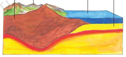
- Convergent (destructive) boundaries: Plates move toward each other. If an oceanic plate meets a continental plate, the denser oceanic plate subducts (goes under) producing deep ocean trenches and volcanoes (e.g., Andes). When two continental plates collide, they form high mountain ranges (e.g., Himalayas).
- Transform (conservative) boundaries: Plates slide past each other horizontally, causing earthquakes (e.g., San Andreas Fault in California).
Processes and effects
- Seafloor spreading builds new crust at mid-ocean ridges and pushes plates apart.
- Subduction recycles oceanic crust back into the mantle and produces volcanic arcs and earthquakes.
- Mountain building (orogeny) occurs when plates collide.
- Earthquakes and volcanoes occur mainly along plate boundaries.
Summary
Continental drift described the motion of continents. Plate tectonics explains why and how plates (including continents) move, using evidence from the ocean floor, earthquakes, volcanoes, and rock/fossil matches. This theory helps us understand where mountains, trenches, earthquakes and volcanoes form.
- Himalayas: Formed by collision between the Indian Plate and the Eurasian Plate (continental-continental convergence).
- Mid-Atlantic Ridge: A submarine mountain chain where the Eurasian and North American plates are moving apart (divergent boundary) — seafloor spreading.
- San Andreas Fault (California): A transform boundary where the Pacific Plate and North American Plate slide past each other, causing frequent earthquakes.
- Andes Mountains: Created by subduction of the Nazca Plate beneath the South American Plate (oceanic-continental convergence) and associated volcanic activity.
- East African Rift: A continental rift where the African Plate is slowly splitting, forming rift valleys and volcanic activity.
- Fossil matches (Mesosaurus, Glossopteris): Same freshwater reptile and plant fossils found in South America and Africa/Antarctica support past connection of continents.
- Basic plate speed: speed = distance / time. Use consistent units (e.g., cm/year or km/million years).
- Unit conversion: 1 cm/year = 10 km per million years (1 cm/yr × 1,000,000 yr = 10 km). Equivalently, 1 km per million years = 0.1 cm/year.
- Example calculation: If two points on the seafloor are 2000 km apart after 100 million years, rate = 2000 km / 100 Myr = 20 km/Myr = 2 cm/yr (because 20 km/Myr × 0.1 = 2 cm/yr).
Volcanoes and Earthquakes
Overview
Volcanoes and earthquakes are two of the most important surface and crustal processes driven by the internal heat and dynamics of the Earth. Both are closely linked to plate tectonics: the movement, interaction and deformation of the Earth’s lithospheric plates.
Volcanoes
- What is a volcano? — An opening or vent in Earth’s crust through which molten rock (magma), gases and ash are expelled. When magma reaches the surface it is called lava.
- Causes — Magma forms where mantle rocks melt because of decompression (mid-ocean ridges), addition of volatiles (subduction zones), or heat anomalies (hotspots).
- Types of volcanoes
- Shield volcanoes — broad, gentle slopes, low-viscosity lava (e.g., Mauna Loa, Kīlauea).
- Stratovolcanoes (composite) — steep-sided, alternate lava and ash layers, explosive eruptions (e.g., Mount Fuji, Mount St. Helens).
- Cinder cones — small, steep cones built of ash and lapilli.
- Calderas — large collapse depressions after large eruptions (e.g., Yellowstone).
- Types of eruptions — effusive (lava flows) and explosive (ash, pyroclastic flows). Explosivity depends on magma viscosity and gas content.
- Hazards — lava flows, ash fall, pyroclastic flows, volcanic gases, lahars (mudflows), long-term climate effects (ash and aerosols).
Earthquakes
- What is an earthquake? — Sudden release of energy in the Earth’s crust that creates seismic waves. Usually caused by rupture along faults when accumulated tectonic stress exceeds rock strength.
- Focus and epicenter — Focus (hypocenter) is the point within Earth where rupture starts; epicenter is the point directly above it on the surface.
- Seismic waves
- P waves (primary) — compressional, fastest, travel through solids and liquids.
- S waves (secondary) — shear, slower, travel only through solids.
- Surface waves — slower but often cause most damage (Love and Rayleigh waves).
- Causes — Most earthquakes occur along plate boundaries: transform (strike-slip), convergent (subduction & collision), divergent (ridge spreading). Intraplate quakes occur on old faults too.
- Measurement and scales
- Seismograph (seismometer) records ground motion and arrival times of P and S waves.
- Magnitude measures energy release (Richter magnitude ML historically, now Moment magnitude Mw).
- Intensity (Modified Mercalli Intensity) describes observed effects and damage at a location.
- Effects and hazards — ground shaking, surface rupture, landslides, tsunamis (if undersea), liquefaction, building collapse.
Relationship between volcanoes, earthquakes and plate tectonics
Most volcanoes and earthquakes occur at plate boundaries: subduction zones produce powerful earthquakes and island-arc volcanoes; mid-ocean ridges produce volcanic activity and shallow quakes; transform faults produce strike-slip earthquakes. Hotspots (mantle plumes) create volcanoes away from plate boundaries and can be associated with earthquake swarms.
Monitoring, prediction and preparedness
- Volcano monitoring: seismic activity, ground deformation (GPS, tiltmeters), gas emissions, thermal anomalies.
- Earthquake monitoring: global and regional seismograph networks; locating epicenters by measuring P–S arrival times at 3+ stations (triangulation).
- Preparedness: building codes, early warning systems (detect P waves to warn before stronger S/surface waves), evacuation plans, community drills.
Simple classroom activities/visuals
- Model volcano (baking soda + vinegar) to show effusive vs explosive styles (use thicker syrup for more explosive effect).
- Shake table to test building designs and simulate earthquake-resistant construction.
Key takeaway: Volcanoes and earthquakes are expressions of Earth’s internal energy and plate motions. Understanding their causes, types, measurement and hazards helps reduce risk and protect lives.
- Mount St. Helens (USA, 1980) — catastrophic explosive eruption causing pyroclastic flows and large landslides.
- Krakatoa (Indonesia, 1883) — massive volcanic eruption with global atmospheric effects and tsunamis.
- Eyjafjallajökull (Iceland, 2010) — ash cloud disrupted air travel across Europe.
- Barren Island (Andaman Sea, India) — only confirmed active volcano in India; periodic eruptions recorded in recent decades.
- 2004 Indian Ocean earthquake and tsunami — undersea megathrust earthquake (~M9.1–9.3) that produced a devastating tsunami affecting many countries.
- 2015 Nepal earthquake (Gorkha, M7.8) — powerful continental collision quake causing large loss of life and damage.
- v = d / t — Wave speed relation (useful for seismic waves). v: wave speed (km/s), d: distance (km), t: travel time (s).
- Distance to epicenter from single station using P–S time difference: D ≈ Δt × (Vp·Vs)/(Vp − Vs). With typical continental values Vp ≈ 6 km/s and Vs ≈ 3.5 km/s, this reduces to roughly D ≈ 8.4 × Δt (km). In practice seismologists use empirical travel-time curves.
- Richter local magnitude (simplified): ML = log10(A) − log10(A0(Δ)), where A is maximum amplitude of ground motion and A0(Δ) is a distance correction. (Historic formula; modern practice uses moment magnitude.)
- Energy–magnitude relation (approximate): log10 E (joules) ≈ 1.5·M + 4.8. So each whole-number increase in magnitude ≈ 32× more energy.
- Moment magnitude (Mw): Mw = (2/3)·log10(M0) − 10.7, where M0 is seismic moment in N·m. This is the modern scale tied to physical rupture size and slip.
Rocks — Definition and Importance
Definition: Rocks are natural, solid aggregates of one or more minerals that make up the Earth's crust. They occur in a variety of sizes and textures and are the basic material of the lithosphere.
Types and how they form (short):
- Igneous rocks — formed by the cooling and solidification of molten rock (magma or lava). Examples: granite (slow cooling, coarse-grained), basalt (rapid cooling, fine-grained).
- Sedimentary rocks — formed from fragments of other rocks or organic remains through weathering, erosion, deposition, compaction and cementation. Examples: sandstone, shale, limestone.
- Metamorphic rocks — formed when existing rocks are transformed by heat, pressure or chemically active fluids without melting. Examples: marble (from limestone), schist, slate (from shale).
Importance of rocks:
- Construction and infrastructure: Rocks such as granite, basalt, sandstone and limestone are used as building stones, crushed for road metal, and used in concrete and cement.
- Raw materials and industry: Many rocks supply minerals and ores (e.g., bauxite for aluminium, iron ore from banded iron formations, limestone for cement and chemical industries).
- Energy resources: Sedimentary rocks store fossil fuels (coal, petroleum and natural gas) that are vital energy sources.
- Soil formation: Weathering of rocks produces soil, determining soil type and fertility which affects agriculture.
- Water resources: Porous sedimentary rocks (like sandstone) act as aquifers, storing and transmitting groundwater.
- Preservation of history: Sedimentary rocks preserve fossils and ancient environments, helping us study Earth’s history and evolution of life.
- Landscape and cultural value: Rocks shape landforms (plateaus, mountains, plains) and many monuments and sculptures (marble statues, sandstone forts) have cultural importance.
- Environmental considerations: Rock extraction (mining, quarrying) provides resources but may cause soil erosion, habitat loss and pollution if not managed sustainably.
Summary: Rocks are the building blocks of the solid Earth; understanding their types, formation and uses is essential for resource management, construction, agriculture and studying Earth’s history.
- Granite — an igneous rock used for kitchen countertops, building facades and monuments; common in the cores of many mountains.
- Basalt — a volcanic igneous rock forming the Deccan Traps in India; used as crushed stone for roads.
- Sandstone — a sedimentary rock used in many historical buildings such as parts of the Red Fort; formed from compacted sand.
- Limestone (CaCO3) — used to make cement and lime; when metamorphosed it becomes marble (used in sculptures like the Taj Mahal's Makrana marble).
- Coal — a sedimentary rock (organic) used as a fossil fuel in power generation and industry.
- Slate — a metamorphic rock used for roofing tiles and school blackboards in the past.
- Magma (cooling & crystallisation) → Igneous rock (intrusive if slow, extrusive if fast)
- Weathering + Erosion → Sediments; Compaction + Cementation → Sedimentary rock
- Existing rock + Heat + Pressure (+ chemically active fluids) → Metamorphic rock
- Chemical example: Limestone → Calcium carbonate (CaCO3); Quartz (major mineral) → SiO2
Types of Rocks
Introduction: Rocks are natural solid materials made up of one or more minerals. The Earth’s crust is made of different kinds of rocks which are grouped into three main types depending on how they are formed: igneous, sedimentary and metamorphic. These three types are linked by the rock cycle, through processes such as melting, cooling, weathering, compaction, and heat & pressure.
1. Igneous Rocks
- How formed: From the cooling and solidification of molten rock (magma below the surface or lava on the surface).
- Types: Intrusive/plutonic (magma cools slowly underground, coarse crystals) and extrusive/volcanic (lava cools quickly at/near surface, fine crystals).
- Texture & features: Crystal size depends on cooling rate. Some are glassy (obsidian) or vesicular (pumice).
- Common examples & uses: Granite (buildings, monuments), Basalt (road stones, construction), Obsidian (tools in ancient times), Pumice (abrasives).
2. Sedimentary Rocks
- How formed: By the deposition, compaction and cementation of sediments (pieces of other rocks, minerals, organic remains) often in layers. They commonly form in water (rivers, lakes, seas).
- Types: Clastic (made of rock fragments, e.g., sandstone), Chemical (formed from minerals precipitated from solution, e.g., limestone), Organic (from remains of plants/animals, e.g., coal).
- Texture & features: Usually layered or bedded; may contain fossils; grains can be fine (shale) to coarse (conglomerate).
- Common examples & uses: Sandstone (building stone), Shale (brick making, shale gas), Limestone (cement, lime, building stone), Coal (fuel).
3. Metamorphic Rocks
- How formed: From existing rocks (igneous, sedimentary or older metamorphic rocks) changed by high heat and pressure inside the Earth, without melting.
- Types/Textures: Foliated (layered appearance from pressure, e.g., slate, gneiss) and non-foliated (no layered structure, e.g., marble, quartzite).
- Common examples & uses: Slate (roofing, tiles), Marble (sculpture, flooring), Gneiss (building stone), Schist (decorative stone).
The Rock Cycle (brief)
Rocks continuously change from one type to another through processes: melting → cooling (forms igneous), weathering/erosion → deposition → compaction/cementation (forms sedimentary), heat & pressure (forms metamorphic). Uplift and erosion expose rocks at the surface where the cycle continues.
How to identify rocks (simple clues)
- Igneous: interlocking crystals, may be glassy or vesicular.
- Sedimentary: visible layers, grains, often contains fossils.
- Metamorphic: foliated banding or recrystallized appearance.
Note for students: Observing texture, grain size, layering, presence of fossils and where the rock was found helps identify its type.
- Granite — Igneous (intrusive). Uses: building stones, monuments, countertops.
- Basalt — Igneous (extrusive). Uses: road base, construction aggregate.
- Obsidian — Igneous (volcanic glass). Historical use: cutting tools.
- Sandstone — Sedimentary (clastic). Uses: building stone, ornamental stone.
- Shale — Sedimentary (clastic). Commonly forms from mud; may contain fossils.
- Limestone — Sedimentary (chemical/organic). Uses: cement, lime, building.
- Density: ρ = mass / volume (ρ = m / V). Useful to compare rock densities (e.g., basalt is denser than granite).
- Porosity (%) = (Volume of voids / Total volume) × 100. Important for sedimentary rocks that store water or oil.
- Sedimentation rate (average) = Thickness of deposit / Time taken (e.g., mm/year).
- Bulk density = Mass of sample / Total volume (includes pore space).
Rock Cycle
What is the Rock Cycle?
The rock cycle is the continuous set of processes by which rocks are formed, changed, broken down, and reformed. It explains how the three main rock types — igneous, sedimentary and metamorphic — are related and how one type can change into another over geological time.
Main rock types and how they form
- Igneous rocks: Formed by cooling and solidification of molten rock (magma below the surface or lava on the surface). Examples: granite (intrusive), basalt (extrusive).
- Sedimentary rocks: Formed from weathered rock fragments (sediments) and remains of plants/animals that are compacted and cemented over time. Processes: weathering, erosion, transport, deposition, compaction and cementation. Examples: sandstone, limestone, shale.
- Metamorphic rocks: Formed when existing rocks are changed by heat, pressure and chemically active fluids without melting. Examples: marble (from limestone), slate (from shale), gneiss (from granite).
Key processes in the rock cycle
- Weathering & erosion: Breakdown of rocks by water, wind, ice, and biological activity; followed by transport of sediments.
- Deposition & lithification: Sediments settle in basins, are buried, compacted and cemented to become sedimentary rock.
- Heat & pressure (metamorphism): Buried rocks or rocks at convergent plate boundaries are transformed into metamorphic rocks.
- Melting & cooling: Metamorphic or any rock can melt to form magma; magma cools to form igneous rock.
Driving forces: Earth's internal heat (mantle convection, plate tectonics) and external agents (weather, water, ice, wind) power the rock cycle. Time-scales range from thousands to millions of years.
Simple conceptual summary
Rocks continuously change forms: igneous → (weathering/erosion) → sediment → (compaction/cementation) → sedimentary → (heat/pressure) → metamorphic → (melting) → magma → (cooling) → igneous. Arrows can also work in other directions (e.g., igneous directly to metamorphic under heat/pressure).
- Marble: formed when limestone (a sedimentary rock) undergoes metamorphism; used for statues and buildings (e.g., Taj Mahal uses marble).
- Slate: formed from shale (a sedimentary rock) under low-grade metamorphism; used for roofing tiles and blackboards.
- Granite: an intrusive igneous rock used in construction and monuments (e.g., kitchen countertops, building facades).
- Basalt: an extrusive igneous rock formed from lava flows; common in the Deccan Traps in India.
- Sandstone: a sedimentary rock formed from compacted sand; used in building and paving.
- Igneous --(weathering + erosion + transport + deposition)--> Sediment --(compaction + cementation)--> Sedimentary
- Sedimentary --(heat + pressure)--> Metamorphic
- Metamorphic --(melting)--> Magma --(cooling + crystallization)--> Igneous
- Igneous --(heat + pressure)--> Metamorphic
- Typical temperature ranges (approx.): metamorphism ≈ 200–800°C; melting to form magma ≈ 700–1300°C (varies with rock composition and pressure).
Minerals and Ores
Minerals and Ores
Minerals are naturally occurring, inorganic substances found in the Earth’s crust with a definite chemical composition and crystalline structure (e.g., quartz, mica, bauxite). A mineral becomes an ore when it contains a sufficient concentration of a useful metal or element that can be economically extracted (e.g., haematite is an iron ore).
Key differences
- Mineral: any natural chemical compound or element found in the crust.
- Ore: a mineral or aggregate of minerals from which a metal can be profitably extracted.
- Gangue: the non‑useful materials mixed with the ore (waste rock).
Classification
- On the basis of use: metallic minerals (iron, copper, gold) and non‑metallic minerals (limestone, mica, gypsum).
- On the basis of mode of occurrence: igneous, sedimentary and metamorphic hosted minerals (helps find deposits).
How ores are recovered and processed
- Mining: extraction from the surface (open cast) or underground mining methods depending on depth and deposit type.
- Concentration/beneficiation: removal of gangue to increase ore grade using methods such as gravity separation, magnetic separation, froth flotation, and hand picking.
- Smelting and refining: chemical and thermal processes to extract the pure metal from concentrated ore (e.g., smelting iron ore in a blast furnace).
Common ore processing methods (brief)
- Gravity separation: uses density differences to separate ore from gangue (used for gold, tin).
- Magnetic separation: removes magnetic minerals like magnetite from non‑magnetic gangue.
- Froth flotation: useful for sulphide ores (e.g., copper, lead, zinc) where chemicals make valuable minerals attach to bubbles.
Environmental and economic aspects
- Mining and processing can cause land degradation, water pollution (acid mine drainage), air pollution and loss of biodiversity.
- Conservation: recycling metals, using low‑waste technologies, land reclamation, and careful mine planning reduce impacts.
- Economic viability depends on ore grade, market price of the metal, extraction cost, and transport.
Why minerals and ores matter
Minerals and ores supply raw materials for industries (construction, transport, electronics, energy). Knowing their occurrence, extraction and conservation is important for sustainable development.
- Iron ore (haematite, magnetite) — used to make steel; major Indian states: Odisha, Chhattisgarh, Jharkhand, Karnataka.
- Bauxite — ore of aluminium; used in aluminium production; major Indian states: Odisha, Gujarat, Maharashtra.
- Copper (chalcopyrite) — used in electrical wiring and electronics; deposits in Rajasthan, Jharkhand.
- Coal — major fuel for thermal power plants and industry; found in Jharkhand, West Bengal, Odisha, Chhattisgarh (often discussed with minerals in school geography).
- Limestone — non‑metallic mineral used in cement and construction; abundant in Rajasthan, Madhya Pradesh, Chhattisgarh.
- Mica — non‑metallic mineral used in electrical insulators and cosmetics; found in Jharkhand, Bihar.
- Ore grade (%) = (Mass of metal contained in the ore / Total mass of ore) × 100
- Recovery (or Metallurgical Recovery, %) = (Mass of metal recovered after processing / Mass of metal contained in the ore) × 100
- Gangue (%) ≈ 100 − Ore grade (%) (when ore mainly consists of metal + gangue)
- Economic Reserve (simple) = Geological reserve × (Proportion recoverable × Economic factor) — a conceptual relation showing reserves depend on geology, technology and economics
Extraction and Conservation of Minerals
What are minerals? Minerals are naturally occurring substances in the Earth’s crust such as iron ore, coal, bauxite, copper, mica and limestone. They are extracted for use in industries and daily life.
Extraction of minerals (how minerals are removed):
- Surveying and exploration: Geologists locate mineral deposits using maps, drilling and sampling to estimate quantity and quality (ore grade).
- Mining methods: Two major types: surface (open-cast/open-pit) and underground (shaft, drift, slope). Surface mining is used when deposits are near the surface; underground mining is used for deep deposits.
- Processing: Extracted ore is crushed and concentrated to separate useful minerals from waste (gangue). Methods include washing, magnetic separation and flotation.
- Transport and use: Concentrated minerals are transported to factories where they are turned into products like steel, aluminium and cement.
Environmental and social effects: Mining can cause loss of forests, soil erosion, dust, water pollution and displacement of people. Acid mine drainage, land subsidence and loss of biodiversity are other impacts.
Mitigation and restoration: To reduce harm, mining companies use measures such as controlled blasting, dust suppression, proper waste disposal, water treatment and reclamation—restoring mined land by filling, leveling and planting trees.
Conservation of minerals (why and how): Minerals are non‑renewable on a human time scale. Conservation aims to use them wisely so future generations also benefit. Main strategies:
- Reduce: Use less mineral material by designing efficient products (lighter cars, less metal packaging).
- Reuse: Use products again (refillable containers, repair electronics).
- Recycle: Reprocessing scrap metal, glass and other materials saves raw mineral extraction and energy (e.g., recycling aluminium saves ~95% energy compared to new production).
- Substitution: Use alternative materials where possible (plastic or composites in some applications), but consider environmental trade-offs.
- Efficient mining and technology: Improve extraction efficiency and recovery rates to get more usable mineral from the same ore.
- Laws and planning: Government regulations, land-use planning, protected areas and environmental impact assessments (EIA) control mining to reduce damage.
Role of communities and individuals: Citizens can conserve by reducing waste, recycling, supporting sustainable products and following awareness about mineral use. Schools and industries can promote reuse and proper recycling systems.
In short, extraction provides materials for development but must be balanced with conservation practices and environmental care so minerals remain available and ecosystems are protected.
- Coal mining in the Jharia and Raniganj coalfields (Jharkhand and West Bengal) using both underground and open-cast methods.
- Iron ore extraction in Keonjhar (Odisha) and Singhbhum (Jharkhand) followed by processing into steel in nearby steel plants.
- Bauxite mining in parts of Odisha, Maharashtra and Gujarat; bauxite is processed to produce aluminium.
- Mica mining in parts of Jharkhand and Bihar for electrical insulation and cosmetics (has social and child-labour concerns).
- Recycling example: Recycling aluminium cans uses about 95% less energy than producing aluminium from bauxite and reduces the need for new mining.
- Ore grade (%) = (Mass of valuable mineral in ore / Total mass of ore) × 100
- Recoverable reserve = Total resource × Recovery factor (expressed as a decimal)
- Years of reserve = Reserves / Annual consumption (gives an estimate of how long reserves will last at current use rates)
Uses of Rocks and Minerals
What are rocks and minerals? Minerals are naturally occurring, inorganic solids with a definite chemical composition and crystal structure (e.g., quartz, mica, calcite). Rocks are aggregates of one or more minerals (e.g., granite = quartz + feldspar + mica). Both are essential raw materials for everyday life and industry.
Main uses grouped by purpose
- Construction and building: Many rocks and minerals are primary building materials. Aggregates (sand, gravel), sandstone, granite, limestone and marble are used in buildings, bridges, roads and monuments. Limestone is also used to make cement.
- Metals and manufacturing: Metal ores (iron ore — hematite, magnetite; bauxite for aluminium; copper ores) are mined and smelted to produce metals used in tools, machines, vehicles, wiring and appliances.
- Industrial minerals: Gypsum (plaster and cement), mica (electrical insulators), talc (cosmetics and paper), graphite (lubricants and pencils), kaolin (ceramics and paper) and silica (glass) have wide industrial applications.
- Energy: Coal (fossil fuel) and uranium (nuclear fuel) are mineral resources used for generating electricity.
- Agriculture and chemicals: Phosphate rock is used to make fertilisers; limestone is used to neutralise acidic soils; potash provides potassium for plant growth.
- Household and food: Halite (rock salt) for cooking; activated charcoal (from certain carbons) for purification.
- Jewellery and decorative uses: Gemstones (diamond, ruby, sapphire), marble sculptures, decorative granite and coloured minerals are used for ornaments and art.
- Abrasion and cutting: Hard minerals like corundum and diamond are used as abrasives and cutting tools.
- Technological uses: Silicon (from silica) in electronic devices; rare earth minerals in magnets, mobile phones, batteries and wind turbines.
- Ecosystem and soil formation: Weathering of rocks forms soil, releases nutrients, and influences landscape and water chemistry.
Economic and social importance: Mining and processing of rocks and minerals create jobs, contribute to industry and trade, and support infrastructure. However, extraction must be balanced with environmental protection and sustainable practices (rehabilitation of mines, recycling metals, reducing waste).
Care and conservation: Reduce unnecessary use, recycle metals and glass, use alternatives where possible, enforce responsible mining, and adopt technologies that lower environmental impact.
- Granite — used for kitchen countertops, flooring and monuments (building stone).
- Limestone — raw material for cement production and used to neutralise acidic soils in farming.
- Bauxite — processed to produce aluminium for aircraft, packaging and utensils.
- Hematite / Magnetite (iron ores) — smelted to produce iron and steel used in construction and machinery.
- Quartz (silica sand) — main ingredient for glass-making and silicon chips.
- Gypsum — used to make plaster of Paris and in construction boards (drywall).
- Density: ρ = mass / volume (units: kg·m⁻³ or g·cm⁻³). Example: density of quartz ≈ 2.65 g·cm⁻³.
- Specific gravity (SG): SG = density of mineral / density of water (water = 1 g·cm⁻³ at 4°C).
- Ore grade (metal percentage): Grade (%) = (mass of metal in ore / total mass of ore) × 100. Example: an ore containing 50 kg of copper in 1000 kg ore has grade = (50/1000)×100 = 5%.
- Carat to grams (gemstones): 1 carat = 0.2 grams.
- Mass percent of an element in a mineral: % element = (mass of element in sample / total sample mass) × 100.
Key Concepts
- Crust
- The thin, outermost solid layer of the Earth made of rocks and soil; thickness ranges from about 5 km under oceans to 70 km under continents.
- Mantle
- The thick layer of hot, semi-solid rock between the crust and the core; convection in the mantle drives plate movement.
- Core
- The central part of the Earth composed mainly of iron and nickel, with a liquid outer core and a solid inner core.
- Lithosphere
- The rigid outer shell of the Earth that includes the crust and the uppermost solid mantle.
- Asthenosphere
- The relatively soft, semi-fluid layer of the upper mantle beneath the lithosphere that allows tectonic plates to move.
- Tectonic Plate
- A large, moving slab of the Earth's lithosphere that fits together with other plates to cover the planet's surface.
- Continental Crust
- The thicker, less dense part of the Earth's crust that forms the continents; mainly composed of granitic rocks.
- Oceanic Crust
- The thinner, denser part of the Earth's crust found under the oceans; mainly composed of basaltic rocks.
- Mohorovičić Discontinuity (Moho)
- The boundary separating the Earth's crust and the mantle, identified by a sudden change in seismic wave speeds.
- Seismic Waves
- Energy waves generated by earthquakes or explosions that travel through the Earth; used to study Earth's interior.
- Hypocenter (Focus)
- The point inside the Earth where an earthquake originates and seismic energy is first released.
- Epicenter
- The point on the Earth's surface directly above the earthquake's focus (hypocenter).
- Magma
- Molten rock and dissolved gases beneath the Earth's surface.
- Lava
- Molten rock that reaches the Earth's surface during a volcanic eruption.
- Volcano
- A vent or opening in the Earth's crust through which magma, ash, and gases erupt to the surface.
- Mid-Ocean Ridge
- An underwater mountain chain where new oceanic crust is formed by volcanic activity at divergent plate boundaries.
- Ocean Trench
- A deep, narrow depression in the ocean floor formed at convergent plate boundaries where one plate bends and sinks.
- Mineral
- A naturally occurring, inorganic solid with a definite chemical composition and an ordered atomic structure.
- Rock
- A natural solid mixture of one or more minerals or mineraloids; classified as igneous, sedimentary, or metamorphic.
- Rock Cycle
- The continuous processes by which rocks are formed, broken down, and transformed between igneous, sedimentary, and metamorphic types.
End-of-Chapter Trial Paper & Test Questions
Topic-wise questions to test your understanding of every concept in this chapter.
-
Which layer of the Earth is liquid and generates the geomagnetic field? / पृथ्वी की कौन सी परत तरल है और भू-चुम्बकीय क्षेत्र उत्पन्न करती है? (a) Continental crust / महाद्वीपीय भूपर्पटी (b) Upper mantle / ऊपरी मेंटल (c) Outer core / बाह्य क्रोड (d) Inner core / आंतरिक क्रोड
Show answer
(c) — The outer core is liquid (molten iron-nickel). Convection of this liquid iron combined with Earth's rotation generates the geomagnetic field, as explained in the Core topic. / बाह्य क्रोड तरल (पिघला हुआ लोहा-निकेल) है। इस तरल लोहे का संवहन पृथ्वी के घूर्णन के साथ भू-चुम्बकीय क्षेत्र उत्पन्न करता है।
-
Continental crust is thicker than oceanic crust. Which type of crust is denser? / महाद्वीपीय भूपर्पटी महासागरीय भूपर्पटी से मोटी है। कौन सी भूपर्पटी अधिक सघन है? (a) Continental crust (~2700 kg/m³) / महाद्वीपीय भूपर्पटी (~2700 kg/m³) (b) Oceanic crust (~3000 kg/m³) / महासागरीय भूपर्पटी (~3000 kg/m³) (c) Both have the same density / दोनों का घनत्व समान है (d) Inner core / आंतरिक क्रोड
Show answer
(b) — Oceanic crust has a density of ~3000 kg/m³ (mainly basalt) while continental crust is less dense at ~2700 kg/m³ (mainly granite). This is explained in the Crust and Layers of the Earth topics. / महासागरीय भूपर्पटी (~3000 kg/m³) महाद्वीपीय भूपर्पटी (~2700 kg/m³) से अधिक सघन है।
-
Which type of rock forms when magma cools slowly underground, producing coarse-grained crystals? / किस प्रकार की चट्टान तब बनती है जब मैग्मा धीरे-धीरे भूमिगत ठंडा होता है, जिससे मोटे दाने वाले क्रिस्टल बनते हैं? (a) Sedimentary / अवसादी (b) Metamorphic / कायांतरित (c) Intrusive igneous (e.g., granite) / अनुप्रवेशी आग्नेय (जैसे ग्रेनाइट) (d) Extrusive igneous (e.g., basalt) / उत्सर्जी आग्नेय (जैसे बेसाल्ट)
Show answer
(c) — Intrusive igneous rocks like granite form when magma cools slowly underground, allowing large crystals to grow. Extrusive rocks cool quickly at the surface producing fine grains. This is in the Types of Rocks topic. / ग्रेनाइट जैसी अनुप्रवेशी आग्नेय चट्टानें तब बनती हैं जब मैग्मा धीरे-धीरे भूमिगत ठंडा होता है।
-
The boundary between the crust and the mantle is called the ________. / भूपर्पटी और मेंटल के बीच की सीमा को ________ कहते हैं।
Show answer
Mohorovičić discontinuity (Moho) / मोहोरोविचिक असातत्य (मोहो) — The Moho is the boundary between the crust and mantle, discovered using seismic wave analysis. It is described in the Introduction and Crust topics. / मोहो भूपर्पटी और मेंटल के बीच की सीमा है जो भूकंपीय तरंग विश्लेषण से खोजी गई थी।
-
In the rock cycle, sedimentary rocks are formed by the ________ and cementation of sediments over time. / चट्टान चक्र में, अवसादी चट्टानें समय के साथ अवसादों के ________ और सीमेंटीकरण से बनती हैं।
Show answer
compaction / संपीडन — Sedimentary rocks form when sediments are deposited, buried, compacted and cemented over long periods of time. This process is described in the Rock Cycle and Types of Rocks topics. / अवसादी चट्टानें तब बनती हैं जब अवसाद जमा होकर दबाव और सीमेंटीकरण से कठोर होते हैं।
-
True or False: S-waves (secondary seismic waves) can travel through both solids and liquids, which is why they pass through the outer core. / सत्य या असत्य: S-तरंगें (द्वितीयक भूकंपीय तरंगें) ठोस और तरल दोनों माध्यमों से गुज़र सकती हैं, इसीलिए वे बाह्य क्रोड से गुज़रती हैं।
Show answer
False / असत्य — S-waves can only travel through solids. They are blocked by the liquid outer core, creating an S-wave shadow zone. This fact proves the outer core is liquid. This is explained in the Introduction, Core and Layers of the Earth topics. / S-तरंगें केवल ठोस माध्यमों से गुज़र सकती हैं। वे तरल बाह्य क्रोड में अवरुद्ध हो जाती हैं।
-
Explain plate tectonics and give one example of a landform created at a convergent plate boundary. / प्लेट विवर्तनिकी की व्याख्या कीजिए और एक अभिसारी प्लेट सीमा पर बनी भू-आकृति का उदाहरण दीजिए।
Show answer
Plate tectonics is the theory that Earth's lithosphere is broken into rigid plates that move on the softer asthenosphere, driven by mantle convection. At a convergent boundary, two plates move toward each other; if both are continental, they form fold mountains. Example: The collision of the Indian Plate and the Eurasian Plate created the Himalayas. This is explained in the Plate Tectonics and Continental Drift topic. / प्लेट विवर्तनिकी का मतलब है कि पृथ्वी की भूपर्पटी कठोर प्लेटों में टूटी है जो मेंटल के संवहन से चलती हैं। उदाहरण: भारतीय प्लेट और यूरेशियन प्लेट के टकराव से हिमालय बना।
-
A rock sample has a mass of 600 g and a volume of 200 cm³. What is its density? Is this likely to be a sample of continental crust (granite ~2.7 g/cm³) or oceanic crust (basalt ~3.0 g/cm³)? / एक चट्टान के नमूने का द्रव्यमान 600 g और आयतन 200 cm³ है। इसका घनत्व क्या है? यह महाद्वीपीय भूपर्पटी (ग्रेनाइट ~2.7 g/cm³) या महासागरीय भूपर्पटी (बेसाल्ट ~3.0 g/cm³) में से किसका नमूना हो सकता है?
Show answer
Density = mass ÷ volume = 600 g ÷ 200 cm³ = 3.0 g/cm³. This density matches oceanic crust (basalt), not continental crust (granite ~2.7 g/cm³). The density formula and typical values are given in the Crust and Layers topics. / घनत्व = 600 ÷ 200 = 3.0 g/cm³। यह महासागरीय भूपर्पटी (बेसाल्ट) का घनत्व है।
Related Laws & Principles
Explore allFoundational laws & principles behind this chapter. Each one opens a full page — what it says, why it matters, five practice questions and the mistakes to avoid.