Overview
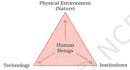
Introduction: "Resources and Development" examines how natural and human-made resources are distributed, used and managed to satisfy human needs. It defines resources, explains their classification (natural vs human-made, renewable vs non-renewable, biotic vs abiotic), and introduces the idea of sustainable development — using resources so that needs are met without compromising future generations. Importance: The chapter shows why resources are vital for economic development, livelihood security and environmental balance. It highlights problems from overexploitation (soil erosion, deforestation, water scarcity, pollution) and stresses the need for planned, equitable and sustainable resource use through technology, policy and community participation. Key themes: classification of resources; factors affecting resource development (technology, social organization, economic policies); land resources and land-use patterns; soil types and conservation; water resources, irrigation and rainwater harvesting; mineral and energy resources (conventional and non-conventional); agriculture, cropping patterns and land reforms; forests and wildlife; resource planning at national and local…
Learning Objectives
- Define the term 'resource' and distinguish between renewable, non‑renewable and potential resources with examples.
- Classify resources by origin, ownership and exhaustibility and illustrate each category with Indian examples.
- Explain the importance of resource planning in India and outline key steps involved in a national resource plan.
- Describe major land‑use categories in India and interpret recent trends and their implications for development.
- Analyze causes and consequences of land degradation and soil erosion and recommend appropriate conservation measures.
- Explain the concept and methods of watershed management and evaluate its role in sustainable resource use.
- Identify major soil types of India, state their distribution and suggest practices to maintain soil fertility.
- Explain the physical and economic factors that influence agricultural productivity and assess the impact of the Green Revolution.
Topics in this chapter
12 topics · tap a topic title to jump straight to it.
Resources - Concept and Meaning
What is a resource? A resource is any material or service which is useful to humans and can be used to satisfy human needs and wants. Resources include natural materials (water, soil, minerals), human-made goods (machines, buildings), human resources (skills, labour), and social resources (institutions, laws).
Concept and meaning
Resources are not just physical things; they become resources when humans recognise their utility and have the technology, knowledge and institutions to use them. The classification of resources depends on different criteria such as origin, exhaustibility, ownership and status of development.
Common classifications
- By origin: Natural resources (solar energy, forests), Biotic (plants, animals) and Abiotic (water, minerals).
- By exhaustibility: Renewable (solar, winds, forests if managed) and Non-renewable (coal, petroleum, minerals).
- By ownership: Individual (private land), Community (commons, village grazing land), National (public parks, rivers) and International (oceans, atmosphere).
- By status of development: Potential (undiscovered or unused), Developed (exploited and used), Reserve (identified and can be used in future), Stock (exists but not useful yet due to lack of technology).
Key features of resources
- Resources are dynamic: their status can change with new technology, social needs and values.
- Resources are unevenly distributed over space and time.
- Resources depend on human management; sustainable use is needed to maintain them for future generations.
Resource development and sustainability
Resource development includes surveying, planning, utilisation and conservation. Sustainable development aims to balance present needs with the ability of future generations to meet their needs—this requires efficient use, recycling, conservation and equitable distribution.
Why distribution is uneven? Physical factors (climate, relief, soil), historical processes (mineral formation), technological capacity and socio-economic policies determine where and how resources occur and are used.
What students should remember for exams
Be able to define resources, list classifications with examples, explain how resources change status (stock → reserve → developed), and give short examples of sustainable practices (rainwater harvesting, crop rotation, afforestation, reusing and recycling).
- Coal and petroleum — non‑renewable mineral resources used for energy; formed over millions of years and cannot be replenished quickly.
- Solar energy — a renewable resource; used for electricity through solar panels and for heating.
- Groundwater depletion in parts of northwestern India — example of over‑exploitation of a renewable resource leading to declining water tables.
- Forest management and afforestation — converting potential/undeveloped forest areas to developed reserves used sustainably for timber and biodiversity.
- E‑waste recycling — example of converting waste into usable materials, reducing pressure on non‑renewable mineral extraction.
- Per capita availability = Total quantity of a resource / Total population
- Forest cover (%) = (Area under forest / Total geographical area) × 100
- Population pressure on land = Total population / Total land area (persons per sq. km)
- Resource productivity (general) = Output obtained / Quantity of resource used
Classification of Resources
Resources are substances or objects found in nature or created by humans that satisfy human needs and wants. Classification of resources helps us understand their origin, availability, renewability and ownership, which in turn guides planning and conservation.
1. By Origin
- Biotic resources: Derived from living organisms — plants, animals and their products (forests, fisheries, livestock).
- Abiotic resources: Derived from non-living things — land, water, minerals, air.
2. By Availability (Spatial distribution)
- Ubiquitous resources: Found everywhere — air, sunlight.
- Localized resources: Found in specific places — coal, petroleum, certain minerals.
3. By Exhaustibility (Renewability)
- Renewable resources: Can be replenished naturally in a short time span — forests, fresh water (if managed), soils, solar and wind energy.
- Non-renewable resources: Limited and formed over geological time — coal, petroleum, minerals.
4. By Ownership
- Individual resources: Owned by individuals (private land, household tools).
- Community resources: Used and managed by a local community (village grazing grounds, community ponds).
- National resources: Owned and managed by the state (national parks, government mineral reserves).
- International resources: Resources beyond national jurisdiction (oceans, atmosphere, space).
5. By Stage of Development (Usefulness)
- Potential resources: Known to exist but not yet used (undiscovered groundwater, shale gas before extraction technology existed).
- Developed/Actual resources: Surveyed and currently used (active mines, irrigated land).
- Dormant resources: Present but not usable due to lack of technology or capital (uranium before nuclear tech).
- Reserve: Part of a resource that can be used with existing technology and under current economic conditions (proven oil reserves).
6. By Ownership of Use (Type)
- Natural resources: Provided by nature with little or no human alteration.
- Human-made (capital) resources: Produced by humans using natural resources (machines, buildings, infrastructure).
- Human resources: Skills, knowledge and labour supplied by people.
Importance of Classification: It helps in proper planning, sustainable use, conservation strategies, and policy making. For example, identifying a resource as non-renewable implies the need to limit consumption and find alternatives.
- Biotic resource: Forests used for timber and non-timber products (e.g., medicinal plants).
- Abiotic resource: Iron ore mined to produce steel.
- Ubiquitous resource: Solar radiation used for heating and power generation.
- Localized resource: Petroleum found in certain sedimentary basins (e.g., Middle East oil fields).
- Renewable resource: Wind energy captured by turbines along coastal areas.
- Non-renewable resource: Coal mined from a specific coalfield — finite reserves.
- Per capita resource availability = Total available resource / Population
- Resource depletion time (years) = Usable reserve / Annual consumption
- Sustainability condition (qualitative): Regeneration rate ≥ Consumption rate (for renewable resources)
- Annual resource deficit/surplus = Annual production − Annual consumption (positive = surplus, negative = deficit)
Development of Resources
What is development of resources? Development of resources means planned use and management of natural and human-made resources to increase their productivity and meet human needs in a sustainable way. It involves identifying, conserving, improving availability, and distributing resources such that present and future needs are balanced.
Key ideas:
- Identification: Survey and mapping of resources (land, water, minerals, forests, human skills).
- Conservation: Protecting resources (soil conservation, water harvesting, forest protection).
- Sustainable use: Using resources so they can renew (use renewable resources within replenishment rates; limit extraction of non-renewables).
- Equitable distribution: Planning to reduce regional disparities and ensure access for all sections of society.
- Technology and skill development: Improve resource-use efficiency through better tools, methods and education.
Factors affecting resource development
- Natural endowments (climate, topography, soil).
- Human factors (population, skills, technology, institutions).
- Economic policies, markets and infrastructure.
- Historical and cultural practices (land use patterns, traditional management).
Typical steps in resource development
- Survey & inventory (identify what exists and where).
- Planning & prioritization (which resources to develop first and how).
- Technology & capacity building (improve extraction/production and conservation methods).
- Implementation (projects: irrigation, afforestation, mining with rehabilitation).
- Monitoring & regulation (ensure sustainable extraction, environmental safeguards).
Objectives in the Indian context
- Increase agricultural productivity through irrigation, soil conservation and modern farming.
- Conserve forests and increase tree cover through afforestation and social forestry.
- Manage water resources via dams, canals, watershed management and rainwater harvesting.
- Regulate mineral extraction and promote recycling to conserve non-renewables.
- Develop human resources through education and health to use resources more effectively.
Problems in resource development
- Unequal distribution of resources across regions causes regional imbalances.
- Over-exploitation and environmental degradation (soil erosion, deforestation, pollution).
- Population pressure reduces per-capita availability.
- Poor technology, lack of funds and weak institutions hinder development.
Sustainable development is the core principle: using resources to meet present needs without compromising future generations. This requires integrated planning, community participation, technology, and appropriate laws and incentives.
- Rainwater harvesting in urban and rural homes: stores runoff and recharges groundwater, reducing dependence on external water supply.
- Watershed management in semi-arid areas (example: Ralegan Siddhi, Maharashtra): contour bunding, afforestation, and check dams increased soil moisture, groundwater and crop yields.
- Crop rotation and mixed cropping: improving soil fertility and reducing pest risks — e.g., alternating legumes with cereals to add nitrogen naturally.
- Afforestation/social forestry programmes: community-managed plantations that provide fuelwood, timber and prevent soil erosion (e.g., Joint Forest Management committees).
- Recycling and waste management: recovery of metals and plastics reduces demand for new raw materials and conserves non-renewable resources.
- Improved irrigation methods like drip irrigation: increases water-use efficiency and crop yield per unit water used.
- Per capita availability of a resource = Total resource quantity / Total population
- Land productivity (crop yield) = Total crop output (kg) / Cultivated area (hectares)
- Forest cover percentage = (Area under forest / Total geographical area) × 100
- Sustainability condition for a renewable resource: Extraction rate ≤ Natural replenishment rate
- Water-use efficiency (irrigation) = Crop yield (kg) / Volume of water used (m³)
- Energy intensity = Energy consumption / GDP (useful to measure efficiency of energy use)
Resource Planning
What is Resource Planning?
Resource planning is a systematic process of identifying, surveying and managing a region’s resources so that they are used optimally, equitably and sustainably to meet present and future needs. It ensures that natural, human-made and human resources are identified, conserved and allocated according to priority and efficiency.
Why is it needed?
- To match resources with growing population and development needs.
- To prevent over-exploitation and ensure long-term sustainability.
- To reduce regional inequalities by equitable distribution and local planning.
- To increase productivity and economic growth using limited resources optimally.
Key principles
- Sustainability: use resources at a rate that allows regeneration.
- Equity: fair distribution across regions and social groups.
- Economy and efficiency: get maximum benefit from available resources.
- Participatory approach: involve local communities and stakeholders.
- Integrated planning: coordinate land, water, forests, minerals and human resources.
Levels and steps in resource planning
- Survey and inventory: map and quantify resources (land, water, forests, minerals, human resources).
- Classification and prioritisation: identify which resources are critical and where to invest.
- Conservation and development strategies: e.g., watershed management, afforestation, soil conservation.
- Allocation and implementation: distribute resources for agriculture, industry, household use, etc.
- Monitoring and review: measure outcomes and adapt plans to changing conditions.
Challenges: limited data, regional disparities, political pressures, climate change, funding constraints and technological gaps.
- Five-Year Plans and the Planning Commission (now NITI Aayog) that prepared national-level resource allocation strategies for India.
- Watershed development and soil conservation in Ralegaon Siddhi (Maharashtra) which improved groundwater and agricultural productivity.
- Rainwater harvesting in Chennai and rooftop harvesting in many Indian cities to augment water supply and recharge groundwater.
- Joint Forest Management and community forestry projects where local people protect and manage forest resources.
- Village-level or Gram Panchayat resource planning under schemes such as MGNREGA that integrates employment with soil and water conservation.
- Rejuvenation of the Arvari river in Alwar district through community-based watershed work, restoring local water resources.
- Per capita resource availability = Total quantity of resource / Total population
- Land per person = Total arable land (hectares) / Population
- Yield per hectare = Total production (tons) / Area cultivated (hectares)
- Resource productivity = Output produced / Quantity of resource used (e.g., crop yield per unit of water)
- Resource depletion rate = (Initial stock - Current stock) / Time period
Land Resources and Land Use
Introduction
Land is a basic natural resource required for food, shelter, industry and infrastructure. It is finite, unevenly distributed and has multiple uses (agriculture, forestry, settlements, industry, pasture, wasteland, water bodies).
Classification of Land
- Agricultural land – net sown area, current fallow, other fallow, cultivable waste.
- Forest land – dense and open forests used for timber, biodiversity and ecological balance.
- Pasture and grazing land – permanent pastures and grazing lands for livestock.
- Land under non-agricultural uses – settlements, roads, industry and infrastructure.
- Wasteland – degraded lands, saline/alkaline lands, ravines, rocky areas.
- Water bodies – lakes, reservoirs, rivers and canals occupying land area.
Land Use Concepts and Terms
- Net sown area (NSA): area sown at least once in a year.
- Gross cropped area (GCA): NSA plus area sown more than once (accounts for multiple cropping).
- Cropping intensity: measure of multiple cropping = (GCA / NSA) × 100.
- Current fallow: land left without cultivation for up to one year.
- Other fallow: land left uncultivated for more than one year but less than five years.
Land Use Pattern in India (features)
- Only a part of the geographical area is under cultivation; forests, pastures, wasteland and built-up areas occupy the rest.
- Net sown area shows regional variation — dense in Indo-Gangetic plains and Peninsular plains, low in desert, highlands and forested regions.
- The proportion of land under forests is low compared to recommended levels; wasteland and degraded areas are significant.
- Intensification (multiple cropping, irrigation) has increased in some regions (e.g., Punjab, Haryana) after the Green Revolution.
Causes of Land Degradation
- Deforestation and overgrazing.
- Unsustainable farming practices (monocropping, excessive ploughing, improper irrigation causing salinity/alkalinity).
- Soil erosion by water and wind (especially on steep slopes, denuded areas).
- Industrial pollution, mining and urbanization converting fertile land to non-agricultural use.
Effects of Land Degradation
- Declining soil fertility and crop yields.
- Desertification in arid and semi-arid zones.
- Loss of biodiversity, increased floods and siltation of reservoirs.
- Reduced carrying capacity for livestock and humans; increased poverty and migration.
Land Reforms and Management (India)
- Abolition of intermediaries (e.g., zamindari), tenancy reforms, fixation of land ceilings and consolidation of holdings to increase equity and productivity.
- Watershed development, afforestation, check dams, contour bunding, terracing and shelterbelts to conserve soil and moisture.
- Promotion of sustainable agricultural practices: crop rotation, mixed cropping, organic manures, integrated nutrient management and improved irrigation techniques (drip/sprinkler).
- Land use planning and zoning — separating agricultural, industrial and residential land to reduce conflict and conserve prime farmland.
Sustainable Land Use Strategies
- Increase cropping intensity on existing agricultural land rather than expanding into forests or wastelands.
- Soil conservation measures: contour ploughing, terracing, strip cropping, cover crops and agroforestry.
- Integrated watershed management to recharge groundwater, reduce runoff and check erosion (example: successful village-level watershed projects).
- Use of technology and policy: land capability classification, remote sensing/GIS for land use mapping and monitoring, publicity of land records, land ceiling enforcement, and incentives for land restoration.
Summary
Land is a limited resource with competing uses. Sustainable land use requires correct classification, protection of forests and soil, efficient agricultural practices, land reforms and planning. Policies and local conservation measures together maintain productivity and ecological balance.
- Green Revolution (1960s–70s) in India: increased cropping intensity and yields in Punjab, Haryana and western Uttar Pradesh through high-yielding varieties, irrigation and fertilizers—illustrates intensification on existing land.
- Hiware Bazar watershed project (Maharashtra): community-based watershed management that revived groundwater, increased cropping and income—example of sustainable land and water management.
- Desertification in parts of Rajasthan (Thar): overgrazing, deforestation and improper irrigation leading to soil degradation—example of land misuse causing environmental problems.
- Land reforms after Independence (abolition of zamindari and tenancy regulation): aimed to redistribute land, reduce inequalities, and increase agricultural productivity.
- Cropping intensity (%) = (Gross Cropped Area / Net Sown Area) × 100
- Net Sown Area (NSA) = Area sown at least once in a year
- Gross Cropped Area (GCA) = Sum of area sown, counting multiple crops separately (GCA ≥ NSA)
- Per capita availability of land = Total geographical area / Total population
- Percentage of land use category (%) = (Area of that category / Total geographical area) × 100
- Crop yield per hectare = Total production (tonnes) / Area harvested (hectares)
Soil Erosion and Conservation
Introduction
Soil erosion is the removal of the topsoil layer by natural agents (water, wind, ice) or by human activities. Topsoil is the most fertile layer containing organic matter and nutrients; its loss reduces land productivity and harms the environment.
Types of soil erosion
1. Splash erosion: Soil particles are detached by raindrop impact.
2. Sheet erosion: Thin layer of soil removed uniformly over a large area.
3. Rill erosion: Small channels formed by running water.
4. Gully erosion: Large channels/gullies formed when rills deepen and widen.
5. Wind erosion: Removal of fine soil particles by strong winds (common in arid areas).
6. Mass wasting/landslides: Rapid downslope movement of soil and rock on steep slopes.
Causes
Natural factors: High rainfall intensity, steep slopes, sparse vegetation, coarse textured soils.
Human factors: Deforestation, overgrazing, over-cultivation, improper agricultural practices (e.g., ploughing up and down slope), unplanned construction, mining.
Consequences
Loss of soil fertility, reduced crop yields, sedimentation of rivers and reservoirs, increased flood risk, desertification, damage to infrastructure, and loss of biodiversity.
Soil conservation principles
Conserve soil by reducing the detaching forces (rainfall impact, runoff, wind) and by increasing soil resistance (vegetation cover, organic matter). Combine vegetative/biological methods with engineering/mechanical measures and adopt sustainable land-use practices.
Practical conservation measures
Vegetative/biological methods: Afforestation, reforestation, shelter belts/windbreaks, maintaining permanent vegetation cover, cover crops, mulching, agroforestry, controlled grazing.
Mechanical/engineering methods: Contour ploughing and contour bunding, terracing on steep slopes, check dams and silt traps in gullies, retention walls, graded bunds, percolation tanks and gully plugs to reduce runoff velocity.
Land management practices: Crop rotation, strip cropping, minimum tillage/conservation tillage, maintaining organic matter, watershed management and community participation.
Watershed approach
A watershed is an area drained by a single stream system. Integrated watershed management combines soil and water conservation, reforestation, and livelihood measures to reduce erosion, increase groundwater recharge and sustain agriculture.
Summary
Soil erosion is a serious threat to sustainable development. Simple, cost-effective measures—vegetation cover, contouring, terraces, check dams and community-led watershed management—can control erosion and restore degraded lands.
- Terrace farming in Himalayan and hilly regions (e.g., Himachal Pradesh) reduces runoff and prevents landslides by breaking a long slope into shorter, level steps.
- Shifting cultivation (jhum) in parts of Northeast India leads to removal of protective vegetation and exposes soil to heavy erosion after clearing.
- Severe gully erosion observed in some parts of the Chambal and Deccan plateau where deforestation and overgrazing have exposed soil.
- Desertification and wind erosion in parts of Rajasthan due to overgrazing, removal of vegetation and poor land management.
- Check dams and percolation tanks constructed in semi-arid parts of Maharashtra reduce runoff, trap silt and improve groundwater recharge.
- Universal Soil Loss Equation (USLE — simplified): A = R × K × LS × C × P, where A = average annual soil loss (tonnes/ha/year); R = rainfall erosivity factor; K = soil erodibility factor; LS = slope length and steepness factor; C = crop/cover factor; P = support practice factor.
- Qualitative relation often used: Soil loss ∝ Rainfall intensity × Slope steepness × (1 − Vegetation cover). (Useful for conceptual calculations; not a precise engineering formula.)
- Sediment yield (approx.): Sediment yield = Soil erosion input − On-site deposition. (Useful for watershed sediment budgeting.)
Water Resources
Overview: Water resources are sources of water that are useful to humans—surface water (rivers, lakes, reservoirs), groundwater, rainwater and glaciers. Although water is a renewable resource, it is unevenly distributed in space and time and often faces problems of scarcity and pollution.
Distribution of water on Earth
- About 97% is saline (oceans). Only about 3% is fresh water.
- Of the 3% fresh water, nearly 69% is locked in glaciers and ice caps, about 30% is groundwater, and only about 0.3% exists as surface water (lakes, rivers, wetlands) available for direct use.
Major types and uses
- Surface water: rivers and reservoirs used for irrigation, hydropower, navigation, industry and domestic supply.
- Groundwater: water stored under the ground in aquifers; tapped by wells and tube wells for drinking and irrigation.
- Rainwater: direct capture through rainwater harvesting and important for recharging aquifers.
Water resources in India (Class-10 focus)
- Rivers are grouped into major basins (Ganga, Brahmaputra, Indus, Narmada, Godavari, Krishna, Cauvery etc.). India depends heavily on monsoon rainfall to replenish surface and groundwater.
- Irrigation: Agriculture is the largest user of water (around 70%+ of total freshwater use in India), followed by industry and domestic needs.
Problems
- Uneven distribution: Seasonal (monsoon concentrated) and regional (arid vs humid regions) variability causes floods and droughts.
- Over-extraction of groundwater: falling water tables in many parts of north and west India due to excessive pumping for irrigation.
- Pollution: untreated sewage, industrial effluents and agricultural runoff degrade surface and groundwater quality.
- Loss of wetlands and deforestation in catchments reduce groundwater recharge and increase runoff.
Management and conservation
- Multipurpose river projects (dams and reservoirs) provide irrigation, hydroelectricity and flood control but may displace people and change ecosystems.
- Water-saving irrigation methods: sprinkler and drip irrigation reduce water use compared with traditional flood irrigation.
- Rainwater harvesting: rooftop and surface capture to recharge groundwater and store water for local use (widely adopted in urban areas after shortages).
- Watershed management: integrated approach including soil conservation, afforestation, check dams, percolation tanks to increase recharge and reduce runoff.
- Policy measures: inter-basin water transfers (controversial), regulation of groundwater use, pollution control and efficient pricing to encourage conservation.
Key idea for students: Sustainable use of water requires supply-side measures (reservoirs, recharge) and demand-side management (efficient irrigation, reduced pollution, behaviour change). Understanding water distribution, uses and local practices (e.g., rainwater harvesting) helps solve local water problems.
- Tehri Dam on the Bhagirathi (Uttarakhand) — multipurpose project for irrigation, hydropower and drinking water.
- Bhakra Nangal (Himachal Pradesh/Punjab/Haryana) — major irrigation and power project transforming agriculture in north-west India.
- Sardar Sarovar Project on Narmada — irrigation, drinking water and power; example of large multipurpose river projects with social-environmental tradeoffs.
- Chennai (Tamil Nadu) — after repeated water shortages, the city promoted rainwater harvesting and groundwater recharge to improve supplies.
- Punjab and Haryana — regions showing rapid groundwater decline due to intensive tube-well irrigation for paddy and wheat.
- Watershed projects in Rajasthan and Maharashtra — use check dams, percolation tanks and contour bunding to recharge groundwater and reduce soil erosion.
- Water balance (basic hydrology): P = ET + Q + ΔS (Precipitation = Evapotranspiration + Runoff + Change in storage). Use to estimate how rainfall partitions in a catchment.
- Discharge (streamflow): Q = A × v (Q = discharge, A = cross-sectional area of stream, v = average flow velocity).
- Rational method (estimate peak runoff): Q = C × i × A (Q = peak runoff rate, C = runoff coefficient (dimensionless), i = rainfall intensity, A = catchment area). Useful for small catchments and design of drains/checks.
- Per capita renewable water availability: Wpc = RWR / Population (RWR = total renewable water resources).
- Falkenmark indicator (thresholds): >1700 m3/person/year = sufficient; 1000-1700 = water stress; 500-1000 = water scarcity; <500 = absolute scarcity.
Forest and Wildlife Resources
What are Forest and Wildlife Resources?
Forests are large areas dominated by trees, shrubs and other vegetation that provide timber, fuel, fodder, medicines and ecological services (soil conservation, water regulation and climate moderation). Wildlife resources are the variety of animals, birds, insects and other organisms living in natural habitats. Both are natural resources essential for ecological balance and human welfare.
Types of forests (India context)
- Tropical evergreen forests – dense, multi-layered, near-equatorial/very high rainfall areas (Andaman & Nicobar, Western Ghats, NE India).
- Tropical deciduous forests – most widespread; moist deciduous in areas of moderate rainfall and dry deciduous where rainfall is lower.
- Thorn and scrub forests – in arid and semi-arid areas with sparse vegetation.
- Montane (temperate) forests – in Himalayan and high-altitude regions (conifers, oaks).
- Mangrove forests – found in tidal, saline coastal areas (Sundarbans).
Importance of forests and wildlife
- Support biodiversity — habitats for many species.
- Environmental services — check soil erosion, regulate rivers, recharge groundwater, sequester carbon.
- Economic benefits — timber, non-timber forest products (fruits, gums, medicinal plants), tourism.
- Socio-cultural values — livelihoods of forest-dwelling people and tribal communities.
Causes of depletion
- Deforestation for agriculture, plantations, mining and urbanisation.
- Overgrazing, illegal logging and fuelwood collection.
- Infrastructure projects (dams, roads) fragment habitats.
- Poaching and illegal wildlife trade.
Impacts of loss
- Loss of biodiversity and extinction of species.
- Soil erosion, siltation of rivers and reduced water availability.
- Micro-climate changes and increased greenhouse gases.
- Loss of livelihood for forest-dependent communities.
Conservation and management
- Protected area network: National Parks, Wildlife Sanctuaries, Biosphere Reserves (e.g., Jim Corbett, Kaziranga, Nilgiri Biosphere Reserve).
- Project Tiger, Project Elephant — species-specific protection and habitat management.
- Legislation: Forest (Conservation) Act 1980, Wildlife Protection Act 1972; anti-poaching laws.
- Afforestation and reforestation, social/participatory forestry and Joint Forest Management.
- Community conservation movements: Chipko movement (protecting trees), Van Mahotsav (planting festivals).
- Sustainable use: regulating timber extraction, promoting non-timber forest products and ecotourism.
How this links to resources and development
Forests and wildlife are renewable resources but need sustainable management. Conservation ensures long-term availability of forest products, protects ecosystem services essential for agriculture and development, and supports biodiversity-based livelihoods.
Note for students: Relate local examples from your state (protected areas, major forest types, conservation projects) and understand trade-offs between development and conservation.
- Chipko movement (1970s, Uttarakhand) — villagers hugged trees to prevent felling; a key example of community-led forest protection.
- Project Tiger — launched 1973; helped increase tiger populations in protected reserves like Ranthambore and Bandhavgarh.
- Sundarbans mangrove forests — protect coastal areas from cyclones and are habitat for the Bengal tiger.
- Kaziranga National Park (Assam) — successful conservation of the one-horned rhinoceros through strict protection and anti-poaching measures.
- Percentage forest cover = (Forest area / Total geographical area) × 100
- Per capita forest area = Forest area (ha) / Population
- Annual percent change in forest area = [(Area_end − Area_start) / Area_start] × 100
- Simpson's Diversity Index (one measure of biodiversity): D = 1 − [Σ n_i(n_i − 1) / N(N − 1)] where n_i = individuals of species i, N = total individuals
Mineral and Energy Resources
Overview
Mineral and energy resources are vital natural endowments that support industry, transport, agriculture and daily life. In CBSE Class 10 Geography (Chapter: Resources and Development) this topic covers the classification, distribution, extraction, utilisation, environmental impacts and conservation of minerals and energy resources in India and globally.
1. Classification of Minerals
- Based on occurrence: Metallic (iron, copper), non-metallic (phosphorite, mica), fuel minerals (coal, petroleum).
- Based on origin: Igneous, sedimentary and metamorphic minerals (e.g., granite, limestone).
- Based on use: Industrial minerals (gypsum), construction minerals (sand, gravel), metallic ores (bauxite, iron ore).
2. Important Minerals of India & Distribution (brief)
- Iron ore: Odisha, Chhattisgarh, Jharkhand, Karnataka. Used in steel production.
- Coal: Jharkhand, West Bengal (Raniganj, Jharia), Odisha, Chhattisgarh — major fuel for thermal power plants.
- Bauxite: Odisha, Jharkhand, Gujarat, Maharashtra — principal ore of aluminium.
- Copper: Rajasthan (Khetri), Jharkhand (Singhbhum).
- Mica: Jharkhand, Bihar — used in electronics and cosmetics.
- Petroleum & Natural Gas: Western Offshore (Mumbai High), Assam (Digboi), Gujarat (Cambay), Krishna–Godavari basin.
3. Factors Governing Location of Mineral-Based Industries
- Availability of raw materials (proximity to ore deposits).
- Power supply and water availability.
- Transport and market access (ports, railways).
- Skilled labour and industrial policy (taxes, incentives).
4. Methods of Mining
- Surface mining: Open-cast mining — used where mineral deposits are near the surface (e.g., coal, iron ore in some areas).
- Subsurface (underground) mining: Shafts and tunnels — used for deep-seated ores.
- Alluvial mining: For minerals in river deposits (e.g., placer gold).
5. Energy Resources: Types
- Conventional (exhaustible): Coal, petroleum, natural gas, nuclear energy.
- Non-conventional / Renewable (inexhaustible): Solar, wind, small hydropower, biomass, geothermal, tidal.
6. India’s Energy Scenario (high level)
- Historically coal-dominated for electricity generation; growing share of renewables (solar & wind).
- Major thermal power plants use domestic coal; major hydro projects produce bulk renewable electricity in certain states.
- Oil imports meet a large share of petroleum demand; strategic efforts to increase domestic oil & gas output and renewables.
7. Environmental Impacts
- Mining causes deforestation, soil erosion, habitat loss and water pollution from mine runoff.
- Burning fossil fuels emits greenhouse gases (CO2), particulate pollution and acid rain.
- Oil spills and gas leaks damage marine ecosystems and human health.
- Nuclear energy produces radioactive waste needing long-term management.
8. Conservation & Sustainable Use
- Energy efficiency and demand management (LEDs, efficient motors, better insulation).
- Recycling of metals (steel, aluminium) to reduce ore extraction.
- Afforestation, mine reclamation and controlled blasting to reduce mining impacts.
- Deployment of renewables (large-scale solar parks, wind farms) and distributed generation.
9. Economic Importance
- Minerals provide raw materials for industry and employment in mining regions.
- Energy availability is critical for industrial growth, transport and household needs.
- Export earnings from some minerals and refined products boost the economy.
10. Classroom/Exam Tips
- Remember major mineral-producing states and examples (iron: Odisha; coal: Jharkhand/WB; bauxite: Odisha/Gujarat).
- Distinguish between exhaustible and inexhaustible resources and list methods of conservation.
- Be able to explain environmental impacts and mitigation measures with local/real examples.
- Coal: Jharia and Raniganj coalfields (Jharkhand & West Bengal) supplying coal to thermal power plants and steel industry — causes subsidence and air pollution in local areas.
- Iron ore: Odisha’s deposits (Keonjhar-Jajpur belt) feed nearby steel plants such as those in Rourkela and Bhubaneswar region.
- Bauxite: Panchmahals (Gujarat) and Koraput (Odisha) supply raw material for aluminium plants; mining affects tribal lands and forests.
- Petroleum: Mumbai High (offshore) and Assam (Digboi) — petroleum supports transport fuels and petrochemicals; India imports significant crude oil.
- Renewables: Bhadla Solar Park (Rajasthan) and wind farms in Tamil Nadu produce large-scale clean electricity, reducing dependence on coal.
- Reserve life (years) = Total reserves / Annual extraction (consumption) — used to estimate how long a resource will last at current extraction rates.
- Ore grade (%) = (Mass of metal in ore / Mass of ore) × 100 — indicates concentration and economic viability of mining.
- Energy density (useful for comparisons) = Energy content / Mass or Volume (e.g., coal kcal/kg, petrol MJ/L).
- Capacity factor (power plant) = (Actual energy produced over period) / (Installed capacity × Time period) — shows utilisation of generation capacity.
Sustainable Development
Definition: Sustainable development means meeting the needs of the present generation without compromising the ability of future generations to meet their own needs. It balances economic growth, social equity and environmental protection.
Why it is needed: Rapid population growth, unequal resource distribution, over-exploitation of natural resources and environmental degradation make it necessary to use resources wisely so that resources remain available for the future.
Three pillars:
- Economic: Efficient use of resources, stable livelihoods and equitable growth.
- Social: Poverty reduction, access to basic services (education, health), and social inclusion.
- Environmental: Conserving ecosystems, controlling pollution and maintaining biodiversity.
Principles of sustainable development:
- Intergenerational equity — fairness between current and future generations.
- Precautionary principle — prevent damage when there is uncertainty.
- Polluter pays — those who cause pollution should bear the costs.
- Conservation and efficient use — reduce, reuse, recycle; use renewable resources within their regeneration rates.
Practical strategies:
- Sustainable agriculture: Crop rotation, organic farming, mixed cropping to maintain soil fertility and reduce chemical use.
- Water management: Rainwater harvesting, groundwater recharge, efficient irrigation (drip and sprinkler) and watershed management.
- Energy: Promote renewables (solar, wind, small hydro), improve energy efficiency, and reduce fossil-fuel dependence.
- Forestry and biodiversity: Afforestation, community forest management, protection of habitats and corridors.
- Urban planning: Compact cities, public transport, waste management, green spaces and building efficiency.
Outcomes we aim for: Stable ecosystems, sustained resource availability, improved quality of life, reduced poverty and resilient economies.
- Chipko Movement (India) — community-based forest protection where people hugged trees to prevent felling, highlighting local involvement in conserving forests.
- Rainwater harvesting in Chennai and traditional johads in Rajasthan — capturing and recharging groundwater to provide water sustainably.
- Sikkim becoming India’s first fully organic state — banning synthetic pesticides and promoting sustainable agriculture.
- Costa Rica’s forest-restoration and payment-for-ecosystem-services programs — reversing deforestation while developing eco-tourism.
- Germany’s Energiewende policies — large-scale investment in renewable energy and energy efficiency to reduce fossil-fuel use.
- Community fisheries with regulated quotas — harvesting fish at or below the annual sustainable yield to avoid stock collapse.
- Per capita resource use = Total resource consumed / Population
- Ecological footprint per capita = (Biologically productive area required to support consumption) / Population
- Per capita carbon emissions = Total CO2 emissions / Population
- Sustainable harvest principle: Annual harvest ≤ Annual natural growth (sustainable yield). (No single numeric formula needed at class 10 level.)
- Energy intensity = Total energy consumed / GDP (lower values indicate more efficient use of energy for economic output)
Resource-Environment Linkages and Management Issues
What are resource–environment linkages? Resource–environment linkages describe how natural resources (land, soil, water, minerals, forests, flora and fauna, air, energy) and the environment interact. Resources are produced by the environment and, in turn, human use of resources changes environmental conditions (land-use change, pollution, biodiversity loss). Sustainable development depends on managing these linkages so resources meet present needs without undermining future availability.
Key concepts
- Types of resources: renewable (forests, soil, water, biomass) and non‑renewable (minerals, fossil fuels).
- Resource availability: depends on natural endowment, technology, economic access, and population pressure.
- Sustainable use: using resources at a rate that allows natural regeneration and maintains ecosystem services.
- Carrying capacity: the maximum population or use level an environment can sustain without degradation.
How resource use affects the environment
- Overexploitation: excessive groundwater withdrawal lowers water tables; overfishing reduces fish stocks.
- Land-use change: conversion of forests to agriculture or urban areas leads to soil erosion, loss of carbon sinks, and biodiversity decline.
- Pollution: industrial, agricultural (pesticide, fertilizer runoff), and municipal wastes contaminate air, water and soils.
- Climate linkages: burning fossil fuels increases greenhouse gases, altering climate and affecting resource productivity (e.g., crop yields, water availability).
Major management issues
- Unequal distribution and access: resources may be plentiful but inaccessible to poorer groups, causing social conflict and unsustainable local exploitation.
- Depletion of renewable resources: when extraction > regeneration (groundwater mining, deforestation).
- Pollution and degradation: soil salinisation, acidification, river pollution, air pollution in cities.
- Loss of biodiversity: habitat destruction and fragmentation reduce species diversity and ecosystem resilience.
- Institutional and governance gaps: weak enforcement, poor planning, and conflicting policies hinder effective resource management.
- Population growth and urbanisation: increased demand for land, water, energy and services intensifies pressure on resources.
Management strategies
- Conservation and protection: protected areas, afforestation, soil conservation (contour bunding, terracing), and watershed management.
- Efficient use and technology: drip irrigation, precision farming, energy‑efficient appliances, cleaner fuels and renewable energy (solar, wind).
- Policy and legal measures: environmental laws (pollution control, forest conservation), economic instruments (subsidy reforms, pollution taxes), and land‑use planning.
- Community participation: joint forest management, local water user groups, traditional resource management practices.
- Restoration and rehabilitation: reforestation, wetland restoration, soil reclamation and treatment of polluted sites.
- Awareness and education: public campaigns, school education and stakeholder engagement to change consumption patterns.
Why linkages matter for development — Resource management is central to sustainable development: balanced use secures food, water, energy and livelihoods while conserving ecosystem services that underpin long‑term prosperity.
- Groundwater depletion in north‑western India (Punjab, Haryana): high irrigation demand for paddy/wheat causing falling water tables; managed by policies promoting crop diversification and micro‑irrigation.
- Deforestation and soil erosion in Himalayan foothills: conversion of forest to agriculture and unplanned construction increases landslides and loss of soil fertility; addressed by afforestation and regulated land use.
- Urban air pollution in Delhi: vehicle and industrial emissions causing smog and health impacts; management includes emission standards, public transport expansion, and odd‑even vehicle schemes.
- Chipko movement (1970s): a community forest protection movement where villagers hugged trees to prevent logging — an example of grassroots conservation.
- Rainwater harvesting in Chennai: municipal regulations and rooftop systems helped recharge groundwater after severe water shortages.
- River pollution in the Ganga: discharge of domestic and industrial waste degrading water quality; national and state level programmes aim at sewage treatment and river cleaning.
- Per capita resource availability = Total resource / Population
- Resource depletion rate (simple) = (Consumption rate − Natural replenishment rate) per unit time
- Renewability condition (qualitative): Sustainable use if Consumption rate ≤ Regeneration rate
- Carrying capacity (conceptual): K relates to available resources and technology; population growth beyond K leads to resource stress
Major Programmes, Policies and Community Actions in India
Overview: India faces challenges of uneven resource distribution, soil erosion, deforestation, water scarcity and land degradation. To manage resources sustainably the government has launched policies and programmes and citizens have taken community actions. These aim at conservation, equitable use, improving productivity and regenerating degraded ecosystems.
Major National Policies & Acts
- National Water Policy (adopted / revised periodically): provides guidelines for integrated water resources management, priority use (drinking, irrigation, industry) and demand-side measures.
- National Forest Policy (1988) and Forest Conservation Act (1980): aim to increase forest/tree cover, promote sustainable forest management and regulate diversion of forest land.
- Wildlife Protection Act and protected area policies: conserve biodiversity and habitats.
- MGNREGA (Mahatma Gandhi National Rural Employment Guarantee Act): provides 100 days of rural employment, often used for creating water-harvesting structures, soil conservation and afforestation works.
- Pradhan Mantri Krishi Sinchai Yojana (PMKSY): aims at enhancing irrigation coverage and efficient water use (e.g., drip & sprinkler irrigation).
Major Programmes & Schemes
- Watershed Development Programmes (e.g., Integrated Watershed Management Programme): focus on soil and water conservation, check dams, contour bunding and community participation to restore degraded catchments.
- Afforestation and Social Forestry: plantation drives, community nurseries, shelterbelts to increase green cover and supply fuelwood without degrading natural forests.
- Soil Conservation Works: terrace farming, contour ploughing, vegetative barriers, gully plugs to reduce erosion and improve fertility.
- Rainwater Harvesting & Groundwater Recharge: rooftop harvesting, percolation tanks and recharge wells to raise groundwater levels.
- Energy Efficiency & Renewable Promotion: programmes promoting solar pumps, clean cookstoves and energy conservation to reduce pressure on biomass and fossil fuels.
Community Actions & Movements
- Chipko Movement (Uttarakhand): villagers, especially women, hugged trees to prevent felling — a landmark forest conservation movement emphasizing community stewardship.
- Appiko Movement (Karnataka): modelled on Chipko, it protected Western Ghats forests through local action.
- Silent Valley Movement (Kerala): civil society action to protect a tropical evergreen forest from a hydroelectric project.
- Model villages such as Ralegaon Siddhi and Hiware Bazar: used watershed management, strict local rules and MGNREGA projects to revive water tables, increase cropping intensity and raise incomes.
- Joint Forest Management (JFM): partnerships between local communities and forest departments to manage and benefit from forests sustainably.
How these measures help (mechanisms)
- Conservation of soil and water increases agricultural productivity and reduces vulnerability to droughts.
- Community management (JFM, local watershed committees) ensures local knowledge, enforcement of rules and shared benefits — improving long-term sustainability.
- Employment-linked schemes (MGNREGA) create durable assets (check dams, farm ponds) while providing income.
- Policy frameworks (water, forest, environment) set national priorities and legal backing for local actions.
Challenges: Implementation gaps, conflicts over land and water, inadequate funding or technical support, short-term focus of some programmes and pressure from developmental projects (dams, mining) that can damage local resources.
Conclusion: Sustainable resource management in India requires a mix of well-designed policies, effective programmes, community participation and local stewardship. Successful cases (Ralegaon Siddhi, Chipko, JFM) show that combining scientific measures with social mobilization yields durable results.
- Chipko Movement (1970s, Uttarakhand): villagers hugged trees to prevent felling — led to greater awareness and policy attention to forest conservation.
- Ralegaon Siddhi (Maharashtra): watershed management, strict local rules and use of MGNREGA/work programmes revived groundwater and transformed agriculture.
- Hiware Bazar (Pune district): community watershed projects and water harvesting increased cropping intensity and income.
- MGNREGA works: construction of check dams, farm ponds and soil conservation structures across drought-prone districts to improve water availability and livelihoods.
- Joint Forest Management: communities in several states manage forest patches, leading to increased regeneration and shared benefits from non-timber forest products.
- Silent Valley (Kerala): public protest stopped a hydroelectric project, saving a unique evergreen forest ecosystem.
- Per capita resource availability = Total resource quantity / Total population
- Population density = Total population / Area (persons per sq. km)
- Land availability per person = Total land area / Total population (hectares per person)
- Crop yield per hectare = Total crop production / Area cultivated (tonnes per hectare)
- Percentage of forest cover = (Forest area / Geographical area) × 100
- Net sown area percentage = (Net sown area / Total reporting area) × 100
Key Concepts
- Resource
- Anything that satisfies human needs and wants and can be used for human benefit.
- Natural Resource
- Resources that occur in nature and are used by humans with little modification.
- Human Resource
- The skills, knowledge, labor and creativity of people that contribute to production.
- Human-made Resource
- Objects or infrastructure created by humans to enhance natural resources or meet needs.
- Renewable Resource
- Resources that can be replenished naturally over a short period if used sustainably.
- Non-renewable Resource
- Resources available in fixed amounts that cannot be replenished in a human timescale.
- Potential Resource
- Resources whose existence is known but are not yet used due to lack of technology or investment.
- Developed Resource
- Resources that have been surveyed, their quantity and quality assessed and are being used.
- Stock
- Quantity of a resource present in the environment that may or may not be used currently.
- Sustainable Development
- Development that meets present needs without compromising the ability of future generations to meet theirs.
- Resource Planning
- Systematic assessment and management of resources to ensure their optimal and equitable use.
- Conservation
- Protection, careful management and restoration of resources to prevent depletion and degradation.
- Land Use
- The different ways in which people utilize land for activities like agriculture, industry and settlement.
- Soil Erosion
- Removal of the top fertile layer of soil by wind, water or human activity.
- Deforestation
- Clearing or removal of forests for agriculture, logging or urban expansion.
- Biodiversity
- The variety of living organisms in an area, including species, genetic and ecosystem diversity.
- Rainwater Harvesting
- Collecting and storing rainwater for reuse to reduce dependence on other water sources.
- Mineral Resource
- Naturally occurring inorganic substances extracted from the earth for economic use.
- Carrying Capacity
- Maximum number of individuals or level of activity that an environment can sustain without degradation.
- Desertification
- Process by which fertile land becomes desert due to drought, deforestation or inappropriate land use.
End-of-Chapter Trial Paper & Test Questions
Topic-wise questions to test your understanding of every concept in this chapter.
-
Define a resource and explain why something becomes a resource only when humans recognise its utility. / संसाधन को परिभाषित करें और समझाएँ कि कोई वस्तु संसाधन तभी क्यों बनती है जब मनुष्य उसकी उपयोगिता को पहचानते हैं।
Show answer
A resource is any material or service useful to humans that can satisfy needs and wants; something becomes a resource only when humans recognise its utility and have the technology, knowledge and institutions to use it, which is why resource status is dynamic and changes with technology and values. / संसाधन कोई भी ऐसी सामग्री या सेवा है जो मनुष्यों के लिए उपयोगी हो और आवश्यकताओं तथा इच्छाओं को पूरा कर सके; कोई वस्तु संसाधन तभी बनती है जब मनुष्य उसकी उपयोगिता पहचानें और उसका उपयोग करने हेतु तकनीक, ज्ञान व संस्थाएँ हों, इसीलिए संसाधन की स्थिति गतिशील होती है और तकनीक व मूल्यों के साथ बदलती है।
-
Distinguish between renewable and non-renewable resources, giving two Indian examples of each. / नवीकरणीय और अनवीकरणीय संसाधनों में अंतर बताएँ तथा प्रत्येक के दो भारतीय उदाहरण दें।
Show answer
Renewable resources can be replenished naturally in a short span if managed (e.g. solar energy, forests), while non-renewable resources are finite and formed over geological time (e.g. coal, petroleum). / नवीकरणीय संसाधन उचित प्रबंधन से अल्प अवधि में प्राकृतिक रूप से पुनः भर जाते हैं (जैसे सौर ऊर्जा, वन), जबकि अनवीकरणीय संसाधन सीमित होते हैं और भूगर्भीय काल में बनते हैं (जैसे कोयला, पेट्रोलियम)।
-
Why is resource planning essential in India? State any two reasons. / भारत में संसाधन नियोजन क्यों आवश्यक है? कोई दो कारण बताएँ।
Show answer
Resource planning is essential to use resources optimally, equitably and sustainably; two reasons are that resources are unevenly distributed across regions (requiring balanced development) and that planning prevents over-exploitation and ensures long-term sustainability for a growing population. / संसाधन नियोजन संसाधनों के अनुकूलतम, न्यायसंगत और सतत उपयोग के लिए आवश्यक है; दो कारण हैं कि संसाधन क्षेत्रों में असमान रूप से वितरित हैं (संतुलित विकास हेतु) और नियोजन अति-दोहन रोककर बढ़ती जनसंख्या के लिए दीर्घकालिक सततता सुनिश्चित करता है।
-
Define cropping intensity. If the Gross Cropped Area is 150 hectares and the Net Sown Area is 100 hectares, calculate it. / फसल सघनता को परिभाषित करें। यदि सकल बोया गया क्षेत्र 150 हेक्टेयर और निवल बोया गया क्षेत्र 100 हेक्टेयर है, तो इसकी गणना करें।
Show answer
Cropping intensity measures multiple cropping and equals (Gross Cropped Area / Net Sown Area) × 100 = (150 / 100) × 100 = 150%, meaning land is cropped 1.5 times a year on average. / फसल सघनता बहु-फसल को मापती है और (सकल बोया गया क्षेत्र / निवल बोया गया क्षेत्र) × 100 = (150 / 100) × 100 = 150% के बराबर है, अर्थात भूमि औसतन वर्ष में 1.5 बार बोई जाती है।
-
Explain any three human-induced causes of land degradation in India. / भारत में भूमि-निम्नीकरण के कोई तीन मानव-जनित कारण समझाएँ।
Show answer
Three human causes are deforestation and overgrazing which expose soil; unsustainable farming such as monocropping and improper irrigation that causes salinity/alkalinity; and industrial pollution, mining and urbanisation that convert fertile land to non-agricultural use. / तीन मानव-जनित कारण हैं वनोन्मूलन और अतिचारण जो मृदा को अनावृत करते हैं; अस्थिर कृषि जैसे एकल-फसल और अनुचित सिंचाई जो लवणता/क्षारीयता उत्पन्न करती है; तथा औद्योगिक प्रदूषण, खनन और शहरीकरण जो उपजाऊ भूमि को गैर-कृषि उपयोग में बदल देते हैं।
-
What is watershed management and how does it support sustainable resource use? / जल-संभर प्रबंधन क्या है और यह सतत संसाधन उपयोग का समर्थन कैसे करता है?
Show answer
A watershed is an area drained by a single stream system, and integrated watershed management combines soil and water conservation, afforestation and check dams; it supports sustainability by reducing soil erosion and runoff, increasing groundwater recharge and sustaining agriculture, as seen in projects like Hiware Bazar and Ralegan Siddhi. / जल-संभर एक एकल जलधारा-तंत्र द्वारा अपवाहित क्षेत्र है, और एकीकृत जल-संभर प्रबंधन मृदा व जल संरक्षण, वनरोपण और चेक डैम को जोड़ता है; यह मृदा अपरदन व अपवाह घटाकर, भूजल पुनर्भरण बढ़ाकर और कृषि को बनाए रखकर सततता का समर्थन करता है, जैसा हिवरे बाज़ार और रालेगण सिद्धि जैसी परियोजनाओं में देखा गया।
-
Name any two major soil-conservation measures and briefly explain how each controls erosion. / कोई दो प्रमुख मृदा-संरक्षण उपाय बताएँ और संक्षेप में समझाएँ कि प्रत्येक अपरदन को कैसे नियंत्रित करता है।
Show answer
Contour ploughing/bunding ploughs along contours to slow runoff and reduce water erosion on slopes, while terracing breaks a long slope into shorter level steps that reduce runoff velocity and prevent landslides; both increase soil resistance and reduce the detaching force of running water. / समोच्च जुताई/मेड़बंदी समोच्च रेखाओं के साथ जुताई कर अपवाह को धीमा करती है और ढलानों पर जल अपरदन घटाती है, जबकि सीढ़ीदार खेती लंबी ढलान को छोटे समतल चरणों में बाँटती है जो अपवाह वेग घटाती है और भूस्खलन रोकती है; दोनों मृदा प्रतिरोध बढ़ाते हैं और बहते जल के पृथक्करण-बल को कम करते हैं।
-
Of the Earth's total water, how much is fresh and accessible as surface water, and why does this make water conservation important? / पृथ्वी के कुल जल में से कितना ताज़ा है और सतही जल के रूप में सुलभ है, तथा यह जल संरक्षण को क्यों महत्वपूर्ण बनाता है?
Show answer
About 97% of water is saline and only about 3% is fresh; of this fresh water nearly 69% is locked in glaciers and 30% is groundwater, leaving only about 0.3% as accessible surface water, so the very small usable fraction combined with uneven distribution and pollution makes conservation essential. / लगभग 97% जल खारा है और केवल लगभग 3% ताज़ा है; इस ताज़े जल का लगभग 69% हिमनदों में बंद है और 30% भूजल है, जिससे केवल लगभग 0.3% ही सुलभ सतही जल बचता है, इसलिए अत्यल्प उपयोगी अंश के साथ असमान वितरण और प्रदूषण जल संरक्षण को अनिवार्य बनाते हैं।
Related Laws & Principles
Explore allFoundational laws & principles behind this chapter. Each one opens a full page — what it says, why it matters, five practice questions and the mistakes to avoid.