Overview
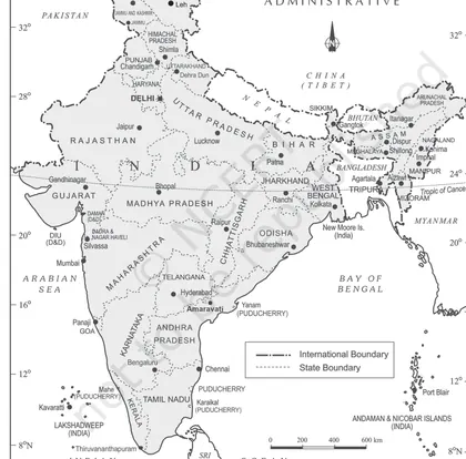
Introduction: India — Location examines where India is positioned on Earth (absolute and relative location), its latitudinal and longitudinal extent, and the implications of this position for climate, day length, biodiversity and strategic relations. The chapter locates India in global and regional contexts and introduces concepts such as hemispheres, standard meridian and Tropic of Cancer. Importance: Understanding India’s location is fundamental to explaining its climate (especially the monsoon), variations in temperature and daylight, patterns of vegetation and agriculture, time calculation (Indian Standard Time), trade and maritime significance, and geopolitical relations with neighbouring countries. Key themes: - Absolute location: latitudinal extent (8°4' N to 37°6' N for the mainland; southernmost and northernmost limits as given in the text) and longitudinal extent (68°7' E to 97°25' E). - Hemispheres: India lies in the Northern and Eastern hemispheres. - Tropic of Cancer (23°30' N) and its climatic significance. - Standard Meridian of India (82°30' E; Indian Standard Time = GMT +5:30) and the time difference between eastern and western extremes (~1 hour 50–57 minutes,…
Learning Objectives
- Define India's geographical coordinates and state its latitudinal and longitudinal extent.
- Locate and mark on a map the Tropic of Cancer, Standard Meridian (82°30' E), and outline India's mainland and island groups.
- Explain the significance of India's latitudinal and longitudinal extent for climate, day length, and time calculation.
- Calculate time differences between Indian Standard Time and Greenwich Mean Time and between two given longitudes in India.
- Identify India's neighbouring countries and describe the nature and length of major land boundaries.
- Describe the importance of India's coastal location and major ports for trade and maritime activities.
- Analyze the strategic significance of India's location in South Asia and the Indian Ocean for geopolitical relations.
- Compare the climatic implications of India's position between the Tropic of Cancer and the equator for temperature and vegetation zones.
Topics in this chapter
8 topics · tap a topic title to jump straight to it.
Location: Absolute and Relative
Absolute location is the exact position of a place on the Earth's surface expressed by a coordinate system — usually latitude and longitude. Absolute location answers the question: "Where is it precisely?" Example formats: 28.6139°N, 77.2090°E (New Delhi).
Relative location describes a place in relation to other places, physical features or directions (e.g., north of, between, along). It answers: "Where is it with respect to other places and why does that matter?" Example: India lies south of the Himalayas and north of the Indian Ocean; it is between West Asia and Southeast Asia.
Why both matter: Absolute location provides precise mapping, navigation and calculation (time zones, distances). Relative location explains regional interactions — trade routes, climate influence, strategic and cultural links.
Key points about India (as a worked example):
- Absolute (extent): India lies roughly between 8°4'N and 37°6'N latitude and 68°7'E and 97°25'E longitude.
- Standard Meridian for India: 82°30'E (used to calculate Indian Standard Time).
- Relative: India is bounded by the Himalayas to the north and the Indian Ocean to the south; it neighbours Pakistan, China, Nepal, Bhutan, Bangladesh and Myanmar.
Practical uses & implications: Absolute location is used for navigation, satellite mapping, distance computation and time calculation. Relative location helps explain climate influences (monsoon paths), geopolitical relationships (neighbouring countries), transport corridors and economic links.
Notes on precision: Latitude measures north–south position (0° at Equator to 90° at poles). Longitude measures east–west position (0° at Prime Meridian up to 180°). Coordinates are usually given in degrees (°), minutes (') and seconds ('') or in decimal degrees.
- Absolute location of New Delhi: 28.6139°N, 77.2090°E. Absolute location of Mumbai: 19.0760°N, 72.8777°E.
- India's absolute extent: approximately 8°4'N to 37°6'N latitude and 68°7'E to 97°25'E longitude.
- Relative location: India is south of the Himalayas, north of the Indian Ocean, west of Myanmar and Bangladesh, and east of Pakistan. This relative position makes India a bridge between East and West Asia.
- Time example: Indian Standard Time (IST) is based on the absolute longitude 82°30'E. Since each degree of longitude equals 4 minutes of time, 82.5° × 4 min = 330 minutes = 5 hours 30 minutes ahead of UTC.
- 1° latitude ≈ 111 km (constant).
- 1° longitude ≈ 111 km × cos(φ) where φ = latitude (varies with latitude).
- Time difference (minutes) = 4 × difference in longitude (degrees). Example: difference of 15° longitude = 60 minutes (1 hour).
- Distance between two points (Haversine formula): a = sin²(Δφ/2) + cos φ1 × cos φ2 × sin²(Δλ/2) c = 2 × atan2(√a, √(1−a)) distance = R × c (R ≈ 6371 km, φ in radians, λ in radians).
- Approximate flat-earth method for short distances: north–south distance ≈ Δφ (degrees) × 111 km east–west distance ≈ Δλ (degrees) × 111 × cos(mean latitude) km straight-line ≈ √(NS² + EW²)
Latitudinal Extent and Significance
Definition and range
Latitudinal extent means the north–south span of a country measured by the difference in latitude between its southernmost and northernmost points. India extends approximately from 8°4'N (Kanyakumari, southern tip) to 37°6'N (northernmost point in the Himalaya region), a latitudinal difference of about 29°02' (~29.03°).
Calculation (how the span is converted to distance)
One degree of latitude ≈ 111 km (mean value). So the north–south linear extent ≈ (37°6' − 8°4') × 111 km ≈ 29.033° × 111 km ≈ ~3,220 km (commonly quoted as about 3,200 km).
Important latitude line
The Tropic of Cancer (approx. 23°30'N) crosses India roughly through its middle and separates most of India into tropical (south of the Tropic) and subtropical (north of the Tropic) climatic belts.
Significance
- Climatic variation: Large latitudinal span produces strong climatic zonation — tropical climates in peninsular India, subtropical and temperate conditions in northern plains and Himalayan foothills. This leads to diversity in temperature, precipitation patterns and seasons across the country.
- Vegetation and biodiversity: Different latitudes support different natural vegetation — tropical evergreen/southern moist forests, deciduous forests in central India, dry thorn forests and temperate forests in the north. Latitudinal variation contributes to India’s wide biodiversity gradients.
- Agriculture and crops: Crop distribution follows climatic belts that are latitudinally controlled — rice and coconut thrive in the humid tropical south and east, wheat and rabi crops dominate the cooler north and north-west, tea grows in specific northern/eastern highlands with suitable latitudinal-climatic combination.
- Solar radiation and energy potential: Insolation (sun-angle and duration) varies with latitude. Southern India (closer to the equator) receives higher average solar intensity year-round, important for solar power siting.
- Day-length and seasonal effects: Difference in day-length and solar altitude across latitudes affects growing seasons, heating/cooling needs and human activities. Northern India experiences greater seasonal contrast than southern India.
- Human settlement and economy: Climate-linked habitability, crop zones and resource distribution influence population distribution, occupation and regional economies — e.g., intensive agriculture in the fertile northern plains, plantation crops in parts of the south and northeast.
- Strategic and administrative implications: Long north–south extent affects defence logistics, communication networks and planning (single IST for the whole country causes earliest sunrises in the east and late sunsets in the west), and demands region-specific policies.
Summary
India’s latitudinal extent (≈8°4'N to 37°6'N, ~29°) is a chief reason for its climatic, ecological and agricultural diversity and has implications for energy, settlement, and strategic planning.
- Geographic endpoints: Kanyakumari (approx. 8°4'N) in the south and northernmost point in the Indian Himalaya (approx. 37°6'N) illustrate the latitudinal span.
- Climate contrast: Tropical coastal Kerala (south) supports coconut and rubber cultivation, while temperate Kashmir (north) supports apple orchards and experiences snowfall.
- Agriculture: Wheat cultivation predominates in the cooler latitudes of north-west India; rice and millets are more common in tropical and sub-tropical latitudes of eastern and southern India.
- Solar energy: Southern states (closer to the equator) have more consistent high solar insolation, favorable for photovoltaic installations compared with higher latitudes.
- Tropic of Cancer influence: The Tropic (~23°30'N) passes through central India and marks a rough divide between tropical and subtropical climates within the country.
- Convert latitudes in degrees and minutes to decimal degrees: decimal° = degrees + (minutes / 60). Example: 8°4' = 8 + (4/60) = 8.0667°.
- North–south linear distance (approx.): distance (km) = latitude difference (°) × 111 km/°. Example: 29.033° × 111 ≈ 3,220 km.
- Solar altitude at local solar noon (approx.): h = 90° − |latitude − solar declination|. (Use solar declination for the day, e.g., ≈ +23.5° at summer solstice.)
Longitudinal Extent, Standard Meridian and Indian Standard Time (IST)
Longitudinal extent
India extends approximately from 68°7'E (Guhar Moti, Gujarat) to 97°25'E (Kibithu, Arunachal Pradesh). The longitudinal spread is 97°25' − 68°7' = 29°18' (29.3°). Because Earth rotates 360° in 24 hours, every 1° of longitude equals 4 minutes of time. Thus the solar time difference between India’s extreme longitudes is 29.3° × 4 = 117.2 minutes, i.e. 1 hour 57 minutes 12 seconds. This is the natural (local solar) time difference across the country.
Standard Meridian
To avoid numerous local times across a large country, India uses a single standard meridian: 82°30'E (82.5°E). This meridian passes near Mirzapur in Uttar Pradesh and was chosen because it lies roughly centrally within India’s longitudinal extent, minimizing the maximum deviation of local solar time from the national standard.
Indian Standard Time (IST)
IST is defined by the mean solar time at the standard meridian 82°30'E. Converting longitude to time: 82.5° × 4 minutes/° = 330 minutes = 5 hours 30 minutes. Therefore IST = UTC (GMT) + 5:30. All official civil time across India follows IST.
Consequences and practical effects
Because the country spans almost 2 hours of solar time but uses a single time, sunrise and sunset occur much earlier (relative to clock time) in the eastern states than in the west. For example, when clocks show 6:00 AM IST, solar time in eastern Arunachal may be close to 6:60 (i.e. ~6:59:40) while in far-west Gujarat solar time may be about 5:02:28—hence differences in daylight usage, work schedules, and discussions about energy efficiency and school/work timings. Proposals such as multiple time zones or adjusted local schedules are sometimes suggested to reduce these inefficiencies.
How to compute local time and differences
Use the relation that every 1° longitude = 4 minutes. For any longitude λ (degrees east), local mean time = UTC + (λ × 4 minutes). The difference between two places equals Δλ × 4 minutes.
- Time difference between India’s extremes: Δλ = 97°25' − 68°7' = 29°18' = 29.3°. Time difference = 29.3 × 4 = 117.2 minutes = 1 hour 57 minutes 12 seconds.
- Local solar time at western extreme (68°7'E): UTC + (68.1167 × 4) = UTC + 272.4668 min = UTC + 4h 32m 28s. Compared to IST (UTC + 5h 30m), local solar time is behind IST by 57 minutes 32 seconds.
- Local solar time at eastern extreme (97°25'E): UTC + (97.4167 × 4) = UTC + 389.6668 min = UTC + 6h 29m 40s. Compared to IST, local solar time is ahead of IST by 59 minutes 40 seconds.
- Time difference (minutes) = Difference in longitude (degrees) × 4
- Local mean time at longitude λ (°E) = UTC + (λ × 4 minutes)
- IST offset = 82.5° × 4 minutes = 330 minutes = UTC + 5 hours 30 minutes
India in Relation to Surrounding Seas and Oceans
India lies at the northern apex of the Indian Ocean and is bounded by three major bodies of water: the Arabian Sea to the west, the Bay of Bengal to the east and the Indian Ocean to the south. This maritime setting shapes India’s climate, trade, security and ecological systems.
Geographical position and seas: India’s long coastline (over 7,500 km including islands) gives direct access to major sea lanes connecting West Asia, Africa and Europe with East and Southeast Asia. The Arabian Sea opens to the west toward the Gulf of Aden and Suez, while the Bay of Bengal connects to the Andaman Sea and the Strait of Malacca — a vital chokepoint for trade with East Asia.
Maritime jurisdiction (UNCLOS): Under international law (UNCLOS), India exercises sovereignty and rights in maritime zones: a territorial sea up to 12 nautical miles (nm), a contiguous zone to 24 nm, an Exclusive Economic Zone (EEZ) up to 200 nm where it has rights to marine resources, and rights over its continental shelf (up to 200 nm or more by natural prolongation subject to submission). These zones give India resource and security responsibilities over a large maritime area.
Climatic influence: The surrounding seas regulate temperature and supply moisture for the southwest and northeast monsoons. Warm sea-surface temperatures (SST) in the Indian Ocean and Bay of Bengal intensify monsoon moisture and influence cyclone formation, especially in the Bay of Bengal where more intense cyclones form due to warm waters and conducive atmospheric conditions.
Ecology and resources: Coastal ecosystems — mangroves (Sundarbans), coral reefs (Lakshadweep, Gulf of Mannar), estuaries and continental shelf fisheries — depend directly on oceanic conditions. Offshore oil and gas (e.g., Mumbai High, Krishna–Godavari basin) and marine fisheries are important economic assets within India’s EEZ.
Strategic and hazard aspects: India’s location gives it strategic maritime importance (naval bases, chokepoints protection, sea-lane security). It also exposes India to marine hazards: tsunamis (2004 Indian Ocean tsunami impacted the Andaman & Nicobar Islands and eastern coast), coastal erosion, storm surges and cyclones (frequent in Bay of Bengal).
Summary: India’s relation to surrounding seas and oceans is multifaceted — physical (climate, oceanography), ecological (coastal habitats, fisheries), economic (trade routes, ports, offshore resources) and strategic (maritime security and geopolitics). Understanding maritime zones, sea currents, SST and coastal ecosystems is essential for planning, disaster management and sustainable use of marine resources.
- 2004 Indian Ocean tsunami: severe damage to Tamil Nadu coast and Andaman & Nicobar Islands — shows seismic-oceanic hazard link.
- Ports and trade: Major ports like Mumbai, Chennai, Visakhapatnam and Kolkata handle the bulk of maritime trade; Strait of Malacca is a critical route to East Asia.
- Fisheries and EEZ: India’s 200 nm EEZ provides large offshore fishery resources and areas for oil and gas exploration (e.g., Mumbai High, KG basin).
- Cyclones: Bay of Bengal produces more intense cyclones (e.g., 1999 Odisha cyclone, 2019 Cyclone Fani) due to high sea-surface temperatures.
- Ecology: Sundarbans mangroves buffer storm surges on the east coast; coral atolls in Lakshadweep are vulnerable to sea-level rise and coral bleaching.
- Territorial sea width = 12 nautical miles (nm).
- Contiguous zone = 24 nm; Exclusive Economic Zone (EEZ) = 200 nm.
- Conversion: distance_km = nautical_miles × 1.852 (1 nm = 1.852 km). Example: 200 nm = 200 × 1.852 = 370.4 km.
- Continental shelf rights: normally up to 200 nm or to the natural prolongation of the shelf (subject to UNCLOS submission).
- Shallow-water wave speed (relevant for tsunami propagation): c = √(g × h), where g ≈ 9.81 m/s² and h is water depth (m).
- Coriolis parameter (relevance to ocean currents/monsoon dynamics): f = 2 × Ω × sin(φ), where Ω = 7.2921×10⁻⁵ s⁻¹ and φ = latitude.
Neighbours, Boundaries and Maritime Limits
Overview
India is located in South Asia and has both land and maritime neighbours. Its position gives it a long land frontier with six countries and maritime contact with two island states. The nature of boundaries (natural, artificial, disputed) and international law (UNCLOS) determine how maritime limits are defined and used.
Neighbours (simple list)
Land neighbours: Pakistan (west), China (north/northeast), Nepal (north), Bhutan (north), Bangladesh (east), Myanmar (east).
Maritime neighbours: Sri Lanka (south of India, separated by Palk Strait) and the Maldives (south‑west).
Types of boundaries
- Natural boundaries: formed by physical features such as rivers, mountain ranges (e.g., the Himalayan ranges form a natural frontier with China and Nepal in parts).
- Artificial (geometric/political) boundaries: drawn by treaties, straight lines or latitudinal/longitudinal lines. Many modern international borders result from treaties or colonial-era demarcations.
- Delimited vs. disputed boundaries: Delimited boundaries are agreed and demarcated on the ground; disputed boundaries (e.g., some stretches with China and Pakistan) are not mutually accepted and may be militarised.
Important land boundary features and disputes
- International Border (IB) and Line of Control (LoC) with Pakistan: The IB is the internationally recognised border; the LoC divides Indian- and Pakistani-administered parts of Jammu & Kashmir. Siachen (near the Actual Ground Position Line, AGPL) is a militarised high-altitude glacier area where India and Pakistan maintain positions.
- India–China border: There is no fully demarcated boundary. Disputed areas include Aksai Chin (administered by China, claimed by India) and Arunachal Pradesh (administered by India, claimed by China as South Tibet). The Line of Actual Control (LAC) is the de facto frontier where patrols and occasional standoffs occur (e.g., 2017 Doklam standoff, 2020 eastern Ladakh tensions).
- India–Bangladesh: Historically complex (enclaves). The Land Boundary Agreement resolved many enclave issues (exchange/rectification completed in 2015), improving clarity and local governance.
- Sir Creek dispute with Pakistan: A marshy tidal inlet in the Rann of Kachchh; its interpretation affects maritime boundary and EEZ claims in the Arabian Sea.
Maritime limits (legal basis and zones)
The United Nations Convention on the Law of the Sea (UNCLOS) provides the legal framework for maritime zones measured from a coastal baseline (typically the low-water line). Key zones are:
- Territorial sea: up to 12 nautical miles (nm) from the baseline. The coastal state exercises sovereignty (subject to innocent passage for foreign ships).
- Contiguous zone: up to 24 nm from the baseline. The state may enforce laws regarding customs, taxation, immigration and pollution.
- Exclusive Economic Zone (EEZ): up to 200 nm from the baseline. The coastal state has sovereign rights to explore, exploit, conserve and manage natural resources (living and non-living) of the waters and seabed.
- Continental shelf: includes the seabed and subsoil up to 200 nm and, where applicable, can extend beyond 200 nm on the basis of geological criteria (subject to scientific submission and approval under UNCLOS).
Why maritime limits matter
Maritime zones control fishing rights, mineral and hydrocarbon exploration, seabed mining, and strategic naval movement. Disputes over baseline interpretation or features (islands, rocks, low-tide elevations) can change the extent of EEZs and continental shelf claims.
Practical aspects and management
- Baselines: Normally the low-water line along the coast; straight baselines may be used in deeply indented coasts or across bay mouths.
- Delimitation: When adjacent or opposite states’ maritime zones overlap, boundary delimitation is usually by agreement (median/ equidistant lines or negotiated settlements).
- Border management: Fencing, patrolling, border posts, and agreements (e.g., India–Bangladesh cooperation) help manage cross-border migration, smuggling and security. Infrastructure and troop deployment are common where disputes persist.
Summary
India’s location gives it strategic land borders and long maritime frontiers. Understanding neighbours, boundary types, disputed areas and maritime law (UNCLOS) is essential for geopolitics, resource rights and regional security.
- India–Bangladesh Land Boundary Agreement (1974/2015) — exchange and rationalisation of enclaves, simplifying administration and reducing local friction.
- Sir Creek dispute (India–Pakistan) — a marshy inlet where the delimitation affects EEZ claims in the Arabian Sea; differing interpretations of the creek’s thalweg change maritime limits.
- Siachen Glacier (India–Pakistan) — conflict and troop deployment in high-altitude glaciated terrain along the Actual Ground Position Line (AGPL).
- Line of Actual Control (LAC) with China — de facto frontier where patrols meet; periodic standoffs (e.g., Doklam 2017, eastern Ladakh 2020) illustrate risks from an undemarcated boundary.
- Maritime zones around India — using a 200 nm EEZ gives India rights over fisheries and seabed resources (e.g., exploration for hydrocarbons in the Bay of Bengal).
- Nautical mile conversion: 1 nautical mile (nm) = 1.852 kilometres (km). Example: Territorial sea (12 nm) = 12 × 1.852 = 22.224 km.
- Standard maritime distances (from baseline): Territorial sea = 12 nm; Contiguous zone = 24 nm; EEZ = 200 nm.
- Haversine formula for great-circle distance between two points (useful to compute distances between coordinates when delimiting maritime boundaries): d = 2R × arcsin( sqrt( sin²((φ2−φ1)/2) + cosφ1 × cosφ2 × sin²((λ2−λ1)/2) ) ), where φ = latitude in radians, λ = longitude in radians, R ≈ 6,371 km (Earth's mean radius).
- Convert nm to km: distance_km = distance_nm × 1.852.
Territorial Extent: Mainland, Islands and Extreme Points
Territorial extent describes the geographic reach of a country: its contiguous mainland, island territories, and the extreme (farthest) points north, south, east and west. For India, the concept helps explain regional diversity, strategic location, climatic variation and mapping.
Mainland: The mainland is the contiguous landmass of India stretching from the Himalayas in the north to the peninsular tip in the south. It includes the Indo-Gangetic plains, the peninsular plateau, desert regions and the north-eastern hills that are connected by land corridors.
Islands: India has two major island groups:
- Andaman & Nicobar Islands (Bay of Bengal & Andaman Sea) — an archipelago running roughly north–south; India’s southernmost territorial point (Indira Point) lies here. These islands are strategic for maritime control of the eastern Indian Ocean.
- Lakshadweep (Laccadive Sea) — a small group of coral atolls off the south-west coast of India near Kerala and the Malabar Coast.
Extreme points: Extreme points mark the farthest cardinal limits of the country. They are useful for calculating India’s latitudinal and longitudinal extent and for mapping and boundary studies. Common textbook examples used in Indian school geography are:
- Northernmost: A point in the high Himalaya/Karakoram region (often referred to in textbooks as Indira Col / Siachen region). Note: parts of the high north are in disputed border areas.
- Southernmost: Indira Point on Great Nicobar (Andaman & Nicobar) — southernmost point of India’s territory. On the mainland, the southernmost point is Kanyakumari.
- Easternmost: A point in eastern Arunachal Pradesh (commonly cited as Kibithu or nearby localities) — furthest east on the Indian land frontier.
- Westernmost: A point in the Kutch region of Gujarat (commonly cited as Guhar Moti/Kori Creek area) — furthest west on the Indian land frontier.
Why this matters:
- Latitudinal extent (north–south) affects climate zones from alpine to tropical and influences daylength and seasonal variation.
- Longitudinal extent (east–west) affects legal time calculation and the spread of time zones; it also influences sunrise/sunset times across the country.
- Islands extend maritime boundaries (coastal fisheries, Exclusive Economic Zone) and are strategically important for shipping lanes and national security.
Practical notes: Textbooks often distinguish between extreme points of the whole territory (including islands) and extreme points of the mainland. Some northern extreme locations lie in politically sensitive or disputed border regions, so classroom mentions usually note such sensitivities.
- Andaman & Nicobar Islands: Indira Point (Great Nicobar) is the southernmost territorial point of India; the chain provides strategic control over the approaches to the Strait of Malacca.
- Lakshadweep: a group of coral atolls off Kerala; Minicoy is the southernmost island of Lakshadweep and is nearer to Maldives, showing how islands influence maritime boundaries.
- Mainland southern tip: Kanyakumari (Tamil Nadu) is the southernmost point of the Indian mainland and a major tourist and cultural landmark.
- Easternmost mainland example: Kibithu (Anjaw district, Arunachal Pradesh) and nearby points mark India’s eastern land frontier, demonstrating the country’s east–west spread across different time zones and climates.
- Westernmost mainland example: Guhar Moti/Kutch (Gujarat) marks India’s western land limit near the Pakistan border; it illustrates how coastal plains and desert interface in the west.
- Convert degrees-minutes-seconds to decimal degrees: decimal° = degrees + (minutes/60) + (seconds/3600).
- Approximate north–south distance per degree of latitude: 1° latitude ≈ 111 km (average).
- Approximate east–west distance per degree of longitude at latitude φ: 1° longitude ≈ 111 km × cos(φ).
- Time difference from longitude difference: Δtime (minutes) = Δlongitude (degrees) × 4 minutes per degree.
- Great-circle (Haversine) distance between two points (φ1, λ1) and (φ2, λ2): a = sin²(Δφ/2) + cosφ1 × cosφ2 × sin²(Δλ/2) c = 2 × atan2(√a, √(1−a)) d = R × c (R ≈ 6371 km, Δφ = φ2−φ1, Δλ = λ2−λ1).
- Alternate great-circle formula: d = R × arccos[sinφ1 sinφ2 + cosφ1 cosφ2 cos(Δλ)].
Significance of India’s Location
Overview
India's geographical location (approximately 8°4'N to 37°6'N latitude and 68°7'E to 97°25'E longitude) — sited in the northern hemisphere and centrally placed in the tropical Indian Ocean — gives it distinctive climatic, strategic, economic and cultural advantages. These advantages influence monsoon patterns, trade routes, biodiversity, security and regional influence.
Key aspects of significance
- Climatic influence and monsoon control: Lying mostly in the tropics and bounded by the Indian Ocean to the south and the high Eurasian landmass to the north, India is central to the South Asian monsoon system. Seasonal heating over the subcontinent and the presence of the Himalaya help create the pressure gradients and wind reversals that produce heavy summer rainfall vital for agriculture.
- Strategic maritime location: India occupies a central position along major sea lanes of the Indian Ocean. It is near important chokepoints (Strait of Hormuz, Bab el-Mandeb, Strait of Malacca) that handle a large share of global oil and trade shipping. This location enhances India’s strategic and naval significance in the Indo-Pacific.
- Regional connectivity and neighbourhood links: India’s position connects South Asia with West Asia, Central Asia and Southeast Asia. Proximity to neighbouring countries (Pakistan, China, Bangladesh, Myanmar, Sri Lanka) makes India a hub for regional trade, cultural exchange and geopolitics.
- Economic and trade benefits: Central placement in the Indian Ocean supports maritime trade, fisheries and offshore resources. Many of India’s ports (e.g., Mumbai, Chennai, Kochi, Kolkata) serve global shipping and regional commerce, facilitating export–import activities.
- Biodiversity and agro-climatic diversity: Range of latitudes and varied relief (coasts, plateau, plains, Himalaya) result in diverse climates and ecosystems — tropical wet, dry, alpine — supporting varied crops, forests and species.
- Solar and renewable energy potential: Tropical location means high solar insolation for much of the country, favorable for solar-energy development.
- Time-zone and daily life: India’s standard meridian (82°30′E) determines IST (UTC+5:30). Large east–west extent causes differences between clock-time and local sun time, affecting sunrise/sunset across the country.
- Natural hazards shaped by location: Coastal exposure to the Indian Ocean makes India vulnerable to cyclones and storm surges (Bay of Bengal cyclones), while tectonic position near plate boundaries (Himalayan collision zone) creates earthquake risk.
Summary
India’s location is significant because it controls and influences monsoon climate crucial for agriculture, occupies a strategic maritime position for global trade and security, fosters rich biodiversity and varied agricultural zones, and shapes socio-economic and geopolitical roles in the wider region.
- Monsoon agriculture: Over 50% of India’s cropped area and a large share of kharif crops (rice, maize, millets) depend on southwest monsoon rains originating and strengthened by India’s tropical position and the Himalaya.
- 2004 Indian Ocean tsunami: India’s long coastline along the Indian Ocean meant coastal districts (e.g., Andaman & Nicobar, Tamil Nadu) were directly affected, showing vulnerability from its maritime location.
- Strategic shipping: Nearly 60%–70% of India’s trade by volume moves by sea; proximity to the Strait of Malacca makes India a key actor in Indo-Pacific maritime routes.
- Cyclone Amphan (2020): Formed over the Bay of Bengal and made landfall in eastern India and Bangladesh, illustrating how India’s oceanic location influences weather extremes.
- Indian Standard Time (IST): Based on 82°30′E (UTC+5:30). For example, local solar noon in New Delhi (~77°E) differs from IST by about 22 minutes (∼5° longitude × 4 min/° = 20 min).
- Time difference (hours) = Longitude difference (degrees) / 15. Example: Local time difference from Greenwich (UTC) at 82.5°E = 82.5 / 15 = 5.5 hours → IST = UTC + 5:30.
- Local solar time (hours) = UTC (hours) + (Longitude° × 4 minutes per degree) / 60. (4 min per degree = 1 hour per 15°).
- Length of 1° latitude ≈ 111 km. Distance from Equator ≈ latitude (°) × 111 km.
- Length of 1° longitude ≈ 111 km × cos(latitude). Useful to estimate east–west distances at a given latitude.
- Approximate day length (hours) for given latitude φ and solar declination δ: Day length ≈ (24/π) × arccos(−tanφ × tanδ). (Advanced; φ and δ in radians.)
Map Skills and Practical Applications
Overview: Map skills let you read, measure and apply information from maps to solve real problems — locating places, measuring distances and areas, finding directions, estimating time differences, and interpreting terrain (contours, slope).
Coordinate system (Latitude & Longitude): The Earth is divided by parallels (latitudes, east–west) and meridians (longitudes, north–south). Any location = (latitude, longitude). Latitudes run 0° (Equator) to ±90°. Longitudes run 0° (Prime Meridian) to ±180°. Convert D° M' S" to decimal degrees by D + M/60 + S/3600.
Scales (how map distance relates to ground distance): Types: fractional/representative fraction (RF) 1:n, linear (scale bar), and verbal (1 cm = 10 km). RF 1:n means 1 unit on map = n of same units on ground. Use RF to convert distances and areas.
Direction, Bearing and Azimuth: Cardinal directions: N, E, S, W. Bearing is measured from north toward east/west in quadrant form (e.g., N 30° E). Azimuth is the clockwise angle from north (0°–360°). Bearings are used in navigation and locating features on maps.
Measuring distance on maps: Map distance × RF = ground distance (in same linear units). Convert cm to km by dividing by 100,000 (1 km = 100,000 cm).
Measuring area: Area on ground = map area × (RF)^2. Convert map cm² to km² using factor (1 km = 100,000 cm) so divide by 100,000² = 10^10.
Time calculations: Earth rotates 360° in 24 hours ⇒ 1° longitude = 4 minutes of time. Local (solar) time at longitude L = GMT + L×4 minutes. For India: Indian Standard Time (IST) is based on Standard Meridian 82°30'E (82.5°E) = GMT+5:30. Local time at longitude L relative to IST = IST + (L - 82.5)×4 minutes.
Distance from coordinates (approximate on a sphere): 1° latitude ≈ 111 km. 1° longitude ≈ 111×cos(latitude) km (varies with latitude). For two points, approximate straight-line distance = sqrt((Δlat×111)^2 + (Δlong×111×cos(avg_lat))^2) where Δ are in degrees and avg_lat is average latitude of the two points.
Slope & contour interpretation: Contour interval (CI) is vertical difference between adjacent contours. Slope (gradient) = (vertical change / horizontal distance). Express as a ratio, percentage or angle. On maps, horizontal distance = measured map distance × RF.
Grid references and locating features: Use grid lines to give 4-figure (square) or 6-figure (more precise) references. For a 6‑figure reference: read the lower left easting (first 2 digits) then estimate tenths across the square (third digit), then the northing similarly (next 3 digits).
Practical applications: Planning routes (distance and bearing), estimating travel times, determining time of sunrise/sunset differences across longitudes, engineering site selection using slope and aspect, calculating catchment areas, and GIS inputs (coordinates, scale, projections).
- Scale-distance: Map scale 1:5,000,000. Measured distance = 3.5 cm. Ground distance = 3.5 × 5,000,000 cm = 17,500,000 cm = 175 km.
- Area conversion: Map area = 4 cm² at 1:1,000,000. Real area = 4 × (1,000,000)² cm² = 4 × 10¹² cm² = 4 × 10¹² / 10¹⁰ km² = 400 km².
- Distance from coordinates (Delhi–Mumbai approx): Delhi 28.6139°N, 77.2090°E; Mumbai 19.0760°N, 72.8777°E. Δlat = 9.5379° → 9.5379×111 = 1059.7 km. Δlong = 4.3313°; avg lat ≈ 23.84495° → longitude km per degree ≈ 111×cos(23.845°) ≈ 101.34 km, so long distance ≈ 4.3313×101.34 = 438.8 km. Straight-line ≈ sqrt(1059.7² + 438.8²) ≈ 1147 km (approx.).
- Time difference: Kolkata (88.3639°E) relative to IST (82.5°E): difference = (88.3639 − 82.5) × 4 minutes = 5.8639×4 = 23.4556 minutes. Local solar time in Kolkata ≈ IST + 23 min 27 sec.
- Slope from contours: Contour interval = 20 m. Measured horizontal map distance between two points = 2 cm. Scale 1:50,000 → horizontal ground distance = 2×50,000 cm = 100,000 cm = 1,000 m. Slope = (20/1000)×100 = 2%.
- Representative fraction (RF): 1:n (map unit : ground unit).
- Map distance to ground distance: D_ground = D_map × n (same units). To get km when D_map in cm: D_km = (D_map × n) / 100000.
- Area conversion: Area_ground = Area_map × n². If Area_map in cm² and n in cm per map cm, Area_km² = (Area_map × n²) / 10¹⁰.
- Time: 1° longitude = 4 minutes. Local_time_at_L = GMT + L×4 min. Relative to IST (82.5°E): Local = IST + (L − 82.5)×4 min.
- Degree to km: 1° latitude ≈ 111 km. 1° longitude ≈ 111×cos(latitude) km.
- Approximate distance between two coordinates: distance ≈ sqrt((Δφ×111)² + (Δλ×111×cos(avg_lat))²), where Δ in degrees.
Key Concepts
- Absolute location
- The precise position of a place on the Earth's surface given by coordinates of latitude and longitude.
- Relative location
- The position of a place in relation to other places or features.
- Latitudinal extent
- The north–south span of a country measured in degrees of latitude.
- Longitudinal extent
- The east–west span of a country measured in degrees of longitude.
- Hemisphere
- Half of the Earth divided by the Equator (Northern/Southern) or Prime Meridian (Eastern/Western).
- Tropic of Cancer
- The parallel of latitude at 23°30' N that marks the northern limit of the tropics.
- Standard Meridian
- A chosen meridian used as the reference for a region's standard time.
- Indian Standard Time (IST)
- The official time observed throughout India, based on the Standard Meridian at 82°30' E.
- Longitude–time relationship
- The concept that local time changes by 4 minutes for each degree of longitude from the prime meridian.
- International Date Line (IDL)
- An imaginary line roughly along 180° longitude where the calendar date changes by one day.
- Maritime location
- A country's position relative to seas and oceans that affects trade, climate and security.
- Peninsula
- A landform surrounded by water on three sides and connected to a larger landmass on one side.
- Coastline
- The boundary line where land meets the sea; length measured along the shore.
- Archipelago
- A group or chain of islands clustered together in a sea or ocean.
- Andaman and Nicobar Islands
- A group of islands in the Bay of Bengal and a Union Territory of India with strategic eastern location.
- Lakshadweep
- A group of coral atolls and islands in the Arabian Sea and a Union Territory of India.
- Exclusive Economic Zone (EEZ)
- A sea zone extending up to 200 nautical miles from a country's coastline where it has rights over marine resources.
- Neighbouring countries
- Sovereign states that share land or maritime boundaries with a country.
- Geopolitical location
- The strategic importance of a country's position for politics, security and economic relations.
- Climatic significance of location
- How a country's latitudinal span and maritime setting influence its climate patterns.
End-of-Chapter Trial Paper & Test Questions
Topic-wise questions to test your understanding of every concept in this chapter.
-
Distinguish between absolute location and relative location with one example of each for India. / पूर्ण स्थिति और सापेक्ष स्थिति में अंतर बताइए तथा भारत के लिए प्रत्येक का एक उदाहरण दीजिए।
Show answer
Absolute location is the exact position given by coordinates, e.g. India lies between 8°4'N–37°6'N and 68°7'E–97°25'E. Relative location describes a place with respect to others, e.g. India lies south of the Himalayas and north of the Indian Ocean. / पूर्ण स्थिति निर्देशांकों द्वारा दी गई सटीक स्थिति है, जैसे भारत 8°4'उ–37°6'उ तथा 68°7'पू–97°25'पू के बीच स्थित है। सापेक्ष स्थिति किसी स्थान को अन्य स्थानों के संदर्भ में बताती है, जैसे भारत हिमालय के दक्षिण और हिंद महासागर के उत्तर में है।
-
Why is the Standard Meridian of India chosen at 82°30'E, and what is its significance for timekeeping? / भारत की मानक याम्योत्तर 82°30'पू पर क्यों चुनी गई है, और समय निर्धारण के लिए इसका क्या महत्व है?
Show answer
82°30'E lies roughly centrally within India's longitudinal extent, minimising the maximum deviation of local solar time from national time. It gives IST = UTC + 5:30 (82.5° × 4 minutes = 330 minutes), providing a single uniform time for the whole country. / 82°30'पू भारत के देशांतरीय विस्तार के लगभग मध्य में स्थित है, जिससे स्थानीय सौर समय का राष्ट्रीय समय से अधिकतम विचलन न्यूनतम होता है। इससे भारतीय मानक समय = UTC + 5:30 (82.5° × 4 मिनट = 330 मिनट) मिलता है, जो पूरे देश के लिए एक समान समय देता है।
-
Calculate the solar time difference between India's eastern extreme (97°25'E) and western extreme (68°7'E). / भारत के पूर्वी छोर (97°25'पू) और पश्चिमी छोर (68°7'पू) के बीच सौर समय का अंतर ज्ञात कीजिए।
Show answer
Longitudinal difference = 97°25' − 68°7' = 29°18' = 29.3°. Time difference = 29.3 × 4 minutes = 117.2 minutes ≈ 1 hour 57 minutes, so the east sees sunrise nearly two hours before the west. / देशांतरीय अंतर = 97°25' − 68°7' = 29°18' = 29.3°। समय अंतर = 29.3 × 4 मिनट = 117.2 मिनट ≈ 1 घंटा 57 मिनट, अतः पूर्व में सूर्योदय पश्चिम से लगभग दो घंटे पहले होता है।
-
Explain how India's large latitudinal extent contributes to its climatic and vegetation diversity. / समझाइए कि भारत का विशाल अक्षांशीय विस्तार उसकी जलवायु और वनस्पति विविधता में किस प्रकार योगदान देता है।
Show answer
India extends about 8°4'N to 37°6'N (~3,200 km), crossed by the Tropic of Cancer at 23°30'N which divides it into a tropical south and subtropical north. This produces zones from tropical evergreen forests in the south to temperate forests in the Himalaya, giving wide biodiversity and varied cropping patterns. / भारत लगभग 8°4'उ से 37°6'उ (~3,200 किमी) तक फैला है, जिसे 23°30'उ पर कर्क रेखा काटती है और इसे उष्ण दक्षिण तथा उपोष्ण उत्तर में विभाजित करती है। इससे दक्षिण के उष्णकटिबंधीय सदाबहार वनों से लेकर हिमालय के शीतोष्ण वनों तक के क्षेत्र बनते हैं, जिससे विस्तृत जैव विविधता और विविध फसल प्रतिरूप मिलते हैं।
-
Name India's six land neighbours and two maritime neighbours, and state the water bodies that surround peninsular India. / भारत के छह स्थलीय पड़ोसी तथा दो समुद्री पड़ोसी देशों के नाम लिखिए, और प्रायद्वीपीय भारत को घेरने वाले जल निकायों को बताइए।
Show answer
Land neighbours: Pakistan, China, Nepal, Bhutan, Bangladesh and Myanmar; maritime neighbours: Sri Lanka and the Maldives. Peninsular India is bounded by the Arabian Sea to the west, the Bay of Bengal to the east and the Indian Ocean to the south. / स्थलीय पड़ोसी: पाकिस्तान, चीन, नेपाल, भूटान, बांग्लादेश और म्यांमार; समुद्री पड़ोसी: श्रीलंका और मालदीव। प्रायद्वीपीय भारत के पश्चिम में अरब सागर, पूर्व में बंगाल की खाड़ी और दक्षिण में हिंद महासागर है।
-
Define the Exclusive Economic Zone (EEZ) and convert its limit into kilometres. / अनन्य आर्थिक क्षेत्र (EEZ) को परिभाषित कीजिए और इसकी सीमा को किलोमीटर में बदलिए।
Show answer
The EEZ extends up to 200 nautical miles from the baseline, where the coastal state has sovereign rights to explore and exploit marine resources. Since 1 nm = 1.852 km, 200 nm = 200 × 1.852 = 370.4 km. / EEZ आधार रेखा से 200 समुद्री मील तक फैला होता है, जहाँ तटीय राज्य को समुद्री संसाधनों के अन्वेषण और दोहन के संप्रभु अधिकार होते हैं। चूँकि 1 समुद्री मील = 1.852 किमी, अतः 200 समुद्री मील = 200 × 1.852 = 370.4 किमी।
-
Why does the Bay of Bengal experience more intense cyclones than the Arabian Sea? / बंगाल की खाड़ी में अरब सागर की तुलना में अधिक तीव्र चक्रवात क्यों आते हैं?
Show answer
The Bay of Bengal has warmer sea-surface temperatures and more conducive atmospheric conditions that supply abundant moisture and energy, intensifying cyclones such as the 1999 Odisha cyclone and Cyclone Fani (2019). / बंगाल की खाड़ी में समुद्र सतह का तापमान अधिक गर्म होता है और अनुकूल वायुमंडलीय परिस्थितियाँ प्रचुर नमी और ऊर्जा प्रदान करती हैं, जिससे 1999 के ओडिशा चक्रवात और चक्रवात फानी (2019) जैसे चक्रवात तीव्र हो जाते हैं।
-
State two strategic advantages India gains from its location in the Indian Ocean. / हिंद महासागर में अपनी स्थिति से भारत को मिलने वाले दो रणनीतिक लाभ बताइए।
Show answer
India sits centrally along major sea lanes near chokepoints like the Strait of Malacca, giving it naval and trade significance in the Indo-Pacific. Its long coastline and island groups (Andaman & Nicobar) help guard approaches and control eastern Indian Ocean shipping routes. / भारत प्रमुख समुद्री मार्गों के मध्य मलक्का जलसंधि जैसे चोकपॉइंट्स के निकट स्थित है, जिससे उसे हिंद-प्रशांत में नौसैनिक और व्यापारिक महत्व मिलता है। उसकी लंबी तटरेखा और द्वीप समूह (अंडमान और निकोबार) पहुँच मार्गों की रक्षा और पूर्वी हिंद महासागर के जहाजी मार्गों को नियंत्रित करने में सहायक हैं।
Related Laws & Principles
Explore allFoundational laws & principles behind this chapter. Each one opens a full page — what it says, why it matters, five practice questions and the mistakes to avoid.