Overview
Introduction: This chapter explains how the Earth's surface is shaped into a variety of landforms and how these landforms change (evolve) over time. It distinguishes between internal (endogenic) forces such as tectonic movements that build relief, and external (exogenic) agents such as weathering, erosion and deposition by rivers, glaciers, wind and the sea that modify and sculpt the landscape. Importance: Understanding landforms and their evolution is essential for interpreting past geological processes, assessing natural hazards (earthquakes, landslides, floods, coastal erosion), planning land use, managing natural resources (soil, groundwater, minerals) and making informed environmental decisions. Key themes: classification of landforms (mountains, plateaus, plains, fluvial, glacial, coastal, aeolian, karst); processes that create and modify landforms (tectonism, volcanism, weathering, mass wasting, erosion and deposition); the role of climate, time and base level in landscape development; models and theories of landscape evolution (e.g., cycle of erosion and concepts of rejuvenation and graded rivers); structural controls (folds, faults, joints) and resultant features…
Learning Objectives
- Define key geomorphic terms such as weathering, erosion, deposition, denudation and relief.
- Explain the roles of major agents of erosion (running water, glaciers, wind, waves) in shaping landforms.
- Describe the processes of river erosion and deposition and explain the formation of V‑shaped valleys, meanders, oxbow lakes and river terraces.
- Explain the concepts of base level, graded stream and rejuvenation and identify landform evidence of rejuvenated rivers.
- Illustrate and label cross‑sections and simple sketches of common landforms (valley, delta types, U‑shaped glacial valley, moraine, dune).
- Differentiate between drainage patterns (dendritic, trellis, radial, rectangular) and interpret what they reveal about underlying geology and slope.
- Explain glacial processes (plucking, abrasion) and describe associated landforms (cirque, arete, horn, moraines, drumlins, roche moutonnée).
- Describe coastal erosional and depositional landforms (cliffs, caves, stacks, beaches, spits, bars) and classify major delta types.
Topics in this chapter
16 topics · tap a topic title to jump straight to it.
Introduction and Definitions
Geomorphology and landforms: Geomorphology is the study of landforms, their origin, evolution and spatial distribution. A landform is any natural feature on the Earth's surface (mountains, valleys, plateaus, plains, deltas, cliffs, etc.) produced by endogenic (internal) or exogenic (external) processes.
Endogenic vs Exogenic processes: Endogenic processes originate within the Earth and raise or deform the crust (tectonic uplift, folding, faulting, volcanism). Exogenic processes act at or near the surface and tend to wear down and reshape landforms (weathering, mass wasting, erosion, transportation, deposition by rivers, glaciers, wind, waves).
Key definitions:
- Weathering – in situ breakdown of rocks by physical, chemical or biological action.
- Erosion – removal of weathered material by agents like water, ice, wind; it creates characteristic landforms.
- Mass wasting (mass movement) – downslope movement of soil and rock under gravity (landslides, rockfalls, creeps).
- Deposition – laying down of transported material to build features like deltas, alluvial fans, dunes.
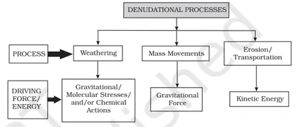
- Denudation – combined processes of weathering, erosion and mass wasting that lower the land surface.
- Relief – vertical difference between highest and lowest points in an area.
- Uplift and Subsidence – vertical movements of the crust that create new relief or lower areas, respectively.
Classification of landforms (by origin): tectonic (mountain ranges, rift valleys), fluvial (valleys, floodplains, terraces), glacial (cirques, U-shaped valleys, moraines), coastal (cliffs, beaches, spits, deltas), aeolian (dunes, yardangs), karst (sinkholes, limestone caves).
Evolution concepts: Landforms evolve by interaction between uplift (creating potential energy and steep slopes) and denudation (reducing relief). Landscapes may approach a dynamic equilibrium where uplift and erosion rates balance. Classic models include the cycle of erosion (youth, maturity, old age/peneplain) and graded rivers (a longitudinal profile tending toward smooth concavity).
Practical significance: Understanding these concepts helps explain soil formation, river behaviour, hazard assessment (landslides, floods), resource distribution and land-use planning.
- Himalayas (fold mountains formed by plate collision; ongoing uplift and high rates of erosion produce steep relief and deep valleys like the Kali Gandaki).
- Indo-Gangetic Plain (extensive depositional plain formed by sediments from Himalayan rivers).
- Deccan Plateau (large volcanic basalt plateau showing erosional remnants and lateritic soils).
- Grand Canyon (USA) — deep canyon carved by the Colorado River illustrating long-term river erosion and rock-stratigraphy exposure.
- Sundarbans and Ganges-Brahmaputra Delta — large depositional delta built by fluvial and tidal processes.
- Western Ghats escarpment — tectonic uplift and differential erosion producing a steep western slope and plateau on the east.
- Slope gradient (ratio) = vertical change / horizontal distance = rise / run
- Slope gradient (percent) = (rise / run) × 100
- Slope angle (degrees) = arctan(rise / run)
- Relief = Elevation(max) − Elevation(min)
- Stream discharge Q = A × v (A = cross-sectional area, v = mean velocity)
- Mean uplift or subsidence rate = vertical displacement ÷ time
Factors Controlling Landform Development
Overview: Landforms develop by the interplay of processes (denudation, transport, deposition) acting on Earth's surface and the intrinsic properties of the crust. The rate, style and final shape of landforms are controlled by several interacting factors: lithology and structure, tectonics (relief/uplift), climate, base level and sea level, time, drainage and slope, biotic cover, and human activity.
Major controlling factors
- Rock type and structure (Lithology): Hard, jointed, or folded rocks resist erosion and form high relief (eg. granite tors, escarpments), whereas soft or fractured rocks are easily worn down. Bedding, joints, faults and foliation guide erosion by creating planes of weakness that control the shape and orientation of valleys, cliffs and cuesta features.
- Tectonics and uplift (Endogenic processes): Uplift increases slope gradients and potential energy available to rivers and glaciers, enhancing incision and relief. Active uplift zones (Himalayas) produce steep, youthful topography; tectonic quiescence leads to peneplains through long-term erosion.
- Climate: Climate determines the dominant denudational processes. Wet, warm climates favor chemical weathering and deep regolith formation; cold climates produce physical weathering (freeze-thaw) and glacial scouring; arid climates favor wind erosion and mass wasting. Rainfall intensity controls runoff and fluvial erosion rates.
- Base level and sea level: Local base level (usually sea level) limits the maximum downcutting of rivers. A fall in base level causes renewed river incision and stream rejuvenation; a rise causes aggradation and delta/coastal landform development.
- Time: Landform evolution is time-dependent. Given sufficient time, even resistant rocks are worn down; short-lived disturbances produce transient forms. Long-term balance between uplift and erosion (dynamic equilibrium) determines whether relief is maintained or reduced.
- Drainage characteristics and gradient: Drainage density, network pattern, discharge and slope control how efficiently water removes material. High drainage density enhances surface runoff and incision; low drainage density implies infiltration and gentler denudation.
- Vegetation and soil cover: Vegetation stabilizes slopes, reduces runoff and protects against erosion. Lack of vegetation (deforestation, deserts) accelerates gullying and slope failure.
- Human activity: Land use change, mining, damming and deforestation can rapidly alter erosion, deposition and slope stability, accelerating landform change compared with natural rates.
- Isostasy: Long-term erosion lowers the crust; isostatic rebound (uplift) can maintain relief by compensating for material removed, influencing long-term landscape form.
Interactions and outcomes: These factors rarely act alone. For example, in a tectonically uplifted region with steep slopes and heavy monsoon rainfall, rivers cut deeply into bedrock producing V-shaped valleys and gorges. In contrast, a stable tectonic plate covered by homogeneous sedimentary rocks under warm humid climate will develop rounded hills and thick soil mantles. The balance between uplift (input of potential energy) and erosion (removal) determines whether landscapes are youthful, mature or old (peneplain).
Practical implications: Understanding controlling factors helps in hazard assessment (landslides), river basin management, coastal planning and conservation (preventing accelerated erosion by vegetation loss or improper land use).
- Himalayas: Active continental collision and rapid uplift produce steep relief, deep river gorges and abundant mass wasting due to tectonics and heavy monsoon climate.
- Deccan Plateau, India: Large extent of hard basalt (trap) rock creates a broad plateau with step-like escarpments where flows have been differentially eroded.
- Grand Canyon, USA: Colorado River incision into uplifted plateau illustrates how uplift + river power cut deep canyons over geologic time.
- Sundarbans (India-Bangladesh): Low-lying deltaic landforms controlled by sea level, sediment supply, tides and mangrove vegetation stabilizing the delta.
- Norwegian fjords: Glacial erosion into uplifted coastal terrain during cold climates created deep, steep-sided inundated valleys (fjords).
- Coastal cliffs like the White Cliffs of Dover: Contrast between resistant chalk beds and weaker strata, plus marine wave action and changing sea level control cliff retreat.
- Drainage density: Dd = ΣL / A, where ΣL = total length of streams and A = drainage basin area. Higher Dd indicates more efficient surface drainage and often greater erosion potential.
- Unit stream power: ω = ρ g q S, where ω = unit stream power (W m^-2), ρ = density of water (kg m^-3), g = gravity (m s^-2), q = discharge per unit width (m^2 s^-1), S = channel slope. Stream power estimates a river's capacity to do work (erode/transport).
- Shear stress on bed (stream power-related): τ = ρ g R S, where τ = shear stress (Pa), R = hydraulic radius (m), S = slope. Larger τ promotes bed erosion and sediment transport.
- Hack's law (empirical relation for rivers): L = C A^h, where L = length of main stream, A = basin area, C and h (≈0.5–0.7) are empirical constants. Useful to relate drainage network geometry to erosion potential.
- Equilibrium between uplift and erosion (conceptual): U = E, where U = uplift rate, E = erosion rate. If U > E, relief increases; if U < E, relief decreases over time.
Endogenic (Internal) Processes
Definition: Endogenic (internal) processes are the earth-shaping mechanisms driven by heat and energy from Earth's interior. They build, deform and elevate the crust, producing structures such as mountains, rift valleys, faults, folds, volcanoes and earthquake zones.
Energy source and basic mechanism: Heat from radioactive decay and residual heat from Earth’s formation drives convection in the mantle. Mantle convection, together with forces such as slab pull and ridge push, moves lithospheric plates. Movement and interaction of plates produce most endogenic landforms and phenomena.
Major types of endogenic processes
- Plate tectonics: Divergent boundaries (sea-floor spreading), convergent boundaries (subduction, collision) and transform boundaries (lateral sliding) — each produces characteristic landforms.
- Volcanism: Magma generation, ascent and eruption form volcanoes (stratovolcanoes, shield volcanoes), lava plateaus and intrusive bodies (plutons, batholiths).
- Earthquakes: Sudden release of elastic strain energy on faults caused by plate motion; produce ground shaking and crustal displacement.
- Deformation — folding and faulting: Compression creates folds and thrusts; tension produces normal faults and rift basins; shear causes strike-slip faults.
- Orogeny (mountain building): Long-term process from plate collision and crustal shortening, uplift and metamorphism (e.g., continental collision forming fold-and-thrust belts).
- Isostasy and crustal adjustment: Vertical motions due to buoyant equilibrium of crust on the mantle — uplift after erosion or ice melting, subsidence from loading.
Timescales and expressions
- Slow/gradual: Uplift, warping, thermal subsidence, mountain-building over millions of years.
- Sudden: Earthquakes and volcanic eruptions that occur in seconds to years but reflect long-term stress accumulation.
Effects on landscapes and human society
- Creates elevation and relief (mountains, plateaus), new land (lava flows, island arcs) and depressions (rift valleys, basins).
- Hazards: earthquakes, volcanic eruptions, tsunamis, ground deformation; but also fertile soils from volcanic ash and mineral deposits.
Simple conceptual diagrams to imagine: cross-section of convergent, divergent and transform boundaries; vertical section through a volcanic arc and subducting slab; block diagram of fold-and-thrust belt; isostatic root beneath a mountain.
- Himalayas — continental collision (India colliding with Eurasia) produced major mountain building by folding, thrusting and uplift.
- Andes — oceanic-continental subduction producing a volcanic mountain chain and regional uplift.
- Mid-Atlantic Ridge — divergent plate boundary with sea-floor spreading and new oceanic crust.
- San Andreas Fault (California) — transform (strike-slip) fault causing frequent earthquakes.
- Ring of Fire (Pacific) — chain of convergent boundaries and volcanoes around the Pacific plate, many active volcanoes and earthquakes.
- Deccan Traps (India) — large flood basalt province from massive volcanic eruptions (trap volcanism).
- Stress (σ) = Force (F) / Area (A). Useful to relate tectonic forces to rock failure.
- Strain (ε) = Change in length (ΔL) / Original length (L). Measures deformation during folding/faulting.
- Seismic moment (M0) = μ × A × D, where μ is rigidity (Pa), A is fault rupture area (m²), and D is average slip (m).
- Moment magnitude (Mw) ≈ (2/3) × (log10 M0 − 9.1). Converts seismic moment to the commonly used magnitude scale.
- Gutenberg–Richter relation: log10 N = a − bM, where N is number of earthquakes ≥ magnitude M; a and b are empirical constants.
Volcanic Processes and Volcanic Landforms
Definition and overview
Volcanic processes are the physical and chemical actions that produce magma, allow its ascent, and cause surface eruptions. Volcanic landforms are the surface features created by erupted material (lava, ash, pyroclasts) and by intrusion of magma into host rocks (dikes, sills, volcanic necks).
Magma generation
Magma forms by partial melting of mantle or crust due to: (1) decompression melting at divergent plate boundaries (mid-ocean ridges, rift zones), (2) addition of volatiles (H2O, CO2) in subduction zones which lowers the melting point of the mantle wedge, and (3) heat anomalies at hotspots (mantle plumes). The source composition (mantle vs crust) and degree of partial melting control magma chemistry.
Properties of magma and their effects
- Composition (silica, SiO2): basaltic (low SiO2 ~45–52%), andesitic (intermediate), rhyolitic (high SiO2 >65%). Higher silica → higher viscosity.
- Temperature: hotter magmas (basaltic) are less viscous and flow easily; cooler magmas (rhyolitic) are viscous and trap gases.
- Volatile content (H2O, CO2, SO2): more gas → more explosive potential if gas cannot escape.
- Viscosity and gas content together determine eruption style: effusive (lava flows) versus explosive (pyroclastic eruptions).
Eruption mechanisms and products
When buoyant magma rises, gas expansion and pressure changes control whether an eruption is gentle or violent. Major products:
- Lava flows — molten rock that moves downslope (common in basaltic eruptions).
- Pyroclastic materials — ash, lapilli, volcanic bombs produced during explosive eruptions.
- Tephra and ash fall — fine particles that travel far and affect climate and health.
- Pyroclastic flows (nuee ardente) — fast, hot mixtures of gas and fragments (very deadly).
- Lahars — volcanic mudflows formed when ash mixes with water (rain, melted glaciers).
- Intrusive features — dikes, sills, laccoliths and volcanic necks formed when magma solidifies within crustal cracks.
Volcanic landforms and how they form
- Shield volcanoes — broad, gently sloping cones built by low-viscosity basaltic lava (e.g., Mauna Loa, Hawaii).
- Composite/stratovolcanoes — steep, conical volcanoes made of alternating lava flows and pyroclastic layers; formed at subduction zones (e.g., Mount Fuji, Mount St. Helens, Mt. Vesuvius).
- Cinder (scoria) cones — small, steep cones formed from accumulation of volcanic fragments around a vent (e.g., Parícutin, Mexico).
- Lava plateaus/flood basalts — extensive flat-lying sheets produced by repeated fissure eruptions of low-viscosity basalt (e.g., Deccan Traps, Columbia River basalts).
- Calderas — large, basin-like depressions formed by collapse following massive eruption and magma chamber evacuation (e.g., Yellowstone, Santorini).
- Volcanic domes — steep-sided mounds of viscous lava (andesitic to rhyolitic) extruded slowly (e.g., the lava dome in Mount St. Helens after 1980).
- Volcanic necks (pipes) — resistant cores left after surrounding rock is eroded (e.g., Shiprock, USA).
- Fissure eruptions and rift volcanoes — long cracks erupting lava, often forming sheet flows and plateaus.
Plate tectonic settings and typical volcano types
- Divergent boundaries (mid-ocean ridges, continental rifts): basaltic magmatism, fissure eruptions, shield volcanoes and new oceanic crust.
- Convergent/subduction zones: volatile-rich, intermediate to felsic magmas → explosive stratovolcanoes and calc-alkaline volcanism.
- Hotspots: intraplate volcanism producing shield volcanoes and island chains (e.g., Hawaiian–Emperor seamount chain).
Hazards and benefits
- Hazards: lava flows, pyroclastic flows, ash fall, lahars, volcanic gases, tsunamis (from flank collapse or submarine eruptions).
- Benefits: fertile soils, geothermal energy, mineral deposits, new land formation and tourism.
Summary
Volcanic processes tie closely to magma generation, composition and tectonic setting. These factors determine eruption style and the variety of landforms—from gentle shield volcanoes to explosive stratovolcanoes, calderas and extensive lava plateaus.
- Mauna Loa and Kilauea (Hawaii) — classic shield volcanoes, basaltic effusive eruptions and lava flows.
- Mount St. Helens (USA) — stratovolcano with explosive 1980 eruption, pyroclastic flows and post-eruption lava dome.
- Mount Fuji (Japan) and Mount Vesuvius (Italy) — stratovolcanoes formed at subduction zones.
- Parícutin (Mexico) — textbook cinder cone that grew from a cornfield in 1943.
- Deccan Traps (India) — flood basalt province formed by fissure eruptions, producing extensive lava plateaus.
- Yellowstone (USA) — supervolcano caldera formed by very large explosive eruptions associated with a hotspot.
- Volume of erupted material (approx.) = Area of deposit × Average thickness. (V = A × t) — useful to estimate erupted volume from mapped deposits.
- Mass of erupted material = Density × Volume. (m = ρ × V) — converts volume to mass when density (ρ) is known.
- Slope angle of a conical volcano: θ = arctan(height / base radius). — gives average flank angle from geometry.
- Recurrence interval (mean) = Total time span / Number of eruptions. — simple estimate of eruption frequency.
- VEI (Volcanic Explosivity Index) is a logarithmic scale (qualitative): each increase in VEI ≈ 10× increase in erupted volume; used to compare eruption magnitudes.
Exogenic (External) Processes
Definition: Exogenic (external) processes are surface processes powered mainly by solar energy, gravity and the atmosphere that break down, transport and deposit rock and soil material. They operate on Earth’s surface to wear down relief produced by endogenic forces and produce characteristic landforms.
Main categories (agents):
- Fluvial (river) processes: weathering, erosion, transportation and deposition by running water. Produce V‑shaped valleys, interfluves, floodplains, meanders, oxbow lakes, alluvial fans and deltas.
- Glacial processes: erosion (plucking, abrasion), transport and deposition by ice. Produce U‑shaped valleys, cirques, arêtes, horns, moraines and drumlins.
- Marine (coastal) processes: wave action, tides and currents. Form cliffs, wave‑cut platforms, bays, headlands, beaches, spits and barrier islands.
- Aeolian (wind) processes: erosion (deflation, abrasion), transport and deposition of dust and sand. Produce dunes, loess deposits, ventifacts.
- Mass wasting (slope processes): downslope movement under gravity — rock fall, landslide, slump, creep.
- Chemical and biological weathering: disintegration and decomposition of rocks in situ, facilitating subsequent removal by other agents.
Key controls: climate (rainfall, temperature, wind), relief/slope, rock type and structure, vegetation cover, drainage pattern, base level (sea level) and time.
Process sequence: Weathering weakens rock → erosion detaches particles → transportation moves them (by water, ice, wind) → deposition occurs where agent loses competence/capacity → resulting landforms evolve.
Human relevance: Exogenic processes determine soil formation, river courses, coastal stability and hazards (floods, landslides, coastal erosion). Land use, deforestation and engineering change rates and patterns of these processes.
- Grand Canyon (USA) — deep canyon carved by the Colorado River (fluvial erosion over millions of years).
- Himalayan U‑shaped valleys and moraines — products of glacial erosion and deposition in high mountains.
- Ganga–Brahmaputra Delta (India/Bangladesh) — extensive alluvial deposition forming a large fan-shaped delta.
- Konkan and Malabar coasts (India) — wave action producing cliffs, beaches and backshore features.
- Thar Desert dunes (Rajasthan) — aeolian transport and deposition forming barchan and transverse dunes.
- Laterite formation in Western Ghats — intense chemical weathering and leaching producing lateritic profiles.
- Discharge: Q = A × v (Q = discharge in m³/s, A = cross‑sectional area in m², v = mean velocity in m/s).
- Manning's equation (open channel flow): v = (1/n) × R^(2/3) × S^(1/2) (v = velocity, n = Manning's roughness, R = hydraulic radius, S = channel slope).
- Stream power: Ω = ρ g Q S (Ω = power per unit length, ρ = water density, g = gravity, Q = discharge, S = slope).
- Shear stress on bed: τ = ρ g R S (τ must exceed critical shear stress to move particles).
- Sediment transport (concept): Total load = bed load + suspended load + dissolved load (no single simple universal formula; transport rises strongly with Q and τ).
- Factor of Safety for slopes: FS = (resisting forces) / (driving forces). If FS < 1, slope failure likely.
Agents of Denudation — Overview
Definition: Denudation is the sum of processes that wear away the Earth's surface leading to reduction of relief and lowering of landforms. It includes weathering (in‑situ disintegration and decomposition), mass wasting (downslope movement under gravity), erosion (removal by an agent), transportation and eventual deposition of material.
Main components:
- Weathering: Physical (mechanical), chemical and biological breakdown of rock at or near the surface. Produces regolith and soil which are then available for removal.
- Mass wasting (slope processes): Soil creep, slump, rockfall, landslides—movement of rock/soil down slopes under gravity without a transporting medium.
- Erosion, transport and deposition: Material removed and moved by agents—running water, glaciers, waves & currents, wind and groundwater—and finally deposited when carrying power falls.
Agents of denudation (overview of processes & typical landforms):
- Running water (rivers, streams, rain runoff): Most important agent globally. Processes: hydraulic action, abrasion, corrosion, solution, attrition. Landforms: V‑shaped valleys, gorges, waterfalls, meanders, oxbow lakes, floodplains, alluvial fans and deltas.
- Glaciers (ice): Ice erodes by plucking and abrasion and transports large loads. Landforms: U‑shaped valleys, cirques, aretes, horns, hanging valleys, fjords, moraines, drumlins.
- Wind (aeolian processes): Effective in arid/semi‑arid regions. Processes: deflation and abrasion. Landforms: dunes, loess deposits, yardangs, deflation hollows.
- Waves and coastal currents: Coastal erosion (cliff retreat, wave‑cut platforms), transportation (longshore drift) and deposition (beaches, spits, bars, tombolos).
- Groundwater (subsurface denudation): Chemical dissolution (especially limestone) producing karst landforms: caves, sinkholes, underground drainage, solution valleys.
- Biological and human agents: Vegetation and organisms accelerate or retard denudation (root wedging, biochemical weathering). Human activities (deforestation, mining, construction) often accelerate denudation rates dramatically.
Factors controlling denudation rates: climate (temperature & precipitation), lithology and rock structure, slope gradient and relief, vegetation cover, drainage density, base level, and time (maturity of landscape). For example, humid tropical climates favour intense chemical weathering and rapid slope denudation, while cold glacial climates favor mechanical erosion by ice.
Interaction of agents: Agents often work together — weathering provides loose material, gravity moves it downslope, running water, ice, wind or waves transport and sort it, and deposition builds new landforms. Landscape evolution reflects the dominant agent(s) and the controlling factors over time.
Measuring denudation: Denudation rate is commonly expressed as vertical lowering of the land surface (mm/yr) or volume loss per unit area per time. Methods include sediment yield measurements from drainage basins, cosmogenic nuclide dating, and long‑term topographic comparisons.
Significance: Denudation shapes Earth’s surface, controls soil formation and sediment supply to rivers/coasts, affects ecosystem stability and human land use, and interacts with tectonics to determine relief through uplift‑denudation balance.
- Grand Canyon, USA — deep canyon carved primarily by running water (Colorado River) showing river incision and layered rock exposure.
- Himalayan U‑shaped valleys and cirques (e.g., valleys in Kashmir and Ladakh) — classic glacial sculpting.
- Thar Desert, India — dunes and yardangs formed by wind erosion and deposition.
- Sundarbans/Delta of the Ganga–Brahmaputra — deposition by rivers forming extensive alluvial plains and deltas.
- Meghalaya caves and sinkholes — karst features produced by groundwater dissolution of limestone.
- Uttarakhand landslides — accelerated mass wasting triggered by heavy rain, steep slopes, deforestation and human activity.
- Denudation rate (vertical lowering): R = Δh / t (units: mm yr⁻¹ or m yr⁻¹), where Δh = change in elevation and t = time interval.
- Denudation rate (volumetric): R = V / (A · t) (m yr⁻¹), where V = volume removed, A = area of basin, t = time.
- Stream power (river’s ability to do work/erode): Ω = ρ g Q S (W m⁻¹), where ρ = water density, g = gravity, Q = discharge (m³ s⁻¹), S = channel slope.
- Shear stress on bed (important for entrainment): τ = ρ g R S (Pa), where R = hydraulic radius (≈ depth), S = energy slope.
- Basal shear stress for glacier sliding: τ_b = ρ g h sin α, where h = ice thickness and α = surface slope.
- Threshold wind shear velocity (for particle entrainment): u* = sqrt(τ_c / ρ), where τ_c = critical shear stress and ρ = air density.
Fluvial (River) Processes and Landforms
Definition: Fluvial (river) processes are the actions of running water that erode, transport and deposit sediments to produce characteristic landforms. Rivers are the dominant agents of landscape change from mountains to oceans.
Main processes
- Erosion – removal of material by running water. Major types: hydraulic action (water pressure and turbulence), abrasion (sediment rubbing bed/ banks), attrition (particles colliding and breaking), and solution (chemical dissolution of soluble material).
- Transportation – movement of sediment in four modes: traction (rolling/bouncing of large clasts), saltation (hopping of sand/gravel), suspension (fine silt/clay carried within flow), and solution (dissolved load).
- Deposition – settling of sediment when river velocity and carrying capacity drop (at lower slope, reduced discharge, or meeting standing water).
Controls on fluvial activity: gradient/slope, discharge (volume/time), sediment load and size, channel shape and roughness, base level (sea level or lake level), lithology, climate (rainfall regime), vegetation and tectonics.
River profile and stages
- Longitudinal profile: typically a smooth concave-up curve from source (high gradient) to mouth (low gradient). A graded stream has a profile in equilibrium with transport capacity.
- Youthful (upper course): steep gradient, dominant vertical (downcutting) erosion → V-shaped valleys, rapids, waterfalls, interlocking spurs.
- Mature (middle course): reduced gradient, lateral erosion and valley widening → meanders, floodplain development, point bars and cut banks.
- Old (lower course): very low gradient, high deposition → extensive floodplains, levees, deltas and alluvial plains.
Characteristic landforms
- Upper course: V-shaped valleys, interlocking spurs, waterfalls and gorges, potholes.
- Middle course: meandering channels, ox-bow lakes, point bars, cut-banks, natural levees.
- Lower course: braided channels (multiple interlacing channels where load is high and discharge variable), floodplains, backswamps, river terraces (remnant benches of former floodplain), alluvial fans (at mountain front where slope abruptly drops) and deltas at river mouths (various types: arcuate, bird’s-foot, cuspate) .
Rejuvenation and knickpoints: Tectonic uplift or fall of base level increases river’s erosive power, producing features like incised meanders, river terraces and knickpoints/waterfalls.
Significance: Rivers shape landscapes, create fertile soils (alluvium), recharge groundwater, provide water for irrigation, industry and domestic use, offer navigation and hydroelectric potential, but also pose flood hazards.
Class-level summary: Understand the three-step cycle (erosion–transport–deposition), stage-wise landform evolution (upper–middle–lower course), controlling factors, and key landforms (meander sequence, delta types, alluvial fan, terraces). Diagrams (longitudinal profile, meander evolution, cross-sections) are essential to explain processes visually.
- Waterfalls and gorges: Jog Falls (Sharavathi River, Karnataka) and Narmada gorges at Bhedaghat (Madhya Pradesh).
- Interlocking spurs and V-shaped valleys: Upper reaches of Himalayan rivers (e.g., headwaters of the Yamuna, Ganga tributaries).
- Braided rivers: Upper Brahmaputra and Kosi (noted for shifting braided channels and high sediment load).
- Meanders and ox-bow lakes: Meandering reaches of the Ganga and many rivers in the Indo-Gangetic Plain; ox-bow lakes found in Bihar and West Bengal floodplains.
- Alluvial fan: Kosi river fan at the Himalayan piedmont; numerous fans along Himalayan foothills.
- River terraces: Terraces along the Yamuna and Ganga in the Indo-Gangetic plains due to past changes in base level and climate.
- Discharge (Q): Q = A × v, where A = cross-sectional area (m^2) and v = mean velocity (m/s).
- Hydraulic radius (R): R = A / P, where P = wetted perimeter (m).
- Manning’s equation (approximate open-channel flow velocity): v = (1/n) × R^(2/3) × S^(1/2), where n = Manning roughness coefficient, S = slope (m/m).
- Bed shear stress (τb): τb = ρ × g × R × S, where ρ = water density, g = gravity, R = hydraulic radius, S = energy slope.
- Stream power (Ω): Ω = ρ × g × Q × S (rate of energy expenditure by the river per unit time).
- Sinuosity index: Sinuosity = Channel length / Straight-line valley length (values >1.5 indicate a meandering river).
River Rejuvenation and Related Features
Definition: River rejuvenation is the renewed erosional activity of a river when its potential energy increases relative to its base level. This causes the river to cut down into its bed, producing a suite of erosional and depositional landforms.
Causes of rejuvenation:
- Tectonic uplift of the land (raises the river above its previous base level).
- Fall in base level (sea-level fall or local base-level drop such as lake outflow).
- Climatic change (increased precipitation/discharge, or reduced vegetation increasing runoff).
- River capture / stream piracy (one stream intercepts another, increasing discharge and erosion).
Process: When uplift or base-level fall increases the river's gradient (slope) or discharge, stream power rises. The river responds by renewed vertical erosion (incision) to re-establish a new graded profile. This produces knickpoints (breaks in the longitudinal profile) that migrate upstream, leaving old floodplains stranded as terraces. Continued downcutting can produce gorges and entrenched meanders.
Key landforms produced by rejuvenation:
- Knickpoint/knickzone — a sudden change in gradient on the longitudinal profile (e.g., waterfall location). Knickpoints migrate upstream with erosion.
- Waterfalls and rapids — form where resistant beds overlie softer rock or where there is an abrupt base-level change.
- Gorges and canyons — deep, narrow valleys produced by prolonged vertical cutting (e.g., Grand Canyon by the Colorado River).
- Incised or entrenched meanders — meanders that have been cut deeply into bedrock when a meandering floodplain is uplifted or base level falls; can be symmetric (entrenched) or asymmetric (incised).
- River terraces — step-like remnants of former floodplains. Formed by a cycle of lateral planation followed by renewed vertical incision. Paired terraces occur at similar elevations on both sides; unpaired terraces occur at differing elevations.
- Wind gaps and beheaded streams — evidence of river capture. A wind gap is a dry former valley; a beheaded stream is the truncated upstream part of a captured river.
Significance: Rejuvenation explains many inland erosional features and the formation of terraces used for reconstructing past tectonic and climatic events. It is important for floodplain evolution, aquifer recharge, and landscape history.
Observational indicators: prominent knickpoints on longitudinal profiles, stepped terraces along valley sides, steep narrow gorges downstream of knickpoints, incised meander loops, presence of wind gaps or abrupt changes in tributary patterns.
- Grand Canyon (Colorado River, USA) — intense incision due to uplift of the Colorado Plateau producing a deep canyon.
- Niagara Falls (Canada/USA) — a migrating knickpoint/ waterfall and gorge developed after glacial changes in base level.
- Terraces of the Ganga Plain (India) — fluvial terraces related to Himalayan uplift and climatic fluctuations.
- Beheaded/Ghaggar-Hakra system and Sutlej (hypothesized river capture events in northwestern India/Pakistan) — example of stream piracy altering drainage and rejuvenating channels.
- Stream gradient (S) = Vertical fall (Δh) / Horizontal distance (L). Units: m/km or dimensionless (m/m).
- Sinuosity (Si) = Channel length (Lc) / Valley (straight) length (Lv). Si > 1.5 indicates a meandering channel.
- Discharge (Q) = Cross-sectional area (A) × Mean velocity (V). Q = A · V (m³/s).
- Stream power (Ω) = ρ g Q S (power per unit length) — relates discharge and slope to erosive capability (ρ = water density, g = gravity, Q = discharge, S = slope).
- Shear stress (τ) ≈ ρ g R S (R = hydraulic radius) — resisting force that moves sediment; higher τ → more erosion.
- Manning's equation (practical velocity estimate): V = (1/n) · R^(2/3) · S^(1/2), where n is Manning's roughness coefficient.
Glacial Processes and Landforms
Overview
Glaciers are persistent bodies of dense ice that form where snowfall exceeds melt over many years. Glacial processes shape landscapes by erosion, transport and deposition of rock and sediment. Two broad glacier classes are alpine (valley) glaciers and continental (ice sheets/caps). The balance between accumulation and ablation controls glacier advance or retreat and thus landscape evolution.
Formation and Motion
- Formation: Snow → firn → glacial ice by compaction and recrystallization.
- Flow mechanisms: Internal deformation (creep of ice crystals) and basal sliding (ice slides over bed because of meltwater or regelation).
- Flow components: Surface velocity is generally faster than basal; flow is fastest at centerline of valley and decreases toward margins.
Erosional Processes
- Plucking (quarrying): Meltwater penetrates bedrock fractures, freezes and pries out blocks as ice moves.
- Abrasion: Rock fragments embedded in ice grind the bedrock producing fine rock flour and striations; produces smooth lee-side forms.
- Freeze–thaw / frost action: Repeated freezing widens fractures aiding plucking.
- Pressure melting & regelation: Pressure-induced melting on the stoss side of obstacles and refreezing on the lee side facilitate movement around obstacles.
Transport
- Material carried as supraglacial (on top), englacial (within), and subglacial (beneath) load.
- Transport modes include sediment entrainment, traction and suspended load.
Depositional Processes and Landforms
- Moraines: Lateral, medial, terminal (end), ground and recessional moraines—accumulations of till marking former glacier margins.
- Drumlins: Streamlined, elongate hills of till oriented in direction of ice flow.
- Eskers: Sinuous ridges of sand and gravel deposited by subglacial meltwater tunnels.
- Kames and kame terraces: Irregular mounds/terraces of sorted sand and gravel from supraglacial/englacial deposition.
- Kettles: Depressions formed where stranded ice blocks melted, leaving lakes or hollows.
- Outwash plains (sandurs): Broad, braided-stream deposits of meltwater beyond glacier margins.
- Loess: Wind-blown silt derived from glacial outwash; forms fertile mantles downwind.
Classic Glacial Erosional Landforms (Alpine)
- Cirque (cwm): Bowl-shaped hollow at the head of a glacier.
- Arête: Sharp ridge between adjacent cirques or valleys.
- Horn: Pyramidal peak formed by headward erosion of several cirques (e.g., Matterhorn).
- U-shaped valley (glacial trough): Wide, flat-floored valley with steep sides replacing a V-shaped river valley (e.g., Yosemite Valley).
- Hanging valley: Tributary glacial valley left 'hanging' above the main trough; often site of waterfalls.
- Roche moutonnée: Asymmetric bedrock knob polished on stoss side and plucked on lee side.
- Fjords: Deep, drowned glacial troughs now filled by sea (e.g., Norway, New Zealand Fiordland).
Continental Ice Sheet Features
- Large-scale scouring and deposition: extensive till sheets, drumlin fields, broad outwash plains and abundant kettle lakes.
- Long-range dust transport from outwash produces loess regions (e.g., Chinese Loess Plateau, U.S. Midwest).
Glacier Budget and Climate Link
- Mass balance: Net accumulation (snowfall) minus ablation (melting, sublimation) controls glacier advance/retreat.
- Equilibrium Line Altitude (ELA): Altitude where annual accumulation equals ablation—sensitive indicator of climate change.
Timescales: Glacial erosion and deposition operate over decades to millions of years depending on climate, ice thickness and substrate. Many current landforms reflect past (Pleistocene) ice advances as well as present glaciers.
- U-shaped valley — Yosemite Valley, California, USA
- Cirques and horns — the Matterhorn and surrounding cirques, Swiss-Italian Alps
- Fjords — Sognefjord (Norway), Milford Sound (New Zealand)
- Terminal moraine — Reusch Glacier moraines in Svalbard and many glacier forelands worldwide
- Drumlin fields — County Mayo and other parts of Ireland; drumlin fields across the U.S. Great Lakes region
- Eskers — long ridges in Saskatchewan and parts of Ireland
- Basal shear stress: τ_b = ρ g H sin(α) (ρ = ice density ≈ 917 kg/m^3, g = 9.81 m/s^2, H = ice thickness, α = slope angle)
- Glen's flow law (constitutive law for ice creep): ε̇ = A τ^n (ε̇ = strain rate, τ = shear stress, A = temperature-dependent rate factor, n ≈ 3)
- Volume flux (per unit width): q = H · ū (H = ice thickness, ū = depth-averaged velocity)
- Continuity / mass conservation (1D): ∂H/∂t = ḃ - ∂(H ū)/∂x (ḃ = net mass balance rate; x = downslope coordinate)
- Net mass balance (yearly): B = Accumulation - Ablation (B > 0 → advance/potential growth; B < 0 → retreat)
- Equilibrium Line: altitude where annual B = 0 (no single numeric formula; determined from field/remote-sensing data)
Coastal Processes and Landforms
Overview
Coastal processes are the actions of waves, tides and currents that shape the shoreline by eroding, transporting and depositing sediments. The interaction of these processes with rock type, sea-level change and human activity produces characteristic coastal landforms.
Primary coastal agents
- Waves — generated by wind blowing over water. Key features: crest, trough, wavelength (L), period (T), amplitude (A). Waves approach the shore and change form (shoaling and breaking), producing erosion or deposition depending on their energy:
- Constructive waves: low, long wavelength, strong swash and weak backwash → build beaches (deposit).
- Destructive waves: high, short wavelength, strong backwash → erode shore (remove material).
- Tides — periodic rise and fall of sea level due to gravitational pull of moon and sun. Tides control the vertical extent of wave action (intertidal zone) and influence estuary and delta dynamics.
- Coastal currents — longshore currents (parallel to shore) and rip currents (seaward), driven by oblique wave approach and tides. They transport sediments along and away from the coast.
Processes
- Erosion — hydraulic action, abrasion (sand/pebble grinding), attrition, solution (chemical). Produces cliffs, wave-cut platforms, caves, arches and stacks.
- Transportation — traction, saltation, suspension and solution move sediment. Longshore drift (littoral drift) transports sediment along the coast when waves hit at an angle.
- Deposition — occurs where wave energy falls (sheltered bays, behind headlands, where longshore transport slows). Produces beaches, spits, bars, tombolos, barrier islands and lagoons.
Typical coastal landforms
- Erosional landforms: cliffs, wave-cut platforms (bench at cliff base), sea caves → arches → stacks → stumps (sequential collapse as erosion proceeds).
- Depositional landforms: beaches (sand/gravel accumulations with berms), spits (long narrow ridges attached at one end), bars (ridge across a bay), tombolos (ridge connecting island to mainland), barrier islands, dunes (wind-blown sand piles behind beaches), lagoons (water bodies behind barriers).
- Coastal inlets and wetlands: estuaries (drowned river mouths with tidal influence) and deltas (river sediment builds out into the sea). Delta types include arcuate (fan-shaped, e.g., Ganges–Brahmaputra), bird’s-foot (prograding distributaries, e.g., Mississippi), and cuspate (pointed projection).
Controls and variations
Rock type and structure determine resistance to erosion (hard rock → cliffs and headlands; soft rock → bays). Shoreline orientation relative to prevailing wind and waves controls sediment transport direction. Sea-level change (eustatic or isostatic) and human activities (coastal engineering, sand mining) modify natural evolution.
Importance
Coasts support ecosystems (mangroves, salt marshes), human settlements, ports and tourism. Understanding coastal processes is essential for hazard mitigation (erosion, flooding) and sustainable management.
Sequence example (arch formation): Wave attack on headland → formation of a cave → enlargement to an arch → collapse of arch leaving an isolated stack → further erosion to a stump.
- Ganges–Brahmaputra delta (Arcuate delta) — largest delta in the world; extensive depositional plain (Sundarbans mangrove forests).
- Mississippi Delta (Bird’s-foot delta) — distributary-dominated protruding form due to strong river deposition and weak wave reworking.
- Chilika Lake (Odisha, India) — lagoon separated from the sea by a sandbar; shows coastal deposition and lagoon dynamics.
- Tidal estuary — Hooghly estuary (West Bengal, India) shows strong tidal influence and navigation issues.
- Beach and dune system — Marina Beach (Chennai) — long sandy beach with dune/backshore features (subject to erosion and seasonal change).
- Wave-cut platform and cliffs — Cliffs of Moher (Ireland) and other rocky coasts illustrate erosional features; smaller-scale wave-cut platforms occur along rocky Indian coasts.
- Wave celerity (speed): C = L / T (where C = wave speed, L = wavelength, T = period)
- Deep-water wavelength relation: L = g T^2 / (2π) (g = acceleration due to gravity ≈ 9.81 m/s²)
- Wave energy per unit horizontal area: E = (1/8) ρ g H² (ρ = water density ≈ 1025 kg/m³, H = wave height)
- Approximate longshore sediment transport (CERC formula, conceptual): Q = K Hb² sin(2αb) (Q = transport rate, K = empirical constant, Hb = breaker height, αb = wave angle at breaking)
Aeolian (Wind) Processes and Landforms
Definition and scope
Aeolian (wind) processes are the erosion, transportation and deposition of sediments by wind. They are most effective in arid and semi‑arid regions where vegetation is sparse, soil is dry and particles are loose. Aeolian action shapes characteristic landforms in deserts, coastal dunes and loess provinces.
Main processes
- Erosion
- Deflation – removal of loose fine particles (silt and sand) by wind, producing deflation hollows, blowouts and desert pavements (lag deposits of coarse pebbles).
- Abrasion – mechanical wearing of rock surfaces by sand grains carried in the wind; produces polished surfaces, grooves and streamlined forms.
- Attrition – particles collide and break into smaller, rounded grains during transport.
- Transportation
- Traction (surface creep) – very coarse grains roll or slide along the ground.
- Saltation – sand-sized grains are lifted briefly and hop in ballistic trajectories; principal mode for sand transport.
- Suspension – fine silt and clay remain aloft for long distances (dust storms).
- Deposition – occurs where wind velocity falls below the threshold needed to carry particles; results in dunes, sand sheets and loess deposits.
Factors controlling aeolian activity
- Wind velocity and variability (gusts versus steady winds).
- Vegetation cover and surface moisture (both reduce erosion).
- Particle size and density (very fine particles suspend; medium sand saltates; coarse particles move by traction).
- Topography and obstacles (cause wind deceleration and deposition).
Aeolian landforms
- Erosional landforms: deflation hollows (blowouts, pans), desert pavements (regs), yardangs (streamlined rock ridges carved by abrasion), ventifacts (wind‑abraded rocks with faceted surfaces), pedestal or mushroom rocks.
- Depositional landforms:
- Dunes – accumulations of sand shaped by wind regime and sand supply. Important dune types:
- Barchan: crescentic horns pointing downwind; form with limited sand and a single dominant wind direction.
- Transverse: long ridges perpendicular to prevailing wind; abundant sand, unidirectional wind.
- Longitudinal (seif): long ridges parallel to resultant wind direction; formed where winds from two directions produce a resultant flow and moderate sand supply.
- Parabolic: U‑shaped with horns pointing upwind; often stabilized at margins by vegetation (common in coastal zones).
- Star: radiating arms from a central peak; form under multidirectional wind regimes and abundant sand.
- Sand sheets – broad flat areas of sandy surface with sparse ripple forms.
- Loess – widespread, thick deposits of silt and fine sand blown and deposited over large areas; highly fertile but susceptible to erosion.
- Ergs – extensive sand seas or dune fields (e.g., Sahara erg).
- Dunes – accumulations of sand shaped by wind regime and sand supply. Important dune types:
Processes in profile (how dunes form)
Sand is moved up the gentle windward slope by saltation. When grains reach the crest, they fall down the steeper slip face (angle of repose ~30–34°) and accumulate. Over time the dune migrates downwind as sand is eroded from the stoss (windward) side and deposited on the lee side.
Environmental and human significance
Aeolian processes redistribute fertile loess soils (e.g., China), cause dust storms that affect air quality and climate, and can damage agriculture, infrastructure and settlements by sand encroachment. Management includes dune stabilization (planting vegetation, erecting fences), windbreaks, and soil conservation techniques.
Time scale
Aeolian landforms can form relatively quickly (years to centuries for dunes) or slowly (loess accumulation over thousands of years). Changes depend on climatic shifts and human activity.
Summary: Wind shapes landscapes by removing, carrying and depositing particles. Resulting landforms (yardangs, dunes, loess) reflect wind strength, directionality, sand supply and surface conditions.
- Thar Desert (India): extensive dune fields (barchan and transverse dunes) and sand sheets.
- Sahara Desert (North Africa): vast ergs (sand seas), yardangs and dust storms.
- Loess Plateau (China): thick loess deposits formed by long‑distance wind transport of silt; highly fertile soils.
- Dust Bowl (Great Plains, USA, 1930s): example of wind erosion exacerbated by poor land management causing large‑scale soil loss and dust storms.
- Rub' al Khali (Empty Quarter, Arabian Peninsula) and Simpson Desert (Australia): large dune deserts with migrating dunes.
- Yardangs in the Lut Desert (Iran) and ventifacts in high desert plateaus (e.g., parts of Ladakh and the western USA).
- Wind (friction) velocity: u* = sqrt(τ / ρ) where τ = shear stress (N/m²) and ρ = air density (kg/m³).
- Logarithmic wind profile: u(z) = (u* / κ) · ln(z / z0) where u(z) is wind speed at height z, κ (von Kármán constant) ≈ 0.4, and z0 is surface roughness length.
- Threshold (critical) friction velocity for particle motion (approximate): u*t ≈ A · sqrt(((ρp - ρ) · g · d) / ρ) where ρp = particle density, ρ = air density, g = gravity, d = particle diameter, and A is an empirical constant (~0.1–0.2 depending on conditions).
- Bagnold's empirical sand transport relation (volume transport per unit width, simplified): q ∝ (ρ / g) · u*³ (transport rate increases roughly with cube of friction velocity).
- Settling (fall) velocity for very small particles (Stokes' law, laminar regime): ws = ((ρp - ρ) · g · d²) / (18 · μ) where μ is dynamic viscosity of air; used to estimate suspension versus deposition.
Karst and Groundwater-Related Landforms
What is karst? Karst refers to landscapes and underground drainage systems formed mainly by the chemical dissolution of soluble rocks (especially carbonate rocks such as limestone and dolomite, and less commonly gypsum). Water charged with dissolved carbon dioxide (carbonic acid) percolates through joints, bedding planes and fractures, dissolving rock and creating characteristic surface and subsurface landforms.
Key process (chemical dissolution)
- Rainwater absorbs CO2 from the atmosphere and soil producing weak carbonic acid: CO2 + H2O → H2CO3.
- Carbonic acid reacts with calcite (CaCO3) in limestone: H2CO3 + CaCO3 → Ca2+ + 2 HCO3–. Dissolved calcium and bicarbonate are carried away in solution.
- Where water degasses (loses CO2) or becomes oversaturated, calcite can re-precipitate forming speleothems: Ca2+ + 2 HCO3– → CaCO3 + H2O + CO2.
Typical karst and groundwater-related landforms
- Sinkholes / dolines: closed depressions formed by subsidence or collapse over dissolved cavities.
- Swallow holes / sink points and disappearing streams: surface streams that sink into the ground via openings.
- Blind valleys and dry valleys: valleys that end abruptly where water sinks underground.
- Poljes: large flat-floored depressions with fertile soils and seasonal flooding (often bounded by steep walls).
- Lapiés / limestone pavements: grooved and fluted rock surfaces created by solution along joints.
- Karst towers / mogotes: residual steep-sided hills in tropical karst (tower karst), e.g., Guilin.
- Caves and cave passages: subterranean conduits formed by dissolution and enlargement of fractures; include chambers and passages of varying size.
- Speleothems: stalactites (hang from ceiling), stalagmites (rise from floor), columns, flowstones, rimstone pools formed by precipitation of calcite.
- Springs and resurgences: places where groundwater returns to the surface; can be perennial or intermittent depending on aquifer characteristics.
Karst aquifers and groundwater flow
- Karst aquifers commonly show dual flow: slow diffuse flow through the rock matrix and rapid conduit flow through enlarged fractures and caves. This makes karst aquifers highly heterogeneous and capable of rapid groundwater transfer.
- Water table, perched water, confined vs. unconfined conditions, and seasonal recharge control spring behavior. Recharge is strongly influenced by vegetation/soil cover, rainfall intensity and fracture connectivity.
Factors controlling karst development
- Rock type and purity (pure, thick carbonate beds dissolve more readily).
- Climate—temperature and rainfall; humid climates and warm conditions with high soil CO2 accelerate dissolution (tropical karst produces dramatic tower landscapes).
- Structure—joints, faults, bedding planes control drainage patterns and location of caves.
- Vegetation and soil—increase soil CO2 and infiltration, enhancing chemical weathering.
- Time—karst features develop over long periods, though some collapse events (sinkholes) can be sudden.
Environmental and human significance: Karst aquifers supply important groundwater resources (e.g., springs used for drinking water). They are also vulnerable to contamination because pollutants can travel rapidly through conduits. Sinkhole hazards affect infrastructure. Caves are important for biodiversity and tourism.
- Mammoth Cave, Kentucky, USA — the world’s longest known cave system in limestone.
- Carlsbad Caverns, New Mexico, USA — extensive limestone caves and speleothems.
- Yucatán Peninsula cenotes, Mexico — sinkholes connected to an extensive coastal karst aquifer.
- Guilin and Yangshuo, Guangxi, China — classic tropical tower karst landscape.
- Nullarbor Plain, Australia — extensive exposed karst with sinkholes and caves.
- Siju Cave and Krem Liat Prah (longest cave), Meghalaya, India — prominent Indian karst caves.
- CO2 + H2O → H2CO3 (formation of carbonic acid)
- H2CO3 + CaCO3 → Ca2+ + 2 HCO3– (dissolution of calcite / limestone)
- Ca2+ + 2 HCO3– → CaCO3 + H2O + CO2 (re-precipitation / speleothem formation)
- Darcy's law (groundwater flow, bulk form): Q = -K A (dh/dl) where Q = discharge, K = hydraulic conductivity, A = cross-sectional area, dh/dl = hydraulic gradient
- Specific discharge (Darcy velocity): q = -K (dh/dl) (used to estimate average flow velocity in porous media)
Structural Landforms and Resultant Features
Definition: Structural landforms are landforms produced primarily by movements or deformation of the Earth's crust (folding, faulting, warping, tilting and volcanic activity). Resultant features are the shapes produced directly by these movements or after subsequent erosion and deposition modifies the structure.
Main processes and the landforms they produce
- Folding (compressional forces): Layers of rock bend into waves. Primary structures are anticlines (upward-arching folds) and synclines (downward trough-like folds).
- Faulting (fracturing and displacement): Rocks break and blocks move relative to each other. Types: normal faults (extensional, hanging wall moves down), reverse/thrust faults (compressional, hanging wall moves up), strike-slip faults (lateral movement).
- Warping and bulging: Gentle, large-scale bending of crust producing domes (upward bulges) and basins (downwarps).
- Block faulting: Large blocks bounded by faults move up or down to form horsts (uplifted blocks) and grabens (down-dropped blocks or rift valleys).
- Tilting of strata: Inclined or tilted sedimentary layers lead to differential erosion and produced features like cuestas, hogbacks, mesa–butte sequences and escarpments.
Resultant landforms (with short process note):
- Fold mountains: Long, high mountain belts produced by intense folding and thrusting (e.g., Himalaya, Alps).
- Rift valleys and grabens: Elongated low areas bounded by normal faults (e.g., East African Rift, Rhine Graben).
- Horsts (block mountains): Uplifted blocks flanking grabens (e.g., Black Forest and Vosges beside the Rhine Graben).
- Fault scarps and escarpments: Steep slopes produced by fault movement or by erosion of tilted rocks (e.g., scarps along active faults; Western Ghats form a major escarpment in India).
- Domes and basins: Circular/elliptical upwarps and downwarps; domes bring older rocks to the surface (e.g., Black Hills, USA — a dome exposing Precambrian rocks).
- Cuestas and hogbacks: Formed on gently to steeply dipping strata: cuestas have a gentle dip slope and a steep scarp; hogbacks are steeply tilted equivalents.
- Mesas and buttes: Isolated flat-topped remnants of horizontal strata formed by differential erosion in arid/semi-arid areas (e.g., Monument Valley, Colorado Plateau).
Interaction with erosion: Structural landforms are often modified by weathering, rivers, glaciers and wind. For example, a broad anticline may be carved into a range of ridges and valleys; mesas may be reduced to buttes and then to pinnacles.
How to read structural maps and cross-sections: Look for strike-and-dip symbols and structural contours. Cross-sections show fold amplitude and wavelength; map views show the outcrop pattern (anticline as concentric lines, syncline with reversed pattern).
Practical importance: Structural landforms control drainage patterns, soil distribution, mineral deposits (folds and faults trap hydrocarbons), and earthquake/landslide susceptibility.
- Himalaya (fold mountains formed by collision and thrusting of the Indian plate with Eurasia) — anticlines, synclines, thrust faults.
- East African Rift (active rift valley and grabens formed by continental extension) — volcanoes and steep escarpments.
- Rhine Graben (European rift) with Vosges and Black Forest as flanking horsts.
- Western Ghats, India (prominent escarpment marking the edge of the Deccan Plateau — result of tilting and erosion).
- Colorado Plateau / Monument Valley, USA (mesas, buttes and plateau remnants from differential erosion of horizontal strata).
- Black Hills, USA (a dome exposing older rocks at the centre).
- Relief = Maximum elevation − Minimum elevation (simple measure of vertical difference).
- Slope (gradient) = rise / run (expressed as a decimal).
- Slope percent = (rise / run) × 100.
- Slope angle (θ) = arctan(rise / run) (gives angle in degrees).
- Uplift rate ≈ vertical displacement / time (useful where displacement and age are known).
- Approximate dip angle (when vertical thickness and horizontal extent known): dip θ ≈ arctan(vertical thickness / horizontal extent).
Landform Evolution Models and Theories
Landform evolution models and theories are conceptual and mathematical frameworks used to explain how landscapes develop, change and reach different states through interactions among tectonics, climate, rock properties and surface processes (weathering, mass wasting, fluvial erosion and deposition). These models help geographers and geomorphologists interpret present landforms and predict future changes.
Major classical theories
Davis' Cycle of Erosion (Theory of Geographical Cycle)
- Core idea: Landscapes evolve through an ordered temporal sequence after a tectonic uplift: Youth → Maturity → Old age (peneplain).
- Key features: youth (steep slopes, V-shaped valleys), maturity (well-developed drainage, widened valleys), old age (low relief, near-base level plains).
- Assumptions: single uplift event, constant climate, long time with little tectonic activity, rivers adjust to a stable base level.
- Usefulness: simple, intuitive framework for relative landform dating and teaching.
- Criticisms: unrealistic assumptions (multiple uplifts, variable climate), ignores simultaneous processes and tectonics; many landscapes never reach peneplain.
Penck's Theory (Parallel Slope Retreat)
- Core idea: Uplift and erosion act simultaneously. Slopes retreat parallel to themselves producing characteristic slope profiles.
- Key predictions: slope forms are mainly controlled by rates of uplift and erosion; age is not the only control—rate of uplift matters.
- Strengths: more realistic where uplift continues while erosion proceeds (e.g., mountain belts).
- Differences from Davis: Penck emphasizes concurrent uplift and erosion (no fixed cycle stages) and slope retreat rather than slope decline through time.
King's Graded Profile
- Core idea: A river adjusts its channel profile so that its transport capacity equals the sediment supply — a graded river in equilibrium with its load and discharge.
- Implication: if sediment supply or discharge changes, the river adjusts by aggrading or degrading (forming knickpoints or terraces) until a new graded state is reached.
Hack's Dynamic Equilibrium
- Core idea: Landscapes are in continual adjustment; rivers and slopes respond to changes in tectonics and climate and tend toward a dynamic balance rather than a static end-state.
- Emphasis on measurable relationships (for instance slope-area relationships) and on process-based explanation rather than rigid temporal cycles.
Modern quantitative models and concepts
- Stream-power (fluvial incision) models: River incision and landscape lowering are modeled using relations that involve discharge (or drainage area), channel slope and erodibility. These capture how erosion rate depends on water energy.
- Slope-evolution (diffusive) models: Hillslope lowering by soil creep or small mass movements can be approximated by a diffusion equation where flux is proportional to slope; this smooths topography over time.
- Threshold and stochastic models: Introduce thresholds for transport (e.g., minimum rainfall or shear stress needed to move material) and random events (storms, landslides) producing episodic change.
- Tectonic and climatic forcing: Modern frameworks combine uplift rate, climate-driven runoff/sediment supply and lithology to predict steady-state (balance between uplift and erosion) or transient landscapes (adjusting to changed forcing).
How to use these theories to interpret landscapes
- Look at slope forms, drainage density, valley cross-section, knickpoints, river terraces and regional elevation to infer if uplift is recent/ongoing (youthful, steep relief) or if landscape is older and subdued.
- Identify knickpoints or abrupt profile changes as evidence of transient response to uplift or base level change.
- Combine qualitative models (Davis, Penck) with quantitative indicators (slope-area relationships, erosion rates) for robust interpretations.
Summary comparison: Davis gives a time-sequence, simple and pedagogic but often unrealistic; Penck emphasizes simultaneous uplift and erosion and parallel slope retreat; King focuses on river adjustment to sediment/load balance; Hack and modern models emphasize dynamic balance, measurable process laws and the role of tectonics and climate.
- Davisian-type interpretation: Appalachian Mountains (USA) show subdued relief and rounded summits interpreted as older, more ‘mature’ stages in a relative sense.
- Penck-style landscapes: Active mountain belts such as parts of the Alps and parts of the Himalaya where uplift and erosion act together and slopes often retreat while maintaining their form.
- Graded rivers (King): Low-gradient, meandering rivers on stable cratons and plains such as parts of the Mississippi where long-term balance between sediment supply and transport capacity exists.
- Modern process examples: Rapid knickpoint migration in rivers of uplifted terrain (e.g., knickzones on some Himalayan rivers) demonstrating transient response to uplift; coastal cliffs retreating by slope processes showing diffusive slope evolution.
- Stream power per unit channel length: Ω = ρ g Q S (ρ = water density, g = gravity, Q = discharge, S = channel slope). Often used in simplified proportional form Ω ∝ Q S.
- Stream power (per unit width) / incision (stream-power law): E = K A^m S^n where E = erosion/incision rate, K = erodibility coefficient, A = upstream drainage area (proxy for discharge), S = local slope; m and n are empirical exponents (typical m ~ 0.3–0.8, n ~ 0.8–1.2).
- Hillslope diffusion (linear diffusion model): ∂z/∂t = D ∂^2z/∂x^2 - U where z = elevation, t = time, D = diffusivity (soil creep efficiency), U = uplift rate. Describes smoothing of slopes over time.
- Discharge relation (basic): Q = A_c · V where Q = discharge, A_c = cross-sectional area of flow, V = mean velocity. (Velocity can be estimated by Manning's equation.)
- Manning's formula (empirical velocity): V = (1/n) R^(2/3) S^(1/2) where V = mean velocity, n = Manning roughness, R = hydraulic radius, S = energy slope (≈ channel slope).
Soil, Regolith and Weathering Products
Overview
Soil is the thin, weathered, biologically active layer that covers the Earth’s surface and supports plant life. Regolith is the blanket of loose, heterogeneous material — including soil, weathered rock, and fragmental debris — that overlies unweathered bedrock. Weathering products are the materials produced when bedrock is broken down by physical, chemical and biological processes.
Types of Weathering
- Physical (Mechanical) weathering: Disintegration of rock without chemical change. Processes: frost action (freeze–thaw), thermal expansion and contraction, exfoliation (pressure release), salt crystallization, and root wedging.
- Chemical weathering: Decomposition or alteration of minerals by chemical reactions. Important processes: hydrolysis (feldspar → clay), oxidation (Fe2+ → Fe3+, produces rust), carbonation (dissolution of carbonates by CO2-rich water), solution (soluble salts), and leaching. Chemical weathering is faster in warm, humid climates.
- Biological weathering: Both physical (roots, burrowing animals) and chemical (organic acids from organisms) actions that break down rock and contribute organic matter to soil.
Soil Formation: Factors
Soil develops from parent rock under the influence of climate, organisms, relief (topography), parent material and time — summarized by the mnemonic CLORPT (Climate, Organisms, Relief, Parent material, Time). Human activity can strongly modify soils.
Soil Profile and Horizons
Soils are vertically zoned into horizons produced by addition, transformation, translocation and loss. Typical horizons (top to bottom):
- O (organic litter) — in forested soils
- A (topsoil) — organic-rich, humus mixed with mineral matter
- E (eluviation) — leached layer, lighter in colour (not always present)
- B (subsoil/accumulation) — accumulation of clays, oxides, salts
- C (parent material/regolith) — weathered rock fragments
- R (bedrock) — unweathered rock)
Regolith and Saprolite
Regolith includes everything above bedrock: soil horizons, colluvium, and weathered rock. Saprolite is deeply weathered, soft rock that preserves original rock structure (common in stable tectonic regions and humid climates).
Common Weathering Products
Clay minerals (kaolinite, illite), iron and aluminium oxides (gives red/yellow colours), silica residues, soluble salts and bicarbonates, silt and sand fractions, rounded rock fragments, and residual soils such as laterite or bauxite in intensely leached tropics.
Spatial Controls and Patterns
Climate is the dominant control: chemical weathering and thick, leached soils (laterites, saprolite) form in hot-wet climates; mechanical weathering dominates in cold/dry climates giving coarse regolith. Topography controls thickness (gentle slopes → thicker soils; steep slopes → thin regolith). Rock type and structure determine susceptibility (limestone → karst; granite → grus, spheroidal weathering).
Environmental and Land-use Importance
Soils regulate water, support vegetation, store carbon and nutrients, and are prone to degradation (erosion, salinization, compaction) when mismanaged. Understanding regolith and weathering products is essential for agriculture, construction (foundation behaviour), groundwater storage, and landscape evolution.
- Laterite soils of the Western Ghats and Deccan Plateau — intense chemical weathering in hot, wet climate produces iron/aluminium rich, leached profiles used historically for building stone.
- Karst landscapes in limestone regions (e.g., Meghalaya & parts of the Yucatán globally) — dissolution of carbonate bedrock forms caves, sinkholes and underground drainage.
- Loess deposits (Yellow River basin, US Midwest) — windblown silt derived from glacial and weathering products forming fertile soils.
- Spheroidal weathering of granite forming rounded boulders and tors (seen in many granite terrains worldwide).
- Calcrete and salt crust formation in arid regions (e.g., parts of Rajasthan) due to evaporation concentrating soluble salts and carbonates.
- Porosity (%) = (Volume of voids / Total volume of soil) × 100
- Bulk density (g/cm3) = Mass of oven-dry soil (g) / Total soil volume (cm3)
- Porosity (%) = [1 − (Bulk density / Particle density)] × 100 (Particle density ~ 2.65 g/cm3 for mineral soils)
- Soil texture check: %Sand + %Silt + %Clay = 100%
- Available water capacity (AWC) = Field capacity − Permanent wilting point
Landform Hazards, Human Impact and Management
Landform Hazards, Human Impact and Management
This topic examines hazards arising from the Earth's surface processes and landforms (earthquakes, volcanic eruptions, landslides, coastal erosion, subsidence, floods, sinkholes), how human activities amplify or trigger these hazards, and practical management measures to reduce risk and increase resilience.
1. Types of landform hazards
- Seismic hazards: earthquakes and associated ground shaking, surface rupture and secondary effects (liquefaction, tsunamis).
- Volcanic hazards: lava flows, pyroclastic flows, ash fall, lahars and long-term landform change.
- Mass-movement hazards: landslides, debris flows, rockfalls — common on steep slopes after heavy rain, earthquakes or human disturbance.
- Coastal hazards: erosion, storm surge, coastal inundation, long-term sea-level rise and shoreline retreat.
- Subsidence and sinkholes: ground lowering due to groundwater extraction, mining, karst dissolution.
- Fluvial hazards: river flooding, channel avulsion and bank erosion altering floodplains.
2. How human activities increase hazard risk
- Deforestation and poor land use: removes root reinforcement and increases runoff and slope instability, elevating landslide risk.
- Urbanisation and impervious surfaces: increase surface runoff, reduce infiltration, increase flood peaks and erosion.
- Mining and excavation: undermine slopes and cause subsidence or collapse (mine tailings failure).
- Groundwater over-extraction: compaction of aquifers leading to subsidence (e.g., Jakarta, Mexico City).
- River regulation and dam construction: traps sediment (starving downstream coasts), changes channel dynamics and can increase downstream erosion or reduce natural floodplain deposition.
- Coastal development and removal of protective ecosystems: loss of mangroves, coral reefs and dunes increases vulnerability to storms and erosion.
3. Management: prevention, mitigation and adaptation
Effective management combines structural engineering, land-use policy, ecosystem-based approaches and community measures.
- Risk assessment and zoning: hazard mapping, land-use zoning, no-build buffers (e.g., along coasts and unstable slopes).
- Early warning and monitoring: seismic networks, rainfall thresholds for landslides, river gauges, tsunami warning systems.
- Engineering measures: slope drains, retaining walls, rock bolts, terracing, check dams, revetments, seawalls, groynes and beach nourishment.
- Ecosystem-based measures: afforestation, mangrove restoration, dune stabilization — these reduce wave energy, enhance infiltration and stabilize soils.
- Building codes and retrofitting: earthquake-resistant design, elevated buildings in flood zones, foundation reinforcement in liquefaction-prone areas.
- Non-structural measures: land-use planning, insurance, evacuation planning, public education and community preparedness.
- Adaptive and integrated approaches: managed retreat where defences are unsustainable, sediment management for coasts and rivers, sustainable groundwater management.
4. Principles for sustainable management
- Use scientific hazard zoning to guide development.
- Prioritise nature-based solutions where feasible (mangroves, forests, floodplain restoration).
- Combine structural and non-structural measures rather than relying on a single solution.
- Implement community-based preparedness and early warning to reduce loss of life.
- Monitor and adapt: management must be iterative as climate and land use change over time.
CBSE relevance: Students should be able to identify types and causes of landform hazards, describe human impacts that amplify hazards, and explain prevention and mitigation measures with examples and basic calculations (e.g., recurrence interval, factor of safety).
- 2004 Indian Ocean tsunami — coastal inundation and geomorphic change; highlighted need for tsunami warning systems and coastal planning.
- 2015 Nepal earthquake — widespread landslides, slope failures and damage to hill settlements; importance of seismic-resistant construction and slope management.
- Uttarakhand 2013 floods and landslides (India) — heavy rainfall, deforestation and hydro-project construction triggered catastrophic slope failures.
- Jakarta (Indonesia) — rapid groundwater extraction causing severe subsidence; illustrates link between human extraction and landform change.
- Sundarbans and mangrove loss — removal of mangroves has increased coastal erosion and vulnerability to cyclones (e.g., Cyclone Amphan impacts).
- Bhuj earthquake (2001, India) and Kashmir/Chamoli incidents — examples of seismic and slope hazards affecting infrastructure and communities.
- Return period (recurrence interval): T = (N + 1) / M — where N = number of years of record, M = rank of an event when events are ranked by magnitude. Probability of exceedance in any one year P = 1 / T.
- Rational formula (estimate peak discharge for small catchments): Q = C × i × A — Q in m3/s, C is runoff coefficient (dimensionless), i is rainfall intensity (m/s), A is drainage area (m2). Useful for flash-flood risk estimation.
- Factor of Safety (slope stability): FoS = Resisting forces / Driving forces. FoS > 1 indicates stable slope; FoS ≤ 1 indicates potential failure. Used in landslide engineering.
- Coastal retreat rate: R = (X2 − X1) / Δt — change in shoreline position over time gives average erosion/accretion rate (m/yr).
- Hazard probability from recurrence: Annual probability P = 1 / T where T is return period in years.
- Gutenberg–Richter frequency–magnitude relation (earthquakes): log10 N = a − bM — N is number of events ≥ magnitude M; used in seismic hazard assessment.
Key Concepts
- Landform
- A natural feature on the Earth's surface with a distinct shape formed by geological and geomorphic processes.
- Denudation
- The combined processes (weathering, erosion, transportation, deposition) that wear away and lower the Earth's surface.
- Weathering
- The breakdown of rocks in situ into smaller particles or dissolved materials by physical, chemical or biological processes.
- Mechanical weathering
- Physical disintegration of rocks into smaller fragments without chemical change.
- Chemical weathering
- Decomposition or alteration of rock minerals by chemical reactions with water and gases.
- Erosion
- The wearing away and removal of rock and soil by agents like water, wind, ice or gravity.
- Transportation
- The movement of eroded materials (sediments) from one place to another by water, wind, ice or gravity.
- Deposition
- The laying down or settling of transported sediments when the transporting agent loses energy.
- Mass wasting (mass movement)
- Downslope movement of soil and rock under the influence of gravity, often without a transporting medium.
- Drainage basin (catchment)
- The area of land drained by a river and its tributaries, bounded by drainage divides.
- Watershed (drainage divide)
- The boundary line separating adjacent drainage basins from which runoff flows into different rivers.
- Base level
- The lowest level to which a river can erode its bed; sea level is the ultimate base level.
- Gradient (slope)
- The steepness of a land surface or river channel, often expressed as vertical drop per horizontal distance.
- Fluvial erosion
- Erosion produced by running water, shaping landforms through vertical, lateral and headward cutting.
- Meander
- A pronounced bend or curve in a river formed by lateral erosion and deposition on floodplains.
- Oxbow lake
- A crescent-shaped lake formed when a river meander is cut off from the main channel.
- Floodplain
- A flat area of land alongside a river formed by repeated deposition of sediments during floods.
- Levee
- A natural or artificial embankment along a river formed by deposition during floods or built to prevent flooding.
- Delta
- A triangular or lobate depositional landform formed where a river enters a standing body of water and deposits sediments.
- Rejuvenation
- Renewed river erosion caused by a fall in base level or uplift of land, leading to features like terraces and incised meanders.
End-of-Chapter Trial Paper & Test Questions
Topic-wise questions to test your understanding of every concept in this chapter.
-
Define denudation and name its main components. / निम्नीकरण (अनाच्छादन) को परिभाषित कीजिए और इसके मुख्य घटकों के नाम लिखिए।
Show answer
Denudation is the combined process of wearing away and lowering of the land surface; its components are weathering, mass wasting, erosion, transportation and deposition. / निम्नीकरण भूतल के घिसने एवं नीचा होने की संयुक्त प्रक्रिया है; इसके घटक हैं अपक्षय, पुंज क्षरण, अपरदन, परिवहन एवं निक्षेपण।
-
Explain the concept of base level and how a fall in base level causes river rejuvenation. / आधार तल की अवधारणा और आधार तल के गिरने से नदी पुनर्योवन कैसे होता है, समझाइए।
Show answer
Base level is the lowest level (ultimately sea level) to which a river can erode; a fall in base level increases the river's gradient and stream power, causing renewed vertical incision called rejuvenation, producing knickpoints and terraces. / आधार तल वह न्यूनतम स्तर (अंततः समुद्र तल) है जब तक नदी अपरदन कर सकती है; आधार तल का गिरना नदी की प्रवणता एवं सरित शक्ति बढ़ाता है, जिससे पुनर्योवन नामक नवीन ऊर्ध्वाधर निवेशन होता है, जो निक-बिंदु एवं वेदिकाएँ उत्पन्न करता है।
-
Describe how a meander and an oxbow lake are formed. / विसर्प (मियांडर) एवं गोखुर झील के निर्माण का वर्णन कीजिए।
Show answer
In the middle course, lateral erosion on the outer bank (cut bank) and deposition on the inner bank (point bar) create looping meanders; when the loop's neck is cut off during a flood, the abandoned curve becomes an oxbow lake. / मध्य प्रवाह में बाहरी तट (कटाव तट) पर पार्श्व अपरदन तथा भीतरी तट (बिंदु रोधिका) पर निक्षेपण से लूप-नुमा विसर्प बनते हैं; बाढ़ के समय लूप की गर्दन कट जाने पर त्यक्त वक्र गोखुर झील बन जाती है।
-
Differentiate between plucking and abrasion as glacial erosion processes. / हिमनद अपरदन प्रक्रियाओं के रूप में उत्पाटन एवं अपघर्षण में अंतर कीजिए।
Show answer
Plucking is the freezing of meltwater in bedrock fractures so blocks are pried loose and carried away by moving ice, while abrasion is the grinding of bedrock by rock fragments embedded in the ice, producing striations and rock flour. / उत्पाटन में आधार-शैल की दरारों में पिघले जल के जमने से खंड ढीले होकर गतिशील हिम द्वारा बहा ले जाए जाते हैं, जबकि अपघर्षण में हिम में जड़े चट्टान टुकड़ों द्वारा आधार-शैल की घिसाई होती है, जिससे खरोंचें एवं शैल-चूर्ण बनते हैं।
-
Calculate the sinuosity of a river whose channel length is 18 km along a straight valley length of 10 km, and state what it indicates. / उस नदी की वक्रता ज्ञात कीजिए जिसकी चैनल लंबाई 18 किमी तथा सीधी घाटी लंबाई 10 किमी है, और बताइए यह क्या दर्शाता है।
Show answer
Sinuosity = channel length / valley length = 18/10 = 1.8; since this exceeds 1.5, the river is meandering. / वक्रता = चैनल लंबाई / घाटी लंबाई = 18/10 = 1.8; चूँकि यह 1.5 से अधिक है, नदी विसर्पी है।
-
Identify three glacial erosional landforms of an alpine region and briefly describe one. / किसी आल्पीय क्षेत्र की तीन हिमनद अपरदनात्मक भू-आकृतियों की पहचान कीजिए तथा एक का संक्षिप्त वर्णन कीजिए।
Show answer
Cirque, arête and horn are alpine glacial landforms; a horn is a pyramidal peak formed by the headward erosion of several cirques meeting from different sides, like the Matterhorn. / सर्क, एरीट एवं हॉर्न आल्पीय हिमनद भू-आकृतियाँ हैं; हॉर्न एक पिरामिडनुमा शिखर है जो विभिन्न ओर से मिलते कई सर्कों के शीर्षवर्ती अपरदन से बनता है, जैसे मैटरहॉर्न।
-
How do rock type and structure (lithology) control landform development? / चट्टान का प्रकार एवं संरचना (शैलिकी) भू-आकृति विकास को कैसे नियंत्रित करते हैं?
Show answer
Hard, resistant rocks form high relief such as escarpments and tors, whereas soft or fractured rocks are easily eroded; joints, bedding and faults act as planes of weakness guiding the orientation of valleys and cliffs. / कठोर, प्रतिरोधी चट्टानें खड़ी कगार एवं टोर जैसे उच्च उच्चावच बनाती हैं, जबकि कोमल या विदलित चट्टानें सरलता से अपरदित होती हैं; संधियाँ, स्तरण एवं भ्रंश दुर्बलता तल के रूप में घाटियों एवं भृगुओं के विन्यास को नियंत्रित करते हैं।
-
Explain how the silica content of magma controls whether a volcanic eruption is effusive or explosive. / मैग्मा की सिलिका मात्रा यह कैसे नियंत्रित करती है कि ज्वालामुखी विस्फोट उद्गारी होगा या विस्फोटक, समझाइए।
Show answer
Low-silica basaltic magma has low viscosity, allowing gases to escape easily so eruptions are effusive with lava flows (shield volcanoes); high-silica rhyolitic magma is highly viscous and traps gases, producing explosive eruptions (stratovolcanoes). / निम्न-सिलिका बेसाल्टिक मैग्मा की श्यानता कम होती है, गैसें सरलता से निकल जाती हैं अतः उद्गार उद्गारी होते हैं और लावा प्रवाह बनते हैं (ढाल ज्वालामुखी); उच्च-सिलिका रायोलिटिक मैग्मा अत्यधिक श्यान होता है और गैसें फँसा लेता है, जिससे विस्फोटक उद्गार होते हैं (मिश्र ज्वालामुखी)।
Related Laws & Principles
Explore allFoundational laws & principles behind this chapter. Each one opens a full page — what it says, why it matters, five practice questions and the mistakes to avoid.